- All
- AFRICA
- ▪ Central Africa
- ▪ East Africa
- ▪ North Africa
- ▪ Southern Africa
- ▪ West Africa
- ▪ Atlantic Islands
- AMERICAS
-
▪ United States (USA)
- USA - East
- USA - Midwest
- USA - Northeast
- USA - Southeast
- USA - West & Southwest
- Alabama
- Alaska
- Arizona
- Arkansas
- California
- Colorado
- Connecticut
- Delaware
- Florida
- Georgia
- Hawaii
- Idaho
- Illinois
- Indiana
- Iowa
- Kansas
- Kentucky
- Louisiana
- Maine
- Maryland
- Massachusetts
- Michigan
- Minnesota
- Mississippi
- Missouri
- Montana
- Nebraska
- Nevada
- New Hampshire
- New Jersey
- New Mexico
- New York
- New York City
- North Carolina
- North Dakota
- Ohio
- Oklahoma
- Oregon
- Pennsylvania
- Rhode Island
- South Carolina
- South Dakota
- Tennessee
- Texas
- Utah
- Vermont
- Virginia
- Washington
- Washington, D.C.
- West Virginia
- Wisconsin
- Wyoming
- ▪ North America
- ▪ South America
- ▪ Caribbean
- ASIA
- ▪ East Asia
- ▪ Southeast Asia
- ▪ India & South Asia
- ▪ Middle East & Turkey
- BRITISH ISLES
- ▪ London
-
▪ England
- English Cities
- Bedfordshire
- Berkshire
- Buckinghamshire
- Cambridgeshire
- Cheshire
- Cornwall
- Cumbria
- Derbyshire
- Devon
- Dorset
- Durham
- Essex
- Gloucestershire
- Hampshire
- Herefordshire
- Hertfordshire
- Huntingdonshire
- Isle of Wight
- Kent
- Lancashire
- Leicestershire
- Lincolnshire
- Middlesex
- Norfolk
- Northamptonshire
- Northumberland
- Nottinghamshire
- Oxfordshire
- Rutland
- Shropshire
- Somerset
- Staffordshire
- Suffolk
- Surrey
- Sussex
- Warwickshire
- Wiltshire
- Worcestershire
- Yorkshire
- Yorkshire East Riding
- Yorkshire North Riding
- Yorkshire West Riding
- ▪ Ireland
- ▪ Scotland
- ▪ Wales
- EUROPE
- ▪ Austria & Switzerland
- ▪ Benelux Region
- ▪ Central & Eastern Europe
- ▪ France & Monaco
- ▪ Germany
- ▪ Greece
- ▪ Italy
- ▪ Mediterranean Sea
- ▪ Spain & Portugal
- ▪ Scandinavia & Baltics
- ▪ Russia, Ukraine & Caucasus
- OCEANIA
- ▪ Australia
- ▪ New Zealand
- ▪ Pacific Ocean & Islands
- ▪ Papua New Guinea
- POLAR
- CELESTIAL
- WORLD
- GLOBES & INSTRUMENTS
- THEMATIC
- COLLABORATIONS
US Navy Educational Services Section
WW2 in the North Sea & the Hunt for the Bismarck, 1944
38 x 57 in
97 x 145 cm
97 x 145 cm
EUR1541
%3Cdiv%20class%3D%22artist%22%3EUS%20Navy%20Educational%20Services%20Section%3C/div%3E%3Cdiv%20class%3D%22title_and_year%22%3E%3Cspan%20class%3D%22title_and_year_title%22%3EWW2%20in%20the%20North%20Sea%20%26%20the%20Hunt%20for%20the%20Bismarck%3C/span%3E%2C%20%3Cspan%20class%3D%22title_and_year_year%22%3E1944%3C/span%3E%3C/div%3E%3Cdiv%20class%3D%22dimensions%22%3E38%20x%2057%20in%3Cbr/%3E%0A97%20x%20145%20cm%3C/div%3E
Nav War Map No. 3 - World War 2 in the North Sea Area This enormous WW2-era map of the North Atlantic and North Sea was published by the...
Nav War Map No. 3 - World War 2 in the North Sea Area
This enormous WW2-era map of the North Atlantic and North Sea was published by the US Navy's Educational Services Section to educate sailors about the Battle of the Atlantic and their role in it, as well as the larger campaign against Germany prior to the D-Day landings.
This map is part of a series of 6 educational posters designed by the US Navy to explain the various combat theatres in which American sailors and marines were fighting. Other maps in the series focus on the Mediterranean, the Southwest Pacific, the North Pacific, and the South China Sea. There is also a world map in the series.
This is generally considered to be the most striking poster in the series due to the clever use of arrows and the richness of the decoration. Dozens of charmingly illustrated American and British ships are shown in combat with German ships and submarines, while squadrons of planes provide cover and launch bombing raids against German industry on the continent. A blood-red arrow shows the German naval invasion of Norway in April 1940. A much larger series of arrows in a friendly blue colour show the breaking of the "U-Boat Scourge on the Allies' supply lines" thanks to the arrival of the US Navy's destroyers and escort carriers. These arrows lead to Britain, Iceland, the Mediterranean, and to Russia, the primary destinations for American supply convoys.
The epic saga of the sinking of the Bismarck, the most powerful battleship produced by Germany during the war, is also told on the poster through a series of numbered vignettes. The first vignette (located off the coast of Norway) shows the Bismarck and her escorts leaving the Baltic Sea for the first time on a mission to raid Allied convoys in May 1941. The second vignette (north of Iceland) notes the first Allied sighting of the Bismarck by two British cruisers, H.M.S. Suffolk and H.M.S. Norfolk. The third vignette shows the first naval engagement against the Bismarck in which H.M.S. Hood was sunk and H.M.S. Prince of Wales was badly damaged. The fourth vignette shows a Catalina seaplane spotting the wounded Bismarck two days later, desperately heading for the safety of Occupied France. It also shows the Bismarck on fire after being struck by a swordfish torpedo. The final vignette shows the Bismarck's destruction, just five days after leaving the Baltic Sea on its first mission, after being cornered by a British fleet and taking multiple hits by torpedoes launched by H.M.S. Dorsetshire. This was an important morale-boosting victory for the Allied navies, so it is no surprise that the story is illustrated and described in such detail.
A panel of text to the right of the map lists the major events of the war from Germany's invasion of Poland in 1939 to the breaking of the German U-Boat blockade and the defeat of the Luftwaffe during the Battle of Britain in 1943. Unsurprisingly given the intended audience, American contributions are emphasized from 1941 onwards, starting with the passing of the Lend-Lease Act.
All of the posters in the 'Nav Map' series are not only educational, but are also extremely attractive and evocative. Sweeping multi-coloured arrows show Allied and Axis offensives and counter-offensives. Planes and ships, both in an out of combat, are often illustrated on the map to provide extra decoration. Terrain is drawn in relief as if on a 3-D model. Just enough facts and historical details are added to provide interest, but not so many as to make the posters overwhelming. In all, these are masterful examples of educational poster design which have hardly been rivalled since.
Printed colour. Laid down on archival linen. [Tube] [EUR1541]
Share
- Tumblr
Related artworks
-
US Navy Educational Services Section, 
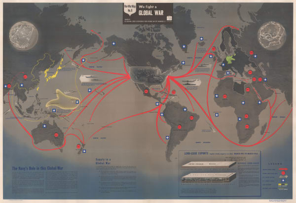
Nav War Map No. 6 - We Fight A Global War, 1944Sold£ 2,200.00
-
WW2-era map of the Pacific, 1944US Navy Educational Services SectionSeries: Washington, D.C.%3Cdiv%20class%3D%22title_and_year%22%3E%3Cspan%20class%3D%22title_and_year_title%22%3EWW2-era%20map%20of%20the%20Pacific%3C/span%3E%2C%20%3Cspan%20class%3D%22title_and_year_year%22%3E1944%3C/span%3E%3C/div%3E%3Cdiv%20class%3D%22artist%22%3EUS%20Navy%20Educational%20Services%20Section%3C/div%3E%3Cdiv%20class%3D%22series%22%3E%3Cspan%20class%3D%22artwork_caption_prefix%22%3ESeries%3A%3C/span%3E%20Washington%2C%20D.C.%3C/div%3EUS Navy Educational Services Section, WW2-era map of the Pacific, 1944Sold£ 3,000.00
Join our mailing list
* denotes required fields
We will process the personal data you have supplied to communicate with you in accordance with our Privacy Policy. You can unsubscribe or change your preferences at any time by clicking the link in our emails.
Contact
The Map House
54 Beauchamp Place,
London SW3 1NY,
United Kingdom
maps@themaphouse.com
+44 (0)20 7589 4325
Copyright © 2025 The Map House
This website uses cookies
This site uses cookies to help make it more useful to you. Please contact us to find out more about our Cookie Policy.