-
 Sebastian Münster, Tabvla Asiae XII, 1542 c.£ 1,250.00
 -
Tomaso Porcacchi, Descrittione Dell' Isola, 1604£ 275.00
-
Giovanni Antonio Magini, Tabula Asiae XII, 1617£ 425.00
-
Mercator Hondius, Ins. Ceilan: quae incolis Tenarisin dicitur, 1620 c.£ 2,350.00
-
Samuel Purchas, Ceilan Insula, 1625£ 325.00
-
Jan Jansson, Insula Zeilan, olim Taprobana, 1650 c.£ 1,750.00
-
Johannes van Keulen, Pascaert van't Eylandt Ceylon, 1683£ 4,450.00
-
Nicolas Sanson, Ceylan, et les Maldives, 1700£ 445.00
-
Josua & Reinier Ottens, Insula Ceilon et Madura Exactissime delineata, 1725 c.£ 2,250.00
-
Matthaus Seutter, Ceylon olim Taprobana, 1740 c.£ 2,450.00
-
Awnsham & John Churchill, Columbo [Colombo], 1740 c.£ 325.00
-
Awnsham & John Churchill, The Island of Manaer [Mannar], 1740 c.£ 325.00
-
Awnsham & John Churchill, [Negombo], 1740 c.£ 285.00
-
Jacques-Nicolas Bellin, Carte du Golphe de Bengale, 1747£ 245.00
-
Jacques-Nicolas Bellin, Carte de l'Isle de Ceylan, 1750£ 445.00
-
Robert de Vaugondy, Les Indes Orientales, 1751£ 425.00
-
Jacques-Nicolas Bellin, Carte de la Baye de Trinquemale, 1757£ 185.00
-
Tobias Conrad Lotter, Ceylon olim Taprobana, 1760 c.£ 1,650.00
-
Jacques-Nicolas Bellin, Plan de la Ville et Fort de Jaffa Nepatan, 1764£ 145.00
-
Robert Orme, A Map of the Coast of Coromandel from the River Gadevari , to Cape Coromin, 1775£ 495.00
-
Jean-Baptiste de Mannevillette, Plan of the Bay and Harbour of Trincomalay, on the Island of Ceylon, 1780 c.£ 975.00
-
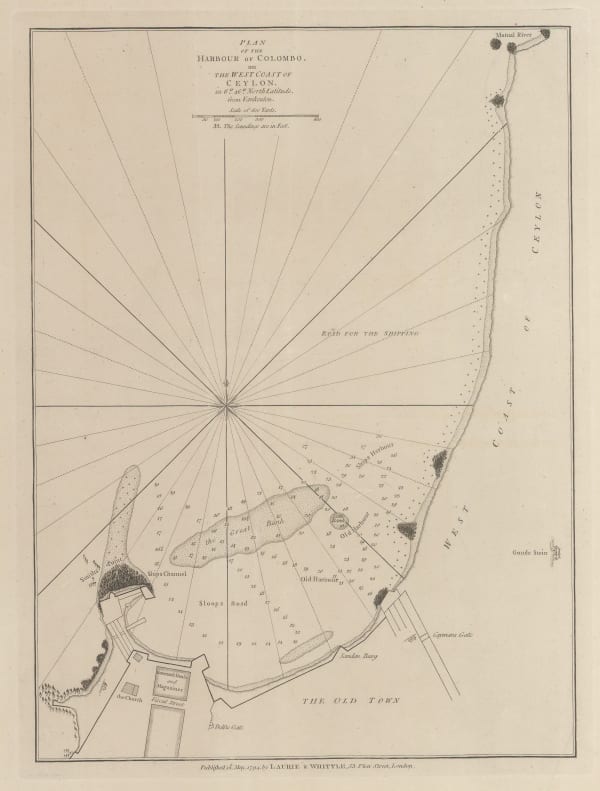
Laurie & Whittle, Plan of the Harbour of Colombo, on the West Coast of Ceylon, 1797£ 925.00
-
Aaron Arrowsmith, Carte de l'Ile de Ceilan, 1803 c.£ 775.00
-
Royal Geographical Society (RGS), The Paumbum Passage, Gulf of Manaar, 1834£ 125.00
-
British Admiralty, The Harbour and Bays of Trincomalee, 1835 c.£ 490.00
-
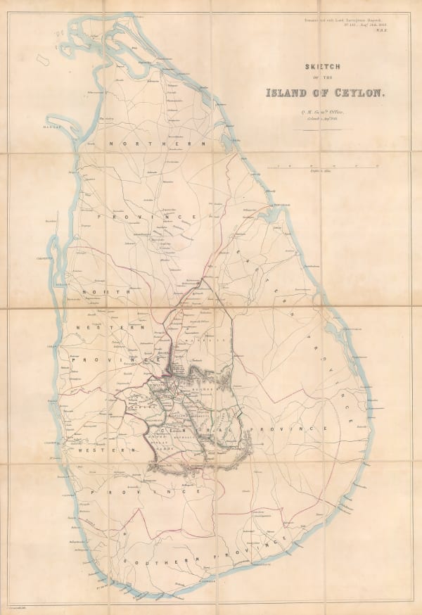
John Arrowsmith, Sketch of the Island of Ceylon, 1848£ 2,950.00
-
John Tallis, Ceylon, 1851£ 395.00
-
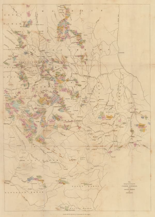
John Arrowsmith, Map Showing the Positions of the Coffee Estates in the Central Province of Ceylon, 1859£ 495.00
-
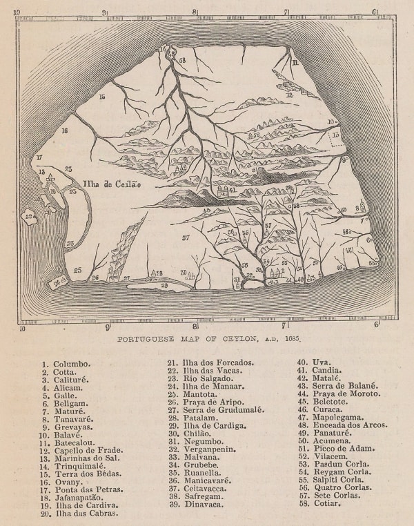
J. Emerson Tennent, Portuguese Map of Ceylon, A.D. 1685, 1859£ 42.00
-
Archibald Fullarton, British Possessions in the Indian Seas, 1860 c.£ 475.00
-
Letts & Son, Statistical & General Map of India, 1883£ 295.00
-
R.S. Templeton, Ceylon, 1910£ 850.00
-
Edward Stanford, Ceylon, 1911£ 275.00
-
E. Baudelot, Plan de Kandy, 1911£ 75.00
-
W.C.S. Ingles, Ceylon Motor Map, 1920£ 750.00
-
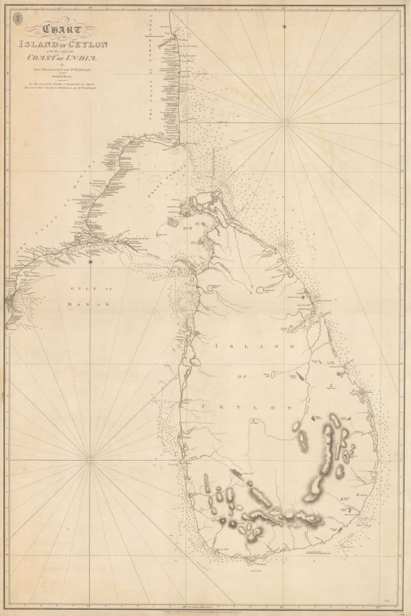
British Admiralty, Chart of the Island of Ceylon with the Adjacent Coast of India, 1922£ 3,450.00
-
Ceylon Survey Department, Ceylon, 1925£ 525.00
-
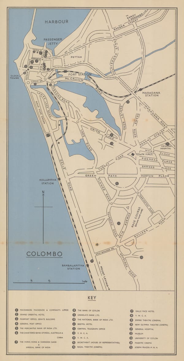
Edward Stanford, Colombo, 1925 c.£ 68.00
-
Ceylon Survey Department, Plan of Anuradhapura and Environs shewing Ancient Ruins, 1926£ 645.00
-
Edward Stanford, P&O Ports of Call - Colombo, 1930 (c.)£ 85.00
-
Macdonald Gill, Postcard - Map of Ceylon showing her Tea Industry, 1933 c.£ 275.00
-
Geographical Section, General Staff (GSGS), Survey Department Motor Map of Ceylon, 1945£ 325.00
-
Macdonald Gill, Ceylon her Tea & other Industries, 1950 c.£ 2,950.00
-
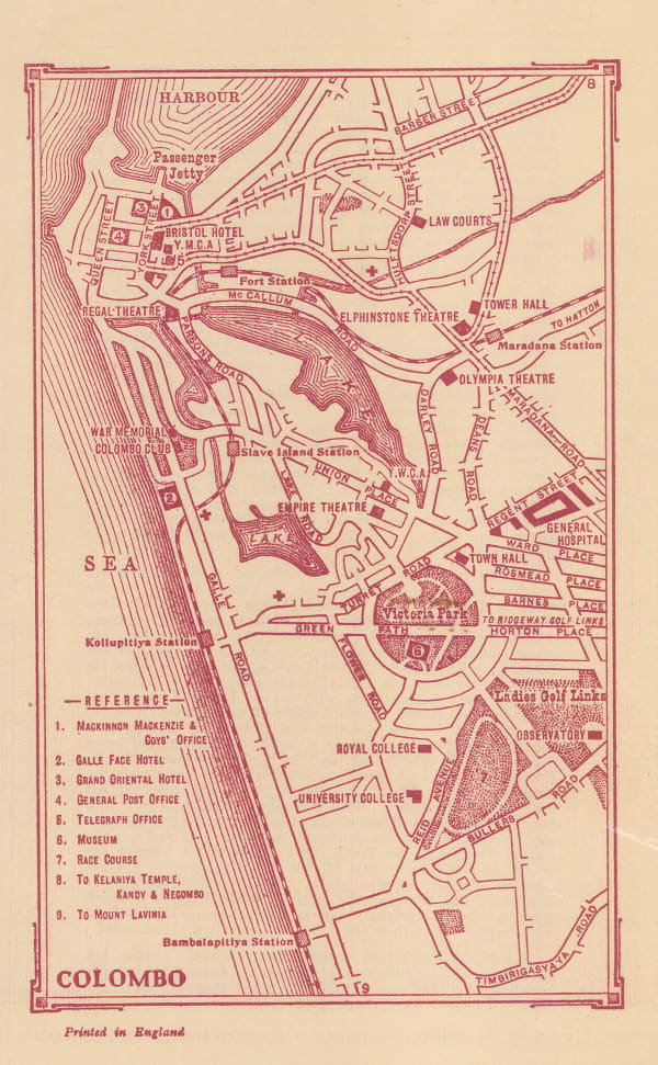
Ceylon Tourist Board, Tourist's Guide Map of Colombo, 1970 c.£ 220.00
Close
Search Inventory
Our entire inventory of over 10,000 antique and vintage maps is now available to browse by region, date, cartographer, and subject


![Awnsham & John Churchill, Columbo [Colombo], 1740 c.](https://artlogic-res.cloudinary.com/w_600,c_limit,f_auto,fl_lossy,q_auto/artlogicstorage/themaphouse/images/view/d4fa3f2d2cb2a577bf0071e30ad8cf52j/themaphouse-awnsham-john-churchill-columbo-colombo-1740-c..jpg)
![Awnsham & John Churchill, The Island of Manaer [Mannar], 1740 c.](https://artlogic-res.cloudinary.com/w_600,c_limit,f_auto,fl_lossy,q_auto/artlogicstorage/themaphouse/images/view/8295ea13d1e0fbdc9f9a6e7cb5c3d52cj/themaphouse-awnsham-john-churchill-the-island-of-manaer-mannar-1740-c..jpg)
![Awnsham & John Churchill, [Negombo], 1740 c.](https://artlogic-res.cloudinary.com/w_600,c_limit,f_auto,fl_lossy,q_auto/artlogicstorage/themaphouse/images/view/93b5e74237b0063d8747dbdf9b479bbfj/themaphouse-awnsham-john-churchill-negombo-1740-c..jpg)


Join our mailing list
* denotes required fields
We will process the personal data you have supplied to communicate with you in accordance with our Privacy Policy. You can unsubscribe or change your preferences at any time by clicking the link in our emails.
![]()