-
 Vincenzo Coronelli, Louisiana Parte Setteno Descritta, 1690 c.£ 1,150.00
 -
Antonio Zatta, Il Paese De Selvaggi Outauacesi E Kilistinesi Intorno Al Lago Superiore, 1780 c.£ 395.00
-
Rigobert Bonne, Kaart - Kanada, 1790 c.£ 425.00
-
Philippe Vandermaelen, Partie des Etats Unis, 1827£ 625.00
-
Society for the Diffusion of Useful Knowledge (SDUK), North America Sheet IV - Lake Superior, 1832£ 85.00
-
Capt. John B. Pope, Map of the Territory of Minnesota, 1849£ 2,750.00
-
Samuel Augustus Mitchell, County Map of Minnesota, 1862£ 245.00
-
Archibald Fullarton, United States - The North Central Section, 1870 c.£ 75.00
-
Justus Perthes, Die Hauptsaechlichsten Gebiete Der Indianer Mission in den Verein Staaten, 1871£ 125.00
-
Royal Geographical Society (RGS), Map to Illustrate Captain Willard Glazier's Voyage of Exploration to the Source of the Mississippi River drawn from delineations by his Indian Guide, Che-No-Wa-Ce-Sic, 1885£ 95.00
-
Justus Perthes, Petermann, Vereinigte Staaten von Amerika in 6 Blattern, Bl 2., 1885£ 85.00
-
Arbuckle Brothers Company, Minnesota, 1889£ 89.00
-
George Philip & Son Ltd., United States - Central Division, 1896£ 36.00
-
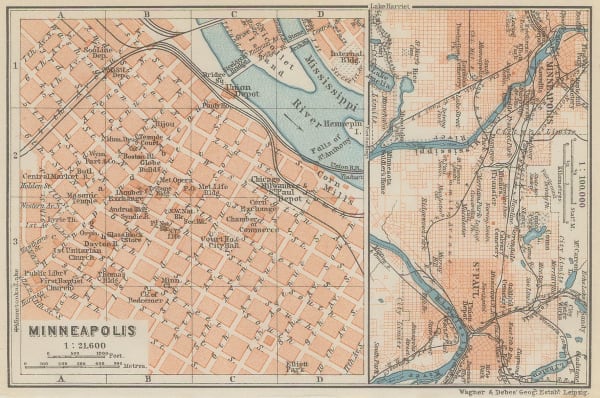
Karl Baedeker, Minneapolis, 1909£ 52.00
-
Karl Baedeker, St. Paul, 1909£ 38.00
-
Rand, McNally & Co., New Commercial Atlas Map of Minnesota, 1920 c.£ 345.00
-
Dore Ogrizek, Minnesota, 1946£ 65.00
Close
Search Inventory
Our entire inventory of over 10,000 antique and vintage maps is now available to browse by region, date, cartographer, and subject


Join our mailing list
* denotes required fields
We will process the personal data you have supplied to communicate with you in accordance with our Privacy Policy. You can unsubscribe or change your preferences at any time by clicking the link in our emails.
![]()