-
 Vincenzo Coronelli, Louisiana Parte Setteno Descritta, 1690 c.£ 1,150.00
 -
Jacques-Nicolas Bellin, Carte de l'Isle de Montreal et de ses Environs, 1744£ 575.00
-
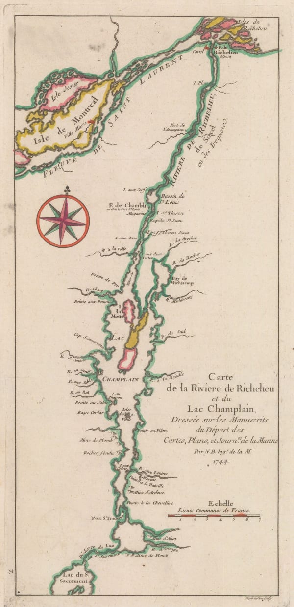
Jacques-Nicolas Bellin, Carte de la Riviere de Richelieu et du Lac Champlain, 1744£ 275.00
-
Homann Heirs, Partie Occidentale de la Nouvelle France ou du Canada, 1755£ 3,650.00
-
Jacques-Nicolas Bellin, Carte du Cours du Fleuve de St. Laurent, 1757£ 225.00
-
London Magazine, A Plan of the Fort and Bay of Frontenac, 1758£ 145.00
-
Gentleman's Magazine, A Map of the Island of Orleans with the Environs of Quebec, 1759£ 85.00
-
Andrea Scacciati, Carta rappresentante i cinque Laghi del Canada, 1763£ 675.00
-
Jacques-Nicolas Bellin, Idee de la Rade du Mingan, 1764£ 45.00
-
Jacques-Nicolas Bellin, Parti du Fleuve de Saint Laurent, 1764£ 295.00
-
Isaac Tirion, Quebek, de Hoofstad van Kanadaaan de Rivier van St. Laurens, 1765£ 845.00
-
Jonathan Carver, A New Map of the Province of Quebec, 1776£ 2,900.00
-
Antonio Zatta, La Pensilvania La Nuova York, Il Jersey Settentriole, Con La Parte Occidentale Del Connecticut, Massachusset-S-Bay E L'Irochesia, 1779£ 825.00
-
Antonio Zatta, Il Paese De Selvaggi Outauacesi E Kilistinesi Intorno Al Lago Superiore, 1780 c.£ 395.00
-
Rigobert Bonne, Kaart - Kanada, 1790 c.£ 425.00
-
Philippe Vandermaelen, Partie de la Nouvelle Bretagne, 1827£ 220.00
-
Lt. Col. Joseph Bouchette, City of Montreal, 1832£ 195.00
-
Society for the Diffusion of Useful Knowledge (SDUK), North America Sheet IV - Lake Superior, 1832£ 85.00
-
Lt. Col. Joseph Bouchette, Plan of the Town of Goderich, Upper Canada, 1832£ 125.00
-
Lt. Col. Joseph Bouchette, Plan of the Town of Guelf, Upper Canada, 1832£ 125.00
-
Lt. Col. Joseph Bouchette, Sketch of Bytown Ottawa River, 1832£ 325.00
-
Hansard, Carte de L'Isle de Montréal, 1837£ 525.00
-
James Wyld, A New Map of the Province of Lower Canada, 1840£ 775.00
-
Jeremiah Greenleaf, East Part of Canada, 1842£ 45.00
-
Samuel Augustus Mitchell, Canada West formerly Upper Canada, 1846£ 325.00
-
John Tallis, West Canada, 1851£ 375.00
-
Morse & Gaston, Canada East, 1857£ 32.00
-
Archibald Fullarton, Quebec, 1870 c.£ 45.00
-
Society for the Diffusion of Useful Knowledge (SDUK), North America Sheet III - The Dominion of Canada. Ontario with parts of New York, Pennsylvania, and Michigan, 1875£ 245.00
-
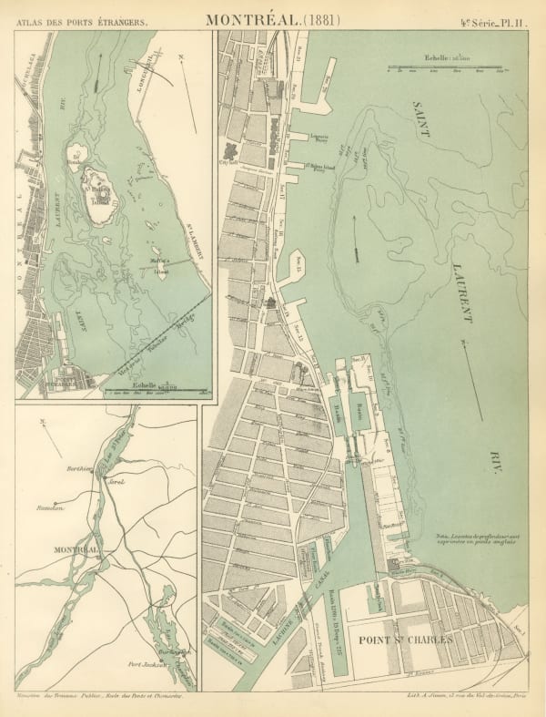
A. Simon, Montreal, 1881£ 325.00
-
Letts & Son, Statistical and General Map of Canada, 1883£ 48.00
-
A. Simon, Quebec, 1888£ 175.00
-
Letts & Son, Lake Superior, 1889£ 92.00
-
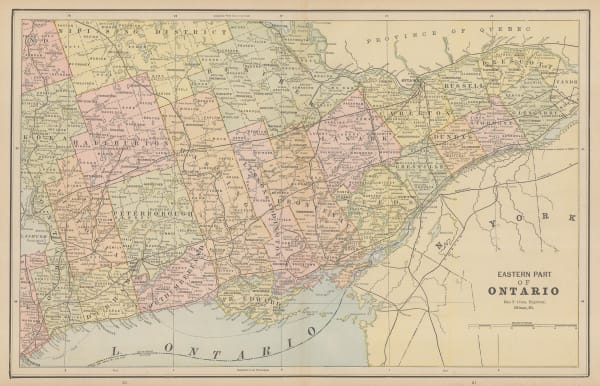
George Cram, Eastern Part of Ontario, 1889£ 52.00
-
George Cram, South-Western Part of Ontario, 1889£ 52.00
-
George Cram, Ontario, 1897£ 225.00
-
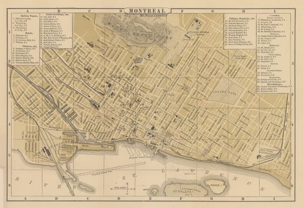
D. Appleton & Company, Montreal, 1898£ 95.00
-
C. J. Pilkey, Plan of the City of Toronto, 1903£ 625.00
-
Karl Baedeker, Quebec, 1905 c.£ 48.00
-
Karl Baedeker, Sault Ste. Marie, 1908£ 28.00
-
Walter Boldero Paton, Map of the Province of Ontario Canada, 1912£ 68.00
-
Arthur Oligny, City of Montreal, 1947£ 295.00
Close
Search Inventory
Our entire inventory of over 10,000 antique and vintage maps is now available to browse by region, date, cartographer, and subject


Join our mailing list
* denotes required fields
We will process the personal data you have supplied to communicate with you in accordance with our Privacy Policy. You can unsubscribe or change your preferences at any time by clicking the link in our emails.
![]()