- All
- AFRICA
- ▪ Central Africa
- ▪ East Africa
- ▪ North Africa
- ▪ Southern Africa
- ▪ West Africa
- ▪ Atlantic Islands
- AMERICAS
-
▪ United States (USA)
- USA - East
- USA - Midwest
- USA - Northeast
- USA - Southeast
- USA - West & Southwest
- Alabama
- Alaska
- Arizona
- Arkansas
- California
- Colorado
- Connecticut
- Delaware
- Florida
- Georgia
- Hawaii
- Idaho
- Illinois
- Indiana
- Iowa
- Kansas
- Kentucky
- Louisiana
- Maine
- Maryland
- Massachusetts
- Michigan
- Minnesota
- Mississippi
- Missouri
- Montana
- Nebraska
- Nevada
- New Hampshire
- New Jersey
- New Mexico
- New York
- New York City
- North Carolina
- North Dakota
- Ohio
- Oklahoma
- Oregon
- Pennsylvania
- Rhode Island
- South Carolina
- South Dakota
- Tennessee
- Texas
- Utah
- Vermont
- Virginia
- Washington
- Washington, D.C.
- West Virginia
- Wisconsin
- Wyoming
- ▪ North America
- ▪ South America
- ▪ Caribbean
- ASIA
- ▪ East Asia
- ▪ Southeast Asia
- ▪ India & South Asia
- ▪ Middle East & Turkey
- BRITISH ISLES
- ▪ London
-
▪ England
- English Cities
- Bedfordshire
- Berkshire
- Buckinghamshire
- Cambridgeshire
- Cheshire
- Cornwall
- Cumbria
- Derbyshire
- Devon
- Dorset
- Durham
- Essex
- Gloucestershire
- Hampshire
- Herefordshire
- Hertfordshire
- Huntingdonshire
- Isle of Wight
- Kent
- Lancashire
- Leicestershire
- Lincolnshire
- Middlesex
- Norfolk
- Northamptonshire
- Northumberland
- Nottinghamshire
- Oxfordshire
- Rutland
- Shropshire
- Somerset
- Staffordshire
- Suffolk
- Surrey
- Sussex
- Warwickshire
- Wiltshire
- Worcestershire
- Yorkshire
- Yorkshire East Riding
- Yorkshire North Riding
- Yorkshire West Riding
- ▪ Ireland
- ▪ Scotland
- ▪ Wales
- EUROPE
- ▪ Austria & Switzerland
- ▪ Benelux Region
- ▪ Central & Eastern Europe
- ▪ France & Monaco
- ▪ Germany
- ▪ Greece
- ▪ Italy
- ▪ Mediterranean Sea
- ▪ Spain & Portugal
- ▪ Scandinavia & Baltics
- ▪ Russia, Ukraine & Caucasus
- OCEANIA
- ▪ Australia
- ▪ New Zealand
- ▪ Pacific Ocean & Islands
- ▪ Papua New Guinea
- POLAR
- CELESTIAL
- WORLD
- GLOBES & INSTRUMENTS
- THEMATIC
- COLLABORATIONS
Hartmann Schedel
Ptolemaic World Map with Mythical Creatures, 1493
14 ½ x 20 in
37 x 51 cm
37 x 51 cm
WLD3888
%3Cdiv%20class%3D%22artist%22%3EHartmann%20Schedel%3C/div%3E%3Cdiv%20class%3D%22title_and_year%22%3E%3Cspan%20class%3D%22title_and_year_title%22%3EPtolemaic%20World%20Map%20with%20Mythical%20Creatures%3C/span%3E%2C%20%3Cspan%20class%3D%22title_and_year_year%22%3E1493%3C/span%3E%3C/div%3E%3Cdiv%20class%3D%22dimensions%22%3E14%20%C2%BD%20x%2020%20in%3Cbr/%3E%0A37%20x%2051%20cm%3C/div%3E
Das ander alter der werlt Hartmann Schedel's 'Nuremberg Chronicle' has been referred to as the first world wide travel book and one of the most important books ever printed....
Das ander alter der werlt
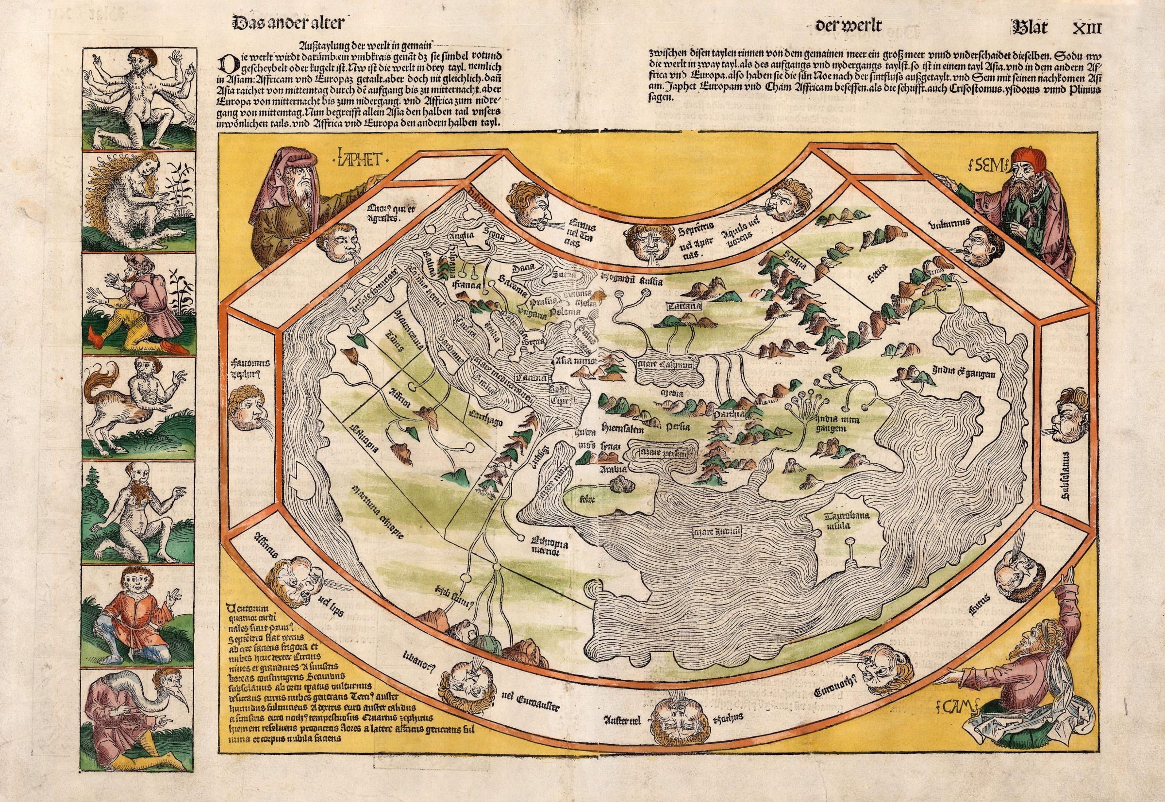
Hartmann Schedel's "Nuremberg Chronicle" has been referred to as the first world wide travel book and one of the most important books ever printed. It is a chronicle of the history of the world from its creation to modern times. Some of the events it narrates are a mixture of legend, myth and fable but it also refers to new inventions and contains multiple geographical descriptions and urban illustrations, many of which are the first recorded engraved image of that particular location. It also includes two maps, one of the world and one of the Holy Roman Empire, although this is called Greater Germany and includes Scandinavia and the British Isles.
There were multiple contributors to both the engravings and the text, including the wood cutters, Michael Woldemutt, his stepson Wilhelm Pleydenwurff and most notably, a young Albrecht Durer who was apprenticed to Woldemutt between 1486-89 and godson to Anton Koberger, the publisher of the Chronicle. Although as an apprentice it would have been uncredited, Durer is believed to have been involved in the engraving of many of the plates.
The work was highly successful and issued in both Latin and German in 1493 together with a much reduced version published in 1497. Current academic opinion credits Hieronymus Munzer as the author of the map of the world included in the Chronicle. Munzer was a doctor, traveller and polymath who contributed to many of the geographical sections within the volume. He was also a friend of Martin Behaim, the maker of world's oldest globe.
Geographically, the map is believed to be based on the small map added to a new edition of Pomponius Mela's "Cosmographia Geographia" published in Venice in 1482 by Erhard Ratdolt. Erhard was known to have settled in Augsburg after 1486, explaining the availability of his map. Generally it follows the orthodox belief of a landlocked Indian Ocean with a distorted but clear depiction of the lands of the Far East. It also bears a very early depiction of Scandinavia and the Orkney Islands. Stylistically, it continues to emulate Ratdolt in its clarity, with few features in the interior. This draws particular attention to the great rivers of the world such as the Nile in Egypt and the Volga and Ural, both discharging into the Caspian Sea. This clarity is a marked departure from its predecessors published in Ulm in 1482 and 1486. The major innovation on Schedel's map is the inclusion of Portuguese discoveries on the west coast of Africa, accounting for the much longer coastline of the continent in comparison to previous Ptolemaic maps. In addition this map also has a large unidentified island off the west of the continent, possibly referencing the discovery of the Cape Verde Islands.
Aesthetically, the map bears a collection of wind heads on its borders, a common feature on early Ptolemaic maps. It also illustrates the sons of Noah, Shem, Japhet and Ham. Finally, and most unusually, a border on the left, bears a continuation of a gallery of unusual and legendary beings initially illustrated on the previous page. The descriptions for these images are thought to have been sourced mostly from the classics, mainly the "De Mirabilibus Mundi" or "Wonders of the World" by Solinus who in turn used Pomponius Mela and Pliny's Natural History as sources for his work.
Schedel's map is considered to be one of the cornerstones of any collection of world maps and is the most accessible of the 15th century maps of the world.
[WLD3888]
Publications
Shirley, 19.
Share
- Tumblr
1
of
191
Join our mailing list
* denotes required fields
We will process the personal data you have supplied to communicate with you in accordance with our Privacy Policy. You can unsubscribe or change your preferences at any time by clicking the link in our emails.
Contact
The Map House
54 Beauchamp Place,
London SW3 1NY,
United Kingdom
maps@themaphouse.com
+44 (0)20 7589 4325
![]()
Copyright © 2025 The Map House
This website uses cookies
This site uses cookies to help make it more useful to you. Please contact us to find out more about our Cookie Policy.