- All
- AFRICA
- ▪ Central Africa
- ▪ East Africa
- ▪ North Africa
- ▪ Southern Africa
- ▪ West Africa
- ▪ Atlantic Islands
- AMERICAS
-
▪ United States (USA)
- USA - East
- USA - Midwest
- USA - Northeast
- USA - Southeast
- USA - West & Southwest
- Alabama
- Alaska
- Arizona
- Arkansas
- California
- Colorado
- Connecticut
- Delaware
- Florida
- Georgia
- Hawaii
- Idaho
- Illinois
- Indiana
- Iowa
- Kansas
- Kentucky
- Louisiana
- Maine
- Maryland
- Massachusetts
- Michigan
- Minnesota
- Mississippi
- Missouri
- Montana
- Nebraska
- Nevada
- New Hampshire
- New Jersey
- New Mexico
- New York
- New York City
- North Carolina
- North Dakota
- Ohio
- Oklahoma
- Oregon
- Pennsylvania
- Rhode Island
- South Carolina
- South Dakota
- Tennessee
- Texas
- Utah
- Vermont
- Virginia
- Washington
- Washington, D.C.
- West Virginia
- Wisconsin
- Wyoming
- ▪ North America
- ▪ South America
- ▪ Caribbean
- ASIA
- ▪ East Asia
- ▪ Southeast Asia
- ▪ India & South Asia
- ▪ Middle East & Turkey
- BRITISH ISLES
- ▪ London
-
▪ England
- English Cities
- Bedfordshire
- Berkshire
- Buckinghamshire
- Cambridgeshire
- Cheshire
- Cornwall
- Cumbria
- Derbyshire
- Devon
- Dorset
- Durham
- Essex
- Gloucestershire
- Hampshire
- Herefordshire
- Hertfordshire
- Huntingdonshire
- Isle of Wight
- Kent
- Lancashire
- Leicestershire
- Lincolnshire
- Middlesex
- Norfolk
- Northamptonshire
- Northumberland
- Nottinghamshire
- Oxfordshire
- Rutland
- Shropshire
- Somerset
- Staffordshire
- Suffolk
- Surrey
- Sussex
- Warwickshire
- Wiltshire
- Worcestershire
- Yorkshire
- Yorkshire East Riding
- Yorkshire North Riding
- Yorkshire West Riding
- ▪ Ireland
- ▪ Scotland
- ▪ Wales
- EUROPE
- ▪ Austria & Switzerland
- ▪ Benelux Region
- ▪ Central & Eastern Europe
- ▪ France & Monaco
- ▪ Germany
- ▪ Greece
- ▪ Italy
- ▪ Mediterranean Sea
- ▪ Spain & Portugal
- ▪ Scandinavia & Baltics
- ▪ Russia, Ukraine & Caucasus
- OCEANIA
- ▪ Australia
- ▪ New Zealand
- ▪ Pacific Ocean & Islands
- ▪ Papua New Guinea
- POLAR
- CELESTIAL
- WORLD
- GLOBES & INSTRUMENTS
- THEMATIC
- COLLABORATIONS
John Stockdale
Store ship Alexander's voyage from Port Jackson to Batavia, 1789
11 1/2 x 14 1/2 in
29 x 37 cm
29 x 37 cm
AUNZ2834
£ 195.00
John Stockdale, Store ship Alexander's voyage from Port Jackson to Batavia, 1789
Sold
%3Cdiv%20class%3D%22artist%22%3EJohn%20Stockdale%3C/div%3E%3Cdiv%20class%3D%22title_and_year%22%3E%3Cspan%20class%3D%22title_and_year_title%22%3EStore%20ship%20Alexander%27s%20voyage%20from%20Port%20Jackson%20to%20Batavia%3C/span%3E%2C%20%3Cspan%20class%3D%22title_and_year_year%22%3E1789%3C/span%3E%3C/div%3E%3Cdiv%20class%3D%22dimensions%22%3E11%201/2%20x%2014%201/2%20in%3Cbr/%3E%0A29%20x%2037%20cm%3C/div%3E
A Chart of the Track of the Alexander on Her Homeward Passage from Port Jackson on East Coast of New South Wales to Batavia This map published by John...
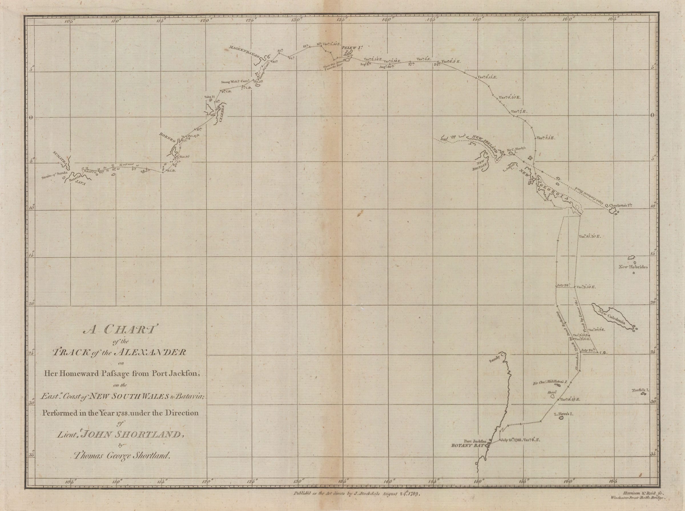
A Chart of the Track of the Alexander on Her Homeward Passage from Port Jackson on East Coast of New South Wales to Batavia
This map published by John Stockdale tracks the progress of the Alexander, a store ship in the First Fleet to Australia, on her homeward voyage back to the United Kingdom. This leg of the journey is between Port Jackson and Batavia on Java.
The map was drawn by George Shortland, a seventeen year old midshipman, under the supervision of John Shortland, his father. John had a varied career in the Navy, but specialized in logistics and transport, which led to him being appointed Naval Agent, supervising logistics for the First Fleet. He did a superb job and on his return journey, mapped several unknown islands in the Pacific on his way to Batavia on Java. He also carried the first dispatches from Governor Phillip to the Secretary of State for Foreign Affairs, Francis Osborne. Although he was nominally only a Lieutenant, his word carried much influence, as he recommended that the eastern coast of Australia be carefully surveyed and this led to the appointment of Matthew Flinders to this task. He had two sons, another John, and the afore mentioned George, both of whom also had distinguished careers in the Navy.
It was maps and documents of men such as Shortland that fashioned and led to the development of Australia. [AUNZ2834]
Share
- Tumblr
Join our mailing list
* denotes required fields
We will process the personal data you have supplied to communicate with you in accordance with our Privacy Policy. You can unsubscribe or change your preferences at any time by clicking the link in our emails.
Contact
The Map House
54 Beauchamp Place,
London SW3 1NY,
United Kingdom
maps@themaphouse.com
+44 (0)20 7589 4325
![]()
Copyright © 2025 The Map House
This website uses cookies
This site uses cookies to help make it more useful to you. Please contact us to find out more about our Cookie Policy.