- All
- AFRICA
- ▪ Central Africa
- ▪ East Africa
- ▪ North Africa
- ▪ Southern Africa
- ▪ West Africa
- ▪ Atlantic Islands
- AMERICAS
-
▪ United States (USA)
- USA - East
- USA - Midwest
- USA - Northeast
- USA - Southeast
- USA - West & Southwest
- Alabama
- Alaska
- Arizona
- Arkansas
- California
- Colorado
- Connecticut
- Delaware
- Florida
- Georgia
- Hawaii
- Idaho
- Illinois
- Indiana
- Iowa
- Kansas
- Kentucky
- Louisiana
- Maine
- Maryland
- Massachusetts
- Michigan
- Minnesota
- Mississippi
- Missouri
- Montana
- Nebraska
- Nevada
- New Hampshire
- New Jersey
- New Mexico
- New York
- New York City
- North Carolina
- North Dakota
- Ohio
- Oklahoma
- Oregon
- Pennsylvania
- Rhode Island
- South Carolina
- South Dakota
- Tennessee
- Texas
- Utah
- Vermont
- Virginia
- Washington
- Washington, D.C.
- West Virginia
- Wisconsin
- Wyoming
- ▪ North America
- ▪ South America
- ▪ Caribbean
- ASIA
- ▪ East Asia
- ▪ Southeast Asia
- ▪ India & South Asia
- ▪ Middle East & Turkey
- BRITISH ISLES
- ▪ London
-
▪ England
- English Cities
- Bedfordshire
- Berkshire
- Buckinghamshire
- Cambridgeshire
- Cheshire
- Cornwall
- Cumbria
- Derbyshire
- Devon
- Dorset
- Durham
- Essex
- Gloucestershire
- Hampshire
- Herefordshire
- Hertfordshire
- Huntingdonshire
- Isle of Wight
- Kent
- Lancashire
- Leicestershire
- Lincolnshire
- Middlesex
- Norfolk
- Northamptonshire
- Northumberland
- Nottinghamshire
- Oxfordshire
- Rutland
- Shropshire
- Somerset
- Staffordshire
- Suffolk
- Surrey
- Sussex
- Warwickshire
- Wiltshire
- Worcestershire
- Yorkshire
- Yorkshire East Riding
- Yorkshire North Riding
- Yorkshire West Riding
- ▪ Ireland
- ▪ Scotland
- ▪ Wales
- EUROPE
- ▪ Austria & Switzerland
- ▪ Benelux Region
- ▪ Central & Eastern Europe
- ▪ France & Monaco
- ▪ Germany
- ▪ Greece
- ▪ Italy
- ▪ Mediterranean Sea
- ▪ Spain & Portugal
- ▪ Scandinavia & Baltics
- ▪ Russia, Ukraine & Caucasus
- OCEANIA
- ▪ Australia
- ▪ New Zealand
- ▪ Pacific Ocean & Islands
- ▪ Papua New Guinea
- POLAR
- CELESTIAL
- WORLD
- GLOBES & INSTRUMENTS
- THEMATIC
- COLLABORATIONS
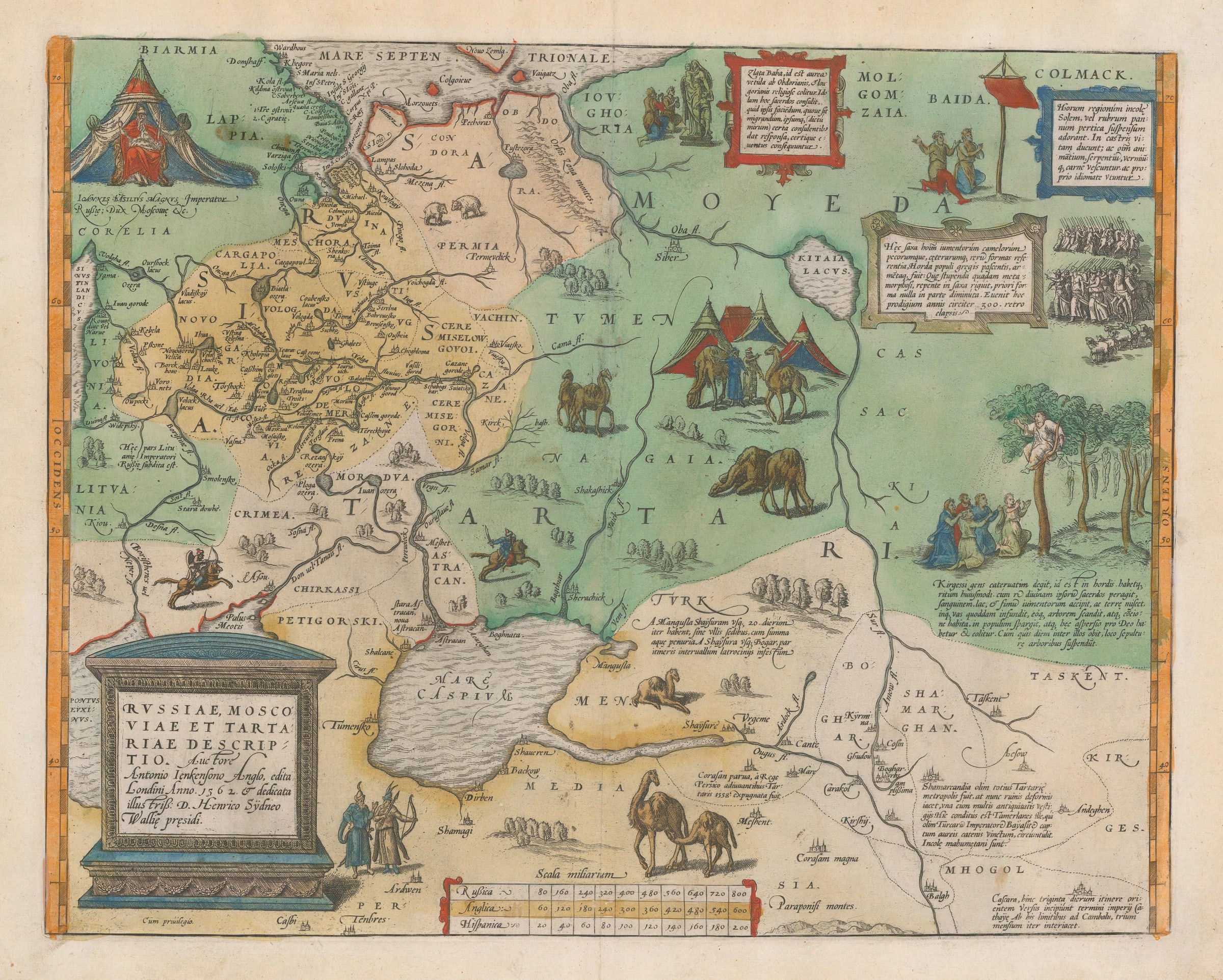
Abraham Ortelius
37 x 46 cm
An early copper engraved map of Russia showing the region from the Baltic Sea, Lithuania and the Black Sea to the Sur River, Tashkent, the Cossack regions and Colmack. The map is based on the information gathered by the Englishman Anthony Jenkinson of the Muscovy Company, during four expeditions from 1558 to 1571. These expeditions reflected his attempts to create a new Silk Road to China, going through Russia, northern Europe and ultimately Great Britain. In the process he met Ivan the Terrible and gained limited access to his cartographic archives.
One of the most famous features of this map is the wealth of illustrations present throughout its face. These include the figure of a Russian potentate on the upper left and multiple images of camels, the most important beast of burden in the region. Several other vignettes feature sun worshippers on the upper right and an image of worshippers on the upper centre venerating the “Zlata Baba” or Golden Hag. This practice is also mentioned on Sigismund Herberstein’s map of 1549.
One of the most intriguing images is on the extreme right of the map, featuring seemingly hanging corpses; this has often been misinterpreted but it is actually an image of funeral rites. The panel accompanying the image translates as follows:
‘Kirgessen people live in troops or hoardes. They have the following custom: when a priest performs a religious ceremony, he obtains blood, milk, and dung of beasts of burden, and mixes it with earth. He pours this in a specific vessel and climbs a tree with it, and when there is a gathering, he sprinkles in over the people, and this sprinkling is considered to be divine, and is worshipped. When one of them dies, that person is hung up in a tree by way of burial.’
The map was published by one of the founding fathers of cartography, Abraham Ortelius, in his greatest work, "Theatrum Orbis Terrarum". It was the first modern atlas in that it was the first uniformly sized, systematic collection of maps of the world's countries; its information was up-to-date and the layout masterly. The first edition contained 70 maps, but in the 42 editions between 1570 and 1612, this number increased to over 160. Information was drawn from every possible source - Ortelius selected only the best maps of his contemporaries for inclusion.
Latin text on reverse. Image available on request. Original colour. [RUS2671]
- X
- Tumblr
Join our mailing list
* denotes required fields
We will process the personal data you have supplied to communicate with you in accordance with our Privacy Policy. You can unsubscribe or change your preferences at any time by clicking the link in our emails.
Contact
The Map House
54 Beauchamp Place,
London SW3 1NY,
United Kingdom
maps@themaphouse.com
+44 (0)20 7589 4325
![]()
This website uses cookies
This site uses cookies to help make it more useful to you. Please contact us to find out more about our Cookie Policy.
Join our mailing list
* denotes required fields
We will process the personal data you have supplied to communicate with you in accordance with our Privacy Policy. You can unsubscribe or change your preferences at any time by clicking the link in our emails.