- All
- AFRICA
- ▪ Central Africa
- ▪ East Africa
- ▪ North Africa
- ▪ Southern Africa
- ▪ West Africa
- ▪ Atlantic Islands
- AMERICAS
-
▪ United States (USA)
- USA - East
- USA - Midwest
- USA - Northeast
- USA - Southeast
- USA - West & Southwest
- Alabama
- Alaska
- Arizona
- Arkansas
- California
- Colorado
- Connecticut
- Delaware
- Florida
- Georgia
- Hawaii
- Idaho
- Illinois
- Indiana
- Iowa
- Kansas
- Kentucky
- Louisiana
- Maine
- Maryland
- Massachusetts
- Michigan
- Minnesota
- Mississippi
- Missouri
- Montana
- Nebraska
- Nevada
- New Hampshire
- New Jersey
- New Mexico
- New York
- New York City
- North Carolina
- North Dakota
- Ohio
- Oklahoma
- Oregon
- Pennsylvania
- Rhode Island
- South Carolina
- South Dakota
- Tennessee
- Texas
- Utah
- Vermont
- Virginia
- Washington
- Washington, D.C.
- West Virginia
- Wisconsin
- Wyoming
- ▪ North America
- ▪ South America
- ▪ Caribbean
- ASIA
- ▪ East Asia
- ▪ Southeast Asia
- ▪ India & South Asia
- ▪ Middle East & Turkey
- BRITISH ISLES
- ▪ London
-
▪ England
- English Cities
- Bedfordshire
- Berkshire
- Buckinghamshire
- Cambridgeshire
- Cheshire
- Cornwall
- Cumbria
- Derbyshire
- Devon
- Dorset
- Durham
- Essex
- Gloucestershire
- Hampshire
- Herefordshire
- Hertfordshire
- Huntingdonshire
- Isle of Wight
- Kent
- Lancashire
- Leicestershire
- Lincolnshire
- Middlesex
- Norfolk
- Northamptonshire
- Northumberland
- Nottinghamshire
- Oxfordshire
- Rutland
- Shropshire
- Somerset
- Staffordshire
- Suffolk
- Surrey
- Sussex
- Warwickshire
- Wiltshire
- Worcestershire
- Yorkshire
- Yorkshire East Riding
- Yorkshire North Riding
- Yorkshire West Riding
- ▪ Ireland
- ▪ Scotland
- ▪ Wales
- EUROPE
- ▪ Austria & Switzerland
- ▪ Benelux Region
- ▪ Central & Eastern Europe
- ▪ France & Monaco
- ▪ Germany
- ▪ Greece
- ▪ Italy
- ▪ Mediterranean Sea
- ▪ Spain & Portugal
- ▪ Scandinavia & Baltics
- ▪ Russia, Ukraine & Caucasus
- OCEANIA
- ▪ Australia
- ▪ New Zealand
- ▪ Pacific Ocean & Islands
- ▪ Papua New Guinea
- POLAR
- CELESTIAL
- WORLD
- GLOBES & INSTRUMENTS
- THEMATIC
- COLLABORATIONS
Jonas Hanway
The Caspian Sea, Aral Sea and Central Asia, 1753
18 x 19 ½ in
46 x 50 cm
46 x 50 cm
RUS2608
£ 825.00
Jonas Hanway, The Caspian Sea, Aral Sea and Central Asia, 1753
Sold
%3Cdiv%20class%3D%22artist%22%3EJonas%20Hanway%3C/div%3E%3Cdiv%20class%3D%22title_and_year%22%3E%3Cspan%20class%3D%22title_and_year_title%22%3EThe%20Caspian%20Sea%2C%20Aral%20Sea%20and%20Central%20Asia%3C/span%3E%2C%20%3Cspan%20class%3D%22title_and_year_year%22%3E1753%3C/span%3E%3C/div%3E%3Cdiv%20class%3D%22dimensions%22%3E18%20x%2019%20%C2%BD%20in%3Cbr/%3E%0A46%20x%2050%20cm%3C/div%3E
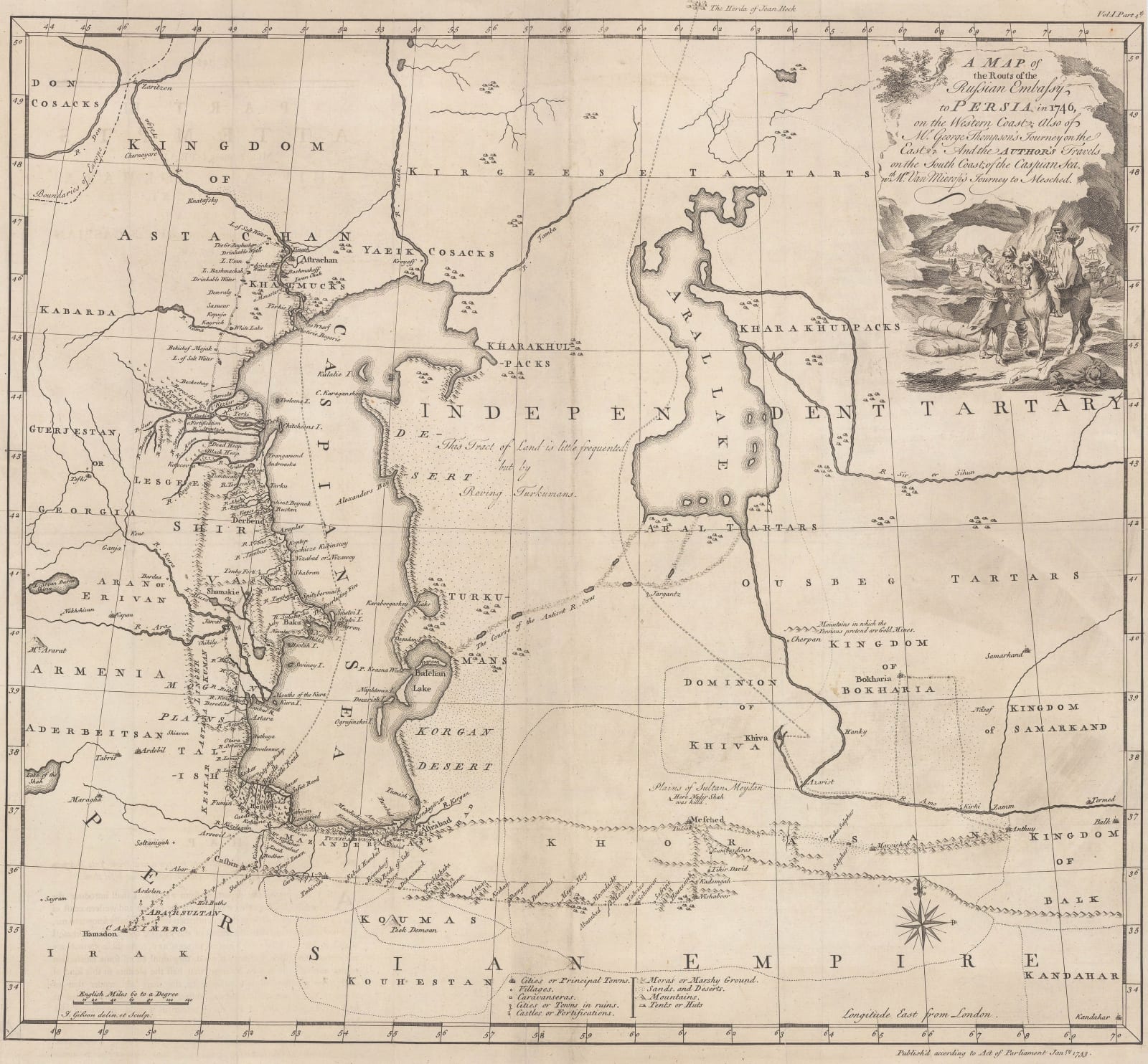
A Map of the Routs of the Russian Embassy to Persia in 1746 This map of the Caspian Sea and its surroundings was compiled by the English merchant-explorer Jonas...
A Map of the Routs of the Russian Embassy to Persia in 1746
This map of the Caspian Sea and its surroundings was compiled by the English merchant-explorer Jonas Hanway from his own travels and the accounts of a Russian Embassy to Persia in 1746. Hanway's routes, the routes of the Russian Embassy, and the routes of two other explorers - George Thompson and Martin Kyck van Mierop - are all marked on the map.
This is one of the earliest European maps of this region to be based on first-hand accounts, making it an important record. Though much of the map remains empty and uncharted, the routes themselves and the adjacent regions are well mapped with many villages, caravanserais, encampments, and fortifications marked. Groups of tents are scattered around much of the map to suggest the present of nomadic tribes whose permanent locations are unknown.
In modern-day terms, this map covers the Caspian Sea coasts of Georgia, Russia, Azerbaijan, Iran, Turkmenistan, and Kazakhstan, extending as far inland as Samarkand in Uzbekistan.
[RUS2608]
Share
- Tumblr
Join our mailing list
* denotes required fields
We will process the personal data you have supplied to communicate with you in accordance with our Privacy Policy. You can unsubscribe or change your preferences at any time by clicking the link in our emails.
Contact
The Map House
54 Beauchamp Place,
London SW3 1NY,
United Kingdom
maps@themaphouse.com
+44 (0)20 7589 4325

Copyright © 2025 The Map House
This website uses cookies
This site uses cookies to help make it more useful to you. Please contact us to find out more about our Cookie Policy.

