- All
- AFRICA
- ▪ Central Africa
- ▪ East Africa
- ▪ North Africa
- ▪ Southern Africa
- ▪ West Africa
- ▪ Atlantic Islands
- AMERICAS
-
▪ United States (USA)
- USA - East
- USA - Midwest
- USA - Northeast
- USA - Southeast
- USA - West & Southwest
- Alabama
- Alaska
- Arizona
- Arkansas
- California
- Colorado
- Connecticut
- Delaware
- Florida
- Georgia
- Hawaii
- Idaho
- Illinois
- Indiana
- Iowa
- Kansas
- Kentucky
- Louisiana
- Maine
- Maryland
- Massachusetts
- Michigan
- Minnesota
- Mississippi
- Missouri
- Montana
- Nebraska
- Nevada
- New Hampshire
- New Jersey
- New Mexico
- New York
- New York City
- North Carolina
- North Dakota
- Ohio
- Oklahoma
- Oregon
- Pennsylvania
- Rhode Island
- South Carolina
- South Dakota
- Tennessee
- Texas
- Utah
- Vermont
- Virginia
- Washington
- Washington, D.C.
- West Virginia
- Wisconsin
- Wyoming
- ▪ North America
- ▪ South America
- ▪ Caribbean
- ASIA
- ▪ East Asia
- ▪ Southeast Asia
- ▪ India & South Asia
- ▪ Middle East & Turkey
- BRITISH ISLES
- ▪ London
-
▪ England
- English Cities
- Bedfordshire
- Berkshire
- Buckinghamshire
- Cambridgeshire
- Cheshire
- Cornwall
- Cumbria
- Derbyshire
- Devon
- Dorset
- Durham
- Essex
- Gloucestershire
- Hampshire
- Herefordshire
- Hertfordshire
- Huntingdonshire
- Isle of Wight
- Kent
- Lancashire
- Leicestershire
- Lincolnshire
- Middlesex
- Norfolk
- Northamptonshire
- Northumberland
- Nottinghamshire
- Oxfordshire
- Rutland
- Shropshire
- Somerset
- Staffordshire
- Suffolk
- Surrey
- Sussex
- Warwickshire
- Wiltshire
- Worcestershire
- Yorkshire
- Yorkshire East Riding
- Yorkshire North Riding
- Yorkshire West Riding
- ▪ Ireland
- ▪ Scotland
- ▪ Wales
- EUROPE
- ▪ Austria & Switzerland
- ▪ Benelux Region
- ▪ Central & Eastern Europe
- ▪ France & Monaco
- ▪ Germany
- ▪ Greece
- ▪ Italy
- ▪ Mediterranean Sea
- ▪ Spain & Portugal
- ▪ Scandinavia & Baltics
- ▪ Russia, Ukraine & Caucasus
- OCEANIA
- ▪ Australia
- ▪ New Zealand
- ▪ Pacific Ocean & Islands
- ▪ Papua New Guinea
- POLAR
- CELESTIAL
- WORLD
- GLOBES & INSTRUMENTS
- THEMATIC
- COLLABORATIONS
John Speed
40 x 51 cm
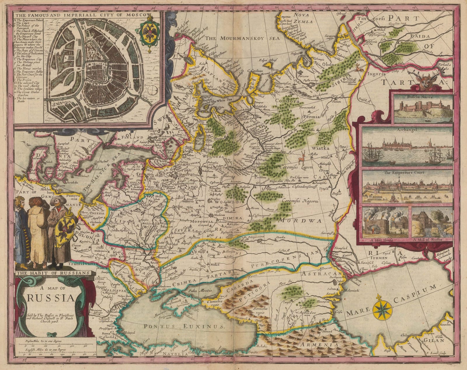
The first English atlas map of Russia added posthumously to Speed's atlas in 1676. Broadly covering the region known as European Russia, it is derived from contemporary Dutch maps.
Although John Speed's name is used as a marketing tool for this edition of the "Theatre of the Empire of Great Britaine and A Prospect of the Most Famous Parts of the World", Speed had died almost fifty years previously. Yet such was his fame and reputation that his atlas was still considered commercially viable for publishers. In addition, this posthumous 1676 edition was augmented with five new maps, including this map of Russia. Thus, although uncredited, and engraved by Francis Lamb as marked on the lower right, this is still perceived as the first and only edition of Speed's map of Russia due to its inclusion in the atlas.
Geographically, it is based on a map first issued by Hessel Gerritz in 1612-13. Gerritz in turn was given a manuscript by Isaac Massa, a Dutch wheat merchant with extensive contacts in Eastern Europe. He had obtained a manuscript copy of the original map from the archives of King Sigismund of Poland, who supposedly sourced it from the court of Boris Godunov. One of the most interesting features of the map is the theory that the city plan of Moscow on the upper left was based on a survey supervised by Feodor Godunov, son of Boris and supposedly a prodigy with a great interest in geography.
Gerritz published the map in a commercial prospectus for trading opportunities in Eastern Europe but it was quickly appropriated and used by the Blaeu family in their Atlas Novus from the 1630s onwards and from then on by the major Dutch publishing houses during the Golden Age of the 17th century.
It was the standard template for Russian maps throughout this period and the engravers employed by Bassett and Chiswell follow the geographical model carefully, including the city plan of Moscow on the upper left and several vignettes on the centre right, including Narva Castle and the Kremlin.
Of particular note is the contemporary English description of Russia in the 17th century printed on the reverse of the map.
English text on verso. Image available on request. Coloured.
[RUS2509]
- X
- Tumblr
Join our mailing list
* denotes required fields
We will process the personal data you have supplied to communicate with you in accordance with our Privacy Policy. You can unsubscribe or change your preferences at any time by clicking the link in our emails.
Contact
The Map House
54 Beauchamp Place,
London SW3 1NY,
United Kingdom
maps@themaphouse.com
+44 (0)20 7589 4325

This website uses cookies
This site uses cookies to help make it more useful to you. Please contact us to find out more about our Cookie Policy.
Join our mailing list
* denotes required fields
We will process the personal data you have supplied to communicate with you in accordance with our Privacy Policy. You can unsubscribe or change your preferences at any time by clicking the link in our emails.

