- All
- AFRICA
- ▪ Central Africa
- ▪ East Africa
- ▪ North Africa
- ▪ Southern Africa
- ▪ West Africa
- ▪ Atlantic Islands
- AMERICAS
-
▪ United States (USA)
- USA - East
- USA - Midwest
- USA - Northeast
- USA - Southeast
- USA - West & Southwest
- Alabama
- Alaska
- Arizona
- Arkansas
- California
- Colorado
- Connecticut
- Delaware
- Florida
- Georgia
- Hawaii
- Idaho
- Illinois
- Indiana
- Iowa
- Kansas
- Kentucky
- Louisiana
- Maine
- Maryland
- Massachusetts
- Michigan
- Minnesota
- Mississippi
- Missouri
- Montana
- Nebraska
- Nevada
- New Hampshire
- New Jersey
- New Mexico
- New York
- New York City
- North Carolina
- North Dakota
- Ohio
- Oklahoma
- Oregon
- Pennsylvania
- Rhode Island
- South Carolina
- South Dakota
- Tennessee
- Texas
- Utah
- Vermont
- Virginia
- Washington
- Washington, D.C.
- West Virginia
- Wisconsin
- Wyoming
- ▪ North America
- ▪ South America
- ▪ Caribbean
- ASIA
- ▪ East Asia
- ▪ Southeast Asia
- ▪ India & South Asia
- ▪ Middle East & Turkey
- BRITISH ISLES
- ▪ London
-
▪ England
- English Cities
- Bedfordshire
- Berkshire
- Buckinghamshire
- Cambridgeshire
- Cheshire
- Cornwall
- Cumbria
- Derbyshire
- Devon
- Dorset
- Durham
- Essex
- Gloucestershire
- Hampshire
- Herefordshire
- Hertfordshire
- Huntingdonshire
- Isle of Wight
- Kent
- Lancashire
- Leicestershire
- Lincolnshire
- Middlesex
- Norfolk
- Northamptonshire
- Northumberland
- Nottinghamshire
- Oxfordshire
- Rutland
- Shropshire
- Somerset
- Staffordshire
- Suffolk
- Surrey
- Sussex
- Warwickshire
- Wiltshire
- Worcestershire
- Yorkshire
- Yorkshire East Riding
- Yorkshire North Riding
- Yorkshire West Riding
- ▪ Ireland
- ▪ Scotland
- ▪ Wales
- EUROPE
- ▪ Austria & Switzerland
- ▪ Benelux Region
- ▪ Central & Eastern Europe
- ▪ France & Monaco
- ▪ Germany
- ▪ Greece
- ▪ Italy
- ▪ Mediterranean Sea
- ▪ Spain & Portugal
- ▪ Scandinavia & Baltics
- ▪ Russia, Ukraine & Caucasus
- OCEANIA
- ▪ Australia
- ▪ New Zealand
- ▪ Pacific Ocean & Islands
- ▪ Papua New Guinea
- POLAR
- CELESTIAL
- WORLD
- GLOBES & INSTRUMENTS
- THEMATIC
- COLLABORATIONS
Willem & Jan Blaeu
41 x 52 cm
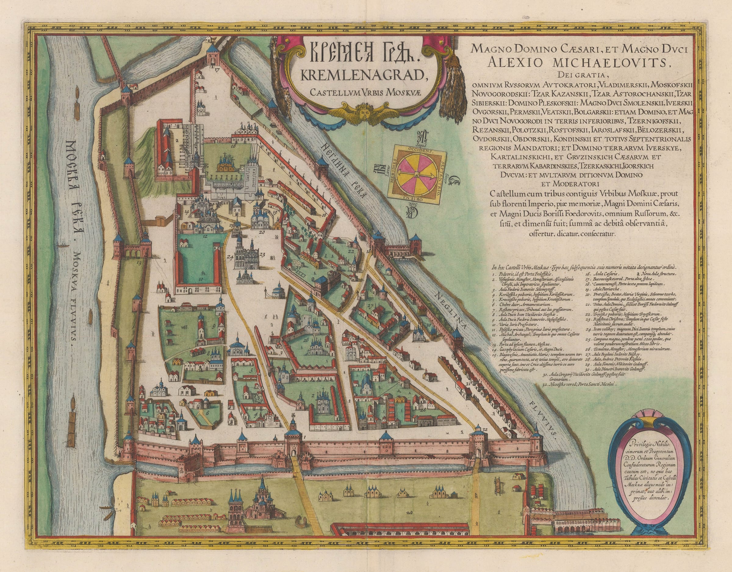
This map has often been associated with its partner, the plan of the whole of Moscow. The latter first appeared as an inset on Gerritz's map of Russia in 1612-13. However, the dedication on the upper right of this piece is to Archduke and Emperor of Russia, Aleksey Mikhailovich, who did not ascend to the throne until 1645. This suggests that Blaeu specifically prepared this plate much later than the first appearance of the Moscow city plan.
The geography of the Kremlin has been lifted directly from the larger scale plan of the city. On the upper right, as well as the dedication to the current Tsar, there is also a note on the panel acknowledging the memory of Archduke Boris Feodorovitch also known as Tsar Boris Godunov, who is thought to have commissioned the original survey in the late sixteenth century. Finally, there is a key to important buildings which have been numbered on the map.
This example is from the 1664 Dutch edition of the Atlas Major, with corresponding text on the reverse (image available on request.
[RUS2286]
The Blaeu Family
For much of the 17th Century the firm of Blaeu were the dominant mapmakers at a time when Dutch cartography was universally acknowledged to lead the world. Established in 1596 by Willem Janszoon Blaeu (1571-1638), who had studied as a young man under the great astronomer, Tycho Brahe, it originally produced globes and scientific instruments. However, the firm soon expanded into map making and publishing, and eventually became one of the most important and prolific map producers in Amsterdam.
In 1623 they published the "Het Licht der Zeevaerdt" an atlas of sea-charts. In 1629 Willem and his son Jan (1596-1673) purchased 37 engraved plates from the widow of their rival Hondius and the following year they produced their first land atlas, the "Atlantis Appendix" which contained sixty maps. In 1635 this was expanded into the "Atlas Novus" a major world atlas in six volumes. This contained a county atlas of England and Wales and from 1635-59 was published in editions in Dutch, Latin, French, German and Spanish.
After the death of his father, Jan (also spelt Joan or Johannes) Blaeu embarked on one of the most ambitious publishing undertakings of the 17th Century, the printing of the "Atlas Maior". This magnificent work was to contain nearly six hundred maps and, depending on edition, varied between nine and twelve volumes. The exquisite engraving allied with typically lovely hand-colouring make maps from the "Novus" and "Maior" atlases some of the finest ever produced.
The "Atlas Maior" was to be the crowning glory of the Blaeu firm. In 1672 a disastrous fire swept through the Blaeu printing house destroying much of the stock and most of the copper engraving plates. The following year Jan died and the surviving plates were dispersed.
The period between 1570 and 1670 is known as the Golden Age of Dutch Cartography and it is a measure of the Blaeu's achievements that they were the dominant cartographers throughout most of this period. Reflecting their contemporary reputations Willem and Jan were in turn both appointed Hydrographer to the Dutch East India Company (the VOC) and their atlases were frequently presented to foreign sovereigns and potentates by the Dutch government.
- X
- Tumblr
Join our mailing list
* denotes required fields
We will process the personal data you have supplied to communicate with you in accordance with our Privacy Policy. You can unsubscribe or change your preferences at any time by clicking the link in our emails.
Contact
The Map House
54 Beauchamp Place,
London SW3 1NY,
United Kingdom
maps@themaphouse.com
+44 (0)20 7589 4325
![]()
This website uses cookies
This site uses cookies to help make it more useful to you. Please contact us to find out more about our Cookie Policy.
Join our mailing list
* denotes required fields
We will process the personal data you have supplied to communicate with you in accordance with our Privacy Policy. You can unsubscribe or change your preferences at any time by clicking the link in our emails.