Jan Blaeu
Early city plan of Moscow, 1664
16 ½ x 21 in
42 x 53 cm
42 x 53 cm
RUS2285
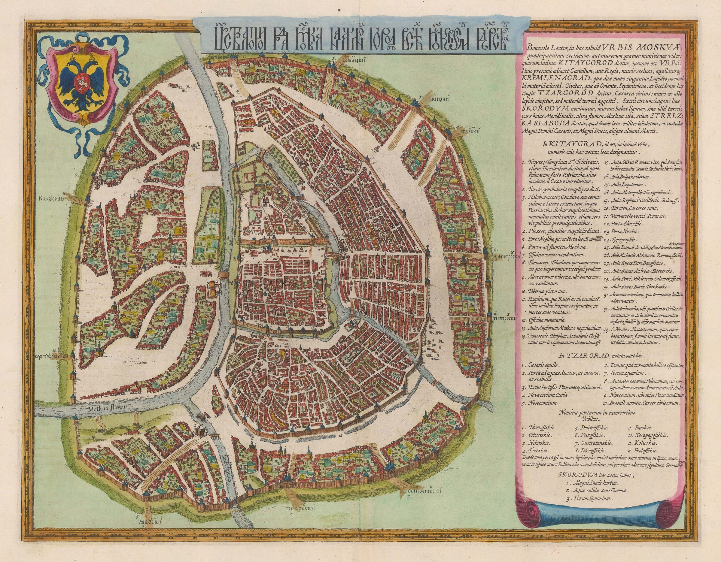
Urbis Moskuae Blaeu claims that this city plan is taken from an original map belonging to Feodor Godunov, son of Boris, a young man known for his intelligence and...
Urbis Moskuae
Blaeu claims that this city plan is taken from an original map belonging to Feodor Godunov, son of Boris, a young man known for his intelligence and particular interest in geography.
Feodor briefly succeeded his father but was killed, aged 16, by a rival for the throne. His survey of the city is not known in its original form but a version of it was sent to Sigismund III King of Poland,Sweden and Grand-Duke of Lithuania.
Isaac Massa, a Dutch merchant-adventurer and diplomat, was active in this region during the early 17th century, and obtained cartographic material of these lands. Massa in turn supplied information to Hessel Gerritz who published "The Land of the Samoyeds" which is illustrated with a map of Russia with an inset of this plan of Moscow. This map was a template for several maps of Russia throughout the mid 17th century; indeed, the Blaeu family used the same plate, merely erasing Gerritz's name and substituting their own when publishing the map in their "Atlas Novus" in 1635.
The plan shows the explosive growth of the city in the late 16th century, which was divided into four quarters: the newly built outer ring, the Zembiyanoy gorod or Earthen city which was not finished until 1591. The others are the Kremlin, the Kitai gorod or commercial heart of the city and the Belgorod or White City. A large panel of Latin text explains their position and history as well as providing a key for the important buildings which have been numbered. The gates on the earthen outer wall of the city have also been named and numbered.
In its current form, this map appeared in Joan Blaeu's "Atlas Major", The work also includes a second related map, focussing on the Kremlin. These are the only two city plans in this work of over five hundred maps and it is not known why Blaeu chose to include them over all other cities.
This example is from the 1664 Dutch edition (image of verso available on request).
[RUS2285]
The Blaeu Family
For much of the 17th Century the firm of Blaeu were the dominant mapmakers at a time when Dutch cartography was universally acknowledged to lead the world. Established in 1596 by Willem Janszoon Blaeu (1571-1638), who had studied as a young man under the great astronomer, Tycho Brahe, it originally produced globes and scientific instruments. However, the firm soon expanded into map making and publishing, and eventually became one of the most important and prolific map producers in Amsterdam.
In 1623 they published the "Het Licht der Zeevaerdt" an atlas of sea-charts. In 1629 Willem and his son Jan (1596-1673) purchased 37 engraved plates from the widow of their rival Hondius and the following year they produced their first land atlas, the "Atlantis Appendix" which contained sixty maps. In 1635 this was expanded into the "Atlas Novus" a major world atlas in six volumes. This contained a county atlas of England and Wales and from 1635-59 was published in editions in Dutch, Latin, French, German and Spanish.
After the death of his father, Jan (also spelt Joan or Johannes) Blaeu embarked on one of the most ambitious publishing undertakings of the 17th Century, the printing of the "Atlas Maior". This magnificent work was to contain nearly six hundred maps and, depending on edition, varied between nine and twelve volumes. The exquisite engraving allied with typically lovely hand-colouring make maps from the "Novus" and "Maior" atlases some of the finest ever produced.
The "Atlas Maior" was to be the crowning glory of the Blaeu firm. In 1672 a disastrous fire swept through the Blaeu printing house destroying much of the stock and most of the copper engraving plates. The following year Jan died and the surviving plates were dispersed.
The period between 1570 and 1670 is known as the Golden Age of Dutch Cartography and it is a measure of the Blaeu's achievements that they were the dominant cartographers throughout most of this period. Reflecting their contemporary reputations Willem and Jan were in turn both appointed Hydrographer to the Dutch East India Company (the VOC) and their atlases were frequently presented to foreign sovereigns and potentates by the Dutch government.
Join our mailing list
* denotes required fields
We will process the personal data you have supplied to communicate with you in accordance with our Privacy Policy. You can unsubscribe or change your preferences at any time by clicking the link in our emails.
![]()
Join our mailing list
* denotes required fields
We will process the personal data you have supplied to communicate with you in accordance with our Privacy Policy. You can unsubscribe or change your preferences at any time by clicking the link in our emails.