- All
- AFRICA
- ▪ Central Africa
- ▪ East Africa
- ▪ North Africa
- ▪ Southern Africa
- ▪ West Africa
- ▪ Atlantic Islands
- AMERICAS
-
▪ United States (USA)
- USA - East
- USA - Midwest
- USA - Northeast
- USA - Southeast
- USA - West & Southwest
- Alabama
- Alaska
- Arizona
- Arkansas
- California
- Colorado
- Connecticut
- Delaware
- Florida
- Georgia
- Hawaii
- Idaho
- Illinois
- Indiana
- Iowa
- Kansas
- Kentucky
- Louisiana
- Maine
- Maryland
- Massachusetts
- Michigan
- Minnesota
- Mississippi
- Missouri
- Montana
- Nebraska
- Nevada
- New Hampshire
- New Jersey
- New Mexico
- New York
- New York City
- North Carolina
- North Dakota
- Ohio
- Oklahoma
- Oregon
- Pennsylvania
- Rhode Island
- South Carolina
- South Dakota
- Tennessee
- Texas
- Utah
- Vermont
- Virginia
- Washington
- Washington, D.C.
- West Virginia
- Wisconsin
- Wyoming
- ▪ North America
- ▪ South America
- ▪ Caribbean
- ASIA
- ▪ East Asia
- ▪ Southeast Asia
- ▪ India & South Asia
- ▪ Middle East & Turkey
- BRITISH ISLES
- ▪ London
-
▪ England
- English Cities
- Bedfordshire
- Berkshire
- Buckinghamshire
- Cambridgeshire
- Cheshire
- Cornwall
- Cumbria
- Derbyshire
- Devon
- Dorset
- Durham
- Essex
- Gloucestershire
- Hampshire
- Herefordshire
- Hertfordshire
- Huntingdonshire
- Isle of Wight
- Kent
- Lancashire
- Leicestershire
- Lincolnshire
- Middlesex
- Norfolk
- Northamptonshire
- Northumberland
- Nottinghamshire
- Oxfordshire
- Rutland
- Shropshire
- Somerset
- Staffordshire
- Suffolk
- Surrey
- Sussex
- Warwickshire
- Wiltshire
- Worcestershire
- Yorkshire
- Yorkshire East Riding
- Yorkshire North Riding
- Yorkshire West Riding
- ▪ Ireland
- ▪ Scotland
- ▪ Wales
- EUROPE
- ▪ Austria & Switzerland
- ▪ Benelux Region
- ▪ Central & Eastern Europe
- ▪ France & Monaco
- ▪ Germany
- ▪ Greece
- ▪ Italy
- ▪ Mediterranean Sea
- ▪ Spain & Portugal
- ▪ Scandinavia & Baltics
- ▪ Russia, Ukraine & Caucasus
- OCEANIA
- ▪ Australia
- ▪ New Zealand
- ▪ Pacific Ocean & Islands
- ▪ Papua New Guinea
- POLAR
- CELESTIAL
- WORLD
- GLOBES & INSTRUMENTS
- THEMATIC
- COLLABORATIONS
Jacob & Hendrik Keur
Double Hemisphere World Map, 1702
14 x 18 in
36 x 46 cm
36 x 46 cm
WLD4735
£ 3,950.00
Jacob & Hendrik Keur, Double Hemisphere World Map, 1702
Sold
%3Cdiv%20class%3D%22artist%22%3EJacob%20%26%20Hendrik%20Keur%3C/div%3E%3Cdiv%20class%3D%22title_and_year%22%3E%3Cspan%20class%3D%22title_and_year_title%22%3EDouble%20Hemisphere%20World%20Map%3C/span%3E%2C%20%3Cspan%20class%3D%22title_and_year_year%22%3E1702%3C/span%3E%3C/div%3E%3Cdiv%20class%3D%22dimensions%22%3E14%20x%2018%20in%3Cbr/%3E%0A36%20x%2046%20cm%3C/div%3E
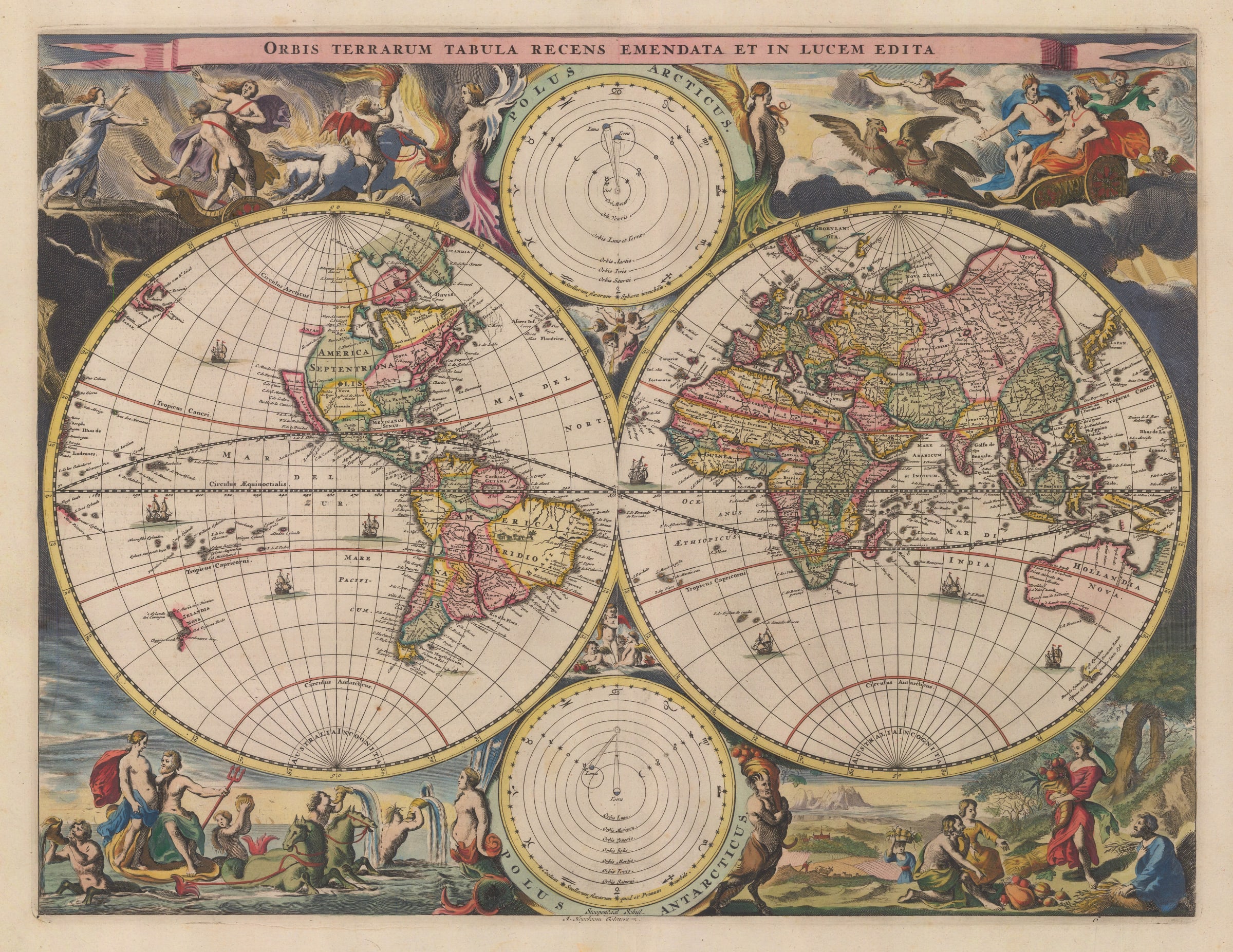
Orbis Terrarum Tabula Recens Emendata et in Lucem Edita Early 18th century double hemisphere map of the world first issued in 1682 presented in the style of the Dutch...
Orbis Terrarum Tabula Recens Emendata et in Lucem Edita
Early 18th century double hemisphere map of the world first issued in 1682 presented in the style of the Dutch Golden Age of Cartography.
This fine double hemisphere map is attributed to Hendrik and Jacob Keur. The Keur family had a long association with the publishing of Bibles. In the mid 17th century, Nicholas Visscher introduced the concept of binding a series of maps within Bibles to help illustrate the geographical panorama of the Biblical world. This series of maps varied from the editions of the Bible but usually included a plan of Jerusalem, a series of maps of the Holy Land focusing on specific Biblical epochs, a map showing Paradise and one “modern” double hemisphere map. This concept proved extremely popular and Visscher soon gained several imitators, including the Keur family.
Both geographically and artistically, this map is closely based on another of Nicholas Visscher’s maps. It was first published in 1658 and was bound in Visscher’s “Atlas Minor” as well as several other composite works. Visscher in turn based his map on the monumental wall of the world published by Joan Blaeu in 1648. Among several geographical innovations present on this world map for the first time is the integration of Tasman’s discoveries in Australia and New Zealand and the concept of Korea as a peninsula as opposed to an island as previously believed.
The Keur brothers reduced the map in size and introduced astronomical diagrams on the upper and lower centre as opposed to polar maps present on the Visscher map. These differences apart, the maps are generally the same. California is shown with its “flat topped” northern shore based on the map by Briggs and the large illustrated borders are scenes from famous myths such as the abduction of Persephone while simultaneously serving as allegories for the elements.
The engraver was Stoopendaal who often worked for and with Visscher.
Coloured. Dutch text on reverse. Image available upon request. [Shirley 513]
Share
- Tumblr
Join our mailing list
* denotes required fields
We will process the personal data you have supplied to communicate with you in accordance with our Privacy Policy. You can unsubscribe or change your preferences at any time by clicking the link in our emails.
Contact
The Map House
54 Beauchamp Place,
London SW3 1NY,
United Kingdom
maps@themaphouse.com
+44 (0)20 7589 4325
![]()
Copyright © 2025 The Map House
This website uses cookies
This site uses cookies to help make it more useful to you. Please contact us to find out more about our Cookie Policy.