- All
- AFRICA
- ▪ Central Africa
- ▪ East Africa
- ▪ North Africa
- ▪ Southern Africa
- ▪ West Africa
- ▪ Atlantic Islands
- AMERICAS
-
▪ United States (USA)
- USA - East
- USA - Midwest
- USA - Northeast
- USA - Southeast
- USA - West & Southwest
- Alabama
- Alaska
- Arizona
- Arkansas
- California
- Colorado
- Connecticut
- Delaware
- Florida
- Georgia
- Hawaii
- Idaho
- Illinois
- Indiana
- Iowa
- Kansas
- Kentucky
- Louisiana
- Maine
- Maryland
- Massachusetts
- Michigan
- Minnesota
- Mississippi
- Missouri
- Montana
- Nebraska
- Nevada
- New Hampshire
- New Jersey
- New Mexico
- New York
- New York City
- North Carolina
- North Dakota
- Ohio
- Oklahoma
- Oregon
- Pennsylvania
- Rhode Island
- South Carolina
- South Dakota
- Tennessee
- Texas
- Utah
- Vermont
- Virginia
- Washington
- Washington, D.C.
- West Virginia
- Wisconsin
- Wyoming
- ▪ North America
- ▪ South America
- ▪ Caribbean
- ASIA
- ▪ East Asia
- ▪ Southeast Asia
- ▪ India & South Asia
- ▪ Middle East & Turkey
- BRITISH ISLES
- ▪ London
-
▪ England
- English Cities
- Bedfordshire
- Berkshire
- Buckinghamshire
- Cambridgeshire
- Cheshire
- Cornwall
- Cumbria
- Derbyshire
- Devon
- Dorset
- Durham
- Essex
- Gloucestershire
- Hampshire
- Herefordshire
- Hertfordshire
- Huntingdonshire
- Isle of Wight
- Kent
- Lancashire
- Leicestershire
- Lincolnshire
- Middlesex
- Norfolk
- Northamptonshire
- Northumberland
- Nottinghamshire
- Oxfordshire
- Rutland
- Shropshire
- Somerset
- Staffordshire
- Suffolk
- Surrey
- Sussex
- Warwickshire
- Wiltshire
- Worcestershire
- Yorkshire
- Yorkshire East Riding
- Yorkshire North Riding
- Yorkshire West Riding
- ▪ Ireland
- ▪ Scotland
- ▪ Wales
- EUROPE
- ▪ Austria & Switzerland
- ▪ Benelux Region
- ▪ Central & Eastern Europe
- ▪ France & Monaco
- ▪ Germany
- ▪ Greece
- ▪ Italy
- ▪ Mediterranean Sea
- ▪ Spain & Portugal
- ▪ Scandinavia & Baltics
- ▪ Russia, Ukraine & Caucasus
- OCEANIA
- ▪ Australia
- ▪ New Zealand
- ▪ Pacific Ocean & Islands
- ▪ Papua New Guinea
- POLAR
- CELESTIAL
- WORLD
- GLOBES & INSTRUMENTS
- THEMATIC
- COLLABORATIONS
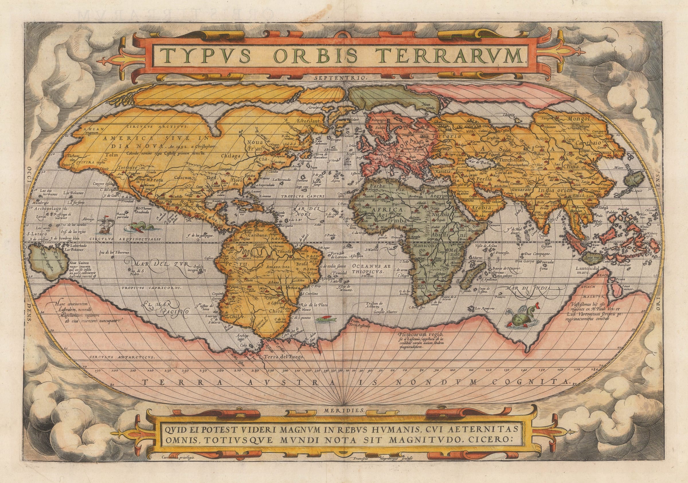
Abraham Ortelius
34 x 50 cm
His greatest work, the "Theatrum Orbis Terrarum", appeared in 1570 marking the beginning of an epoch in the history of cartography. It was the first modern atlas, a uniformly sized and systematically curated collection of maps of the world's countries; its information was current and although the contents were mainly European, it also contained maps of the separate continents and this world map. The first edition contained 53 maps, but in the 42 editions between 1570 and 1612, this number increased to over 160. Information was drawn from every possible source - Ortelius selected only the best maps of his contemporaries for inclusion.
Ortelius died on 23rd June 1598, a very wealthy and respected man, and was buried at St. Michael's in Antwerp.
Geographically, this map of the world is derived mostly from Gerhard Mercator's wall map issued in 1569. Notable features include the depiction of the north Pole as four separate islands, the inclusion of very obvious Northeast and Northwest Passages as well as the distinctive 'bulging' South America. To the south is the vast "Terra Australis Nondum Cognita" or Unknown Great Southern Land, which was an assimilation of sightings and legends of landmasses made during Magellan's circumnavigation, reports gleaned from the writings of Marco Polo and more nebulous sources such as early Spanish and Portuguese reports of lands to the south which would have gone through multiple sources. Interestingly, Ortelius himself credits the geographical information of Asia and the Far East to "M.Pauli: Ven" or Marco Polo of Venice and "Lud. Vartomanni", the far more obscure but highly intriguing Ludovico di Varthema. This credit can be seen on the lower right of the map which on the peninsula labelled "Beach".
The example of the map offered is the 1579 edition, with its distinctive cloud border. This version of the map, with its early geography and this border was issued in the first sixteen editions of the "Theatrum" until 1586.
Latin text on verso (image available on request).
Coloured. Shirley 122 [WLD4311]
- X
- Tumblr
Join our mailing list
* denotes required fields
We will process the personal data you have supplied to communicate with you in accordance with our Privacy Policy. You can unsubscribe or change your preferences at any time by clicking the link in our emails.
Contact
The Map House
54 Beauchamp Place,
London SW3 1NY,
United Kingdom
maps@themaphouse.com
+44 (0)20 7589 4325
![]()
This website uses cookies
This site uses cookies to help make it more useful to you. Please contact us to find out more about our Cookie Policy.
Join our mailing list
* denotes required fields
We will process the personal data you have supplied to communicate with you in accordance with our Privacy Policy. You can unsubscribe or change your preferences at any time by clicking the link in our emails.