- All
- AFRICA
- ▪ Central Africa
- ▪ East Africa
- ▪ North Africa
- ▪ Southern Africa
- ▪ West Africa
- ▪ Atlantic Islands
- AMERICAS
-
▪ United States (USA)
- USA - East
- USA - Midwest
- USA - Northeast
- USA - Southeast
- USA - West & Southwest
- Alabama
- Alaska
- Arizona
- Arkansas
- California
- Colorado
- Connecticut
- Delaware
- Florida
- Georgia
- Hawaii
- Idaho
- Illinois
- Indiana
- Iowa
- Kansas
- Kentucky
- Louisiana
- Maine
- Maryland
- Massachusetts
- Michigan
- Minnesota
- Mississippi
- Missouri
- Montana
- Nebraska
- Nevada
- New Hampshire
- New Jersey
- New Mexico
- New York
- New York City
- North Carolina
- North Dakota
- Ohio
- Oklahoma
- Oregon
- Pennsylvania
- Rhode Island
- South Carolina
- South Dakota
- Tennessee
- Texas
- Utah
- Vermont
- Virginia
- Washington
- Washington, D.C.
- West Virginia
- Wisconsin
- Wyoming
- ▪ North America
- ▪ South America
- ▪ Caribbean
- ASIA
- ▪ East Asia
- ▪ Southeast Asia
- ▪ India & South Asia
- ▪ Middle East & Turkey
- BRITISH ISLES
- ▪ London
-
▪ England
- English Cities
- Bedfordshire
- Berkshire
- Buckinghamshire
- Cambridgeshire
- Cheshire
- Cornwall
- Cumbria
- Derbyshire
- Devon
- Dorset
- Durham
- Essex
- Gloucestershire
- Hampshire
- Herefordshire
- Hertfordshire
- Huntingdonshire
- Isle of Wight
- Kent
- Lancashire
- Leicestershire
- Lincolnshire
- Middlesex
- Norfolk
- Northamptonshire
- Northumberland
- Nottinghamshire
- Oxfordshire
- Rutland
- Shropshire
- Somerset
- Staffordshire
- Suffolk
- Surrey
- Sussex
- Warwickshire
- Wiltshire
- Worcestershire
- Yorkshire
- Yorkshire East Riding
- Yorkshire North Riding
- Yorkshire West Riding
- ▪ Ireland
- ▪ Scotland
- ▪ Wales
- EUROPE
- ▪ Austria & Switzerland
- ▪ Benelux Region
- ▪ Central & Eastern Europe
- ▪ France & Monaco
- ▪ Germany
- ▪ Greece
- ▪ Italy
- ▪ Mediterranean Sea
- ▪ Spain & Portugal
- ▪ Scandinavia & Baltics
- ▪ Russia, Ukraine & Caucasus
- OCEANIA
- ▪ Australia
- ▪ New Zealand
- ▪ Pacific Ocean & Islands
- ▪ Papua New Guinea
- POLAR
- CELESTIAL
- WORLD
- GLOBES & INSTRUMENTS
- THEMATIC
- COLLABORATIONS
Heinrich Scherer
World Map, 1700 c.
9 x 14 in
23 x 35 cm
23 x 35 cm
WLD3680
£ 2,650.00
Heinrich Scherer, World Map, 1700 c.
Sold
%3Cdiv%20class%3D%22artist%22%3EHeinrich%20Scherer%3C/div%3E%3Cdiv%20class%3D%22title_and_year%22%3E%3Cspan%20class%3D%22title_and_year_title%22%3EWorld%20Map%3C/span%3E%2C%20%3Cspan%20class%3D%22title_and_year_year%22%3E1700%20c.%3C/span%3E%3C/div%3E%3Cdiv%20class%3D%22dimensions%22%3E9%20x%2014%20in%3Cbr/%3E%0A23%20x%2035%20cm%3C/div%3E
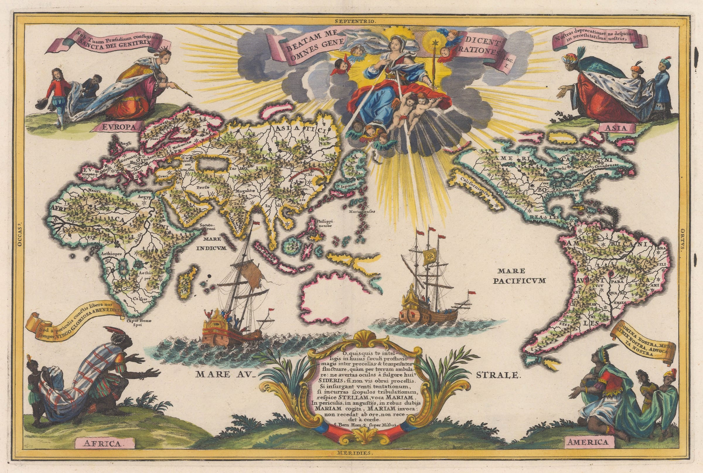
Heinrich Scherer was a Jesuit priest and Professor of Mathematics in Munich, as well as being the official tutor to the Princes of Bavaria and Mantua. Between 1702-10, he produced...
Heinrich Scherer was a Jesuit priest and Professor of Mathematics in Munich, as well as being the official tutor to the Princes of Bavaria and Mantua. Between 1702-10, he produced his Atlas Novus in seven parts. The maps within celebrate the spread of the Christian Faith throughout the world and focus on the physical and natural world. They are beautifully engraved and lavishly illustrated, often with religious figures and events, very much in the baroque style which was so prevalent at the time.
The Atlas is particularly famous for the amount of world maps within its contents, many of which are shown from a Polar perspective.
This is a typically decorative world map. It is centered on the Pacific and the continents are drawn without any geo-political details, focusing purely on physical geography. The engraving is both highly skilled and stylised with the continents showing their shores artificially jagged to indicate the presence of multiple coves, harbours and inlets. Scherer was able to draw on contemporary Jesuit reports for the geography of the Great Lakes in the United States, the west coast of Mexico and South America showing them with surprising accuracy for the time. His erroneous conjecture that California is an island was contemporaneously orthodox, although his depiction of a definite Northwest Passage was a feature that many other map makers were wary of by this stage. In Africa, Scherer follows the classical theory first propagated by Ptolemy that the Nile is sourced from a large lake in the southern part of the continent. He also sources two other major African rivers, the Congo and the Niger from the same lake and illustrates another theory that the Niger and the Nile were connected; this converts Africa into three separate islands. Again, this was a river configuration that was often shown on maps of the later 16th and early 17th century. On Asia, the most prominent features are the size of the Caspian Sea and the Great Wall of China.
There are several names on the map which correspond to individual countries but as mentioned above, there are no political borders. There are also many stars marked throughout the map, which correspond to known Catholic missions.
Even by the standards of Scherer, the decorations on this map are elaborate. The major vignette is situated on the upper centre and features the Virgin Mary bestowing her graces in the form of rays throughout the world. The title is a quote from the Gospel of Luke Chapter I. Each corner bears an allegorical figure of a continent shown in a position of worship of Mary. Two large ships sail on the Indian and Pacific Oceans, the latter bearing a flag with the initials "MR", short for "Maria Regina" or Mary the Queen. This is a symbol of appreciation for the many missionaries sailing to far lands in the name of the Church. The lower panel is an exhortation in poetic form to look to Mary during life's storms and tribulations. There is a reference saying that she can be called upon in the locations marked with a star, with her being the greatest star of all.
Scherer's maps, with their emphasis on theme and physical geography, are some of the more curious and beautiful pieces available to collectors, with few contemporary map makers being able to match him aesthetically.
[Shirley 630] [WLD3680]
Share
- Tumblr
Join our mailing list
* denotes required fields
We will process the personal data you have supplied to communicate with you in accordance with our Privacy Policy. You can unsubscribe or change your preferences at any time by clicking the link in our emails.
Contact
The Map House
54 Beauchamp Place,
London SW3 1NY,
United Kingdom
maps@themaphouse.com
+44 (0)20 7589 4325
![]()
Copyright © 2025 The Map House
This website uses cookies
This site uses cookies to help make it more useful to you. Please contact us to find out more about our Cookie Policy.