- All
- AFRICA
- ▪ Central Africa
- ▪ East Africa
- ▪ North Africa
- ▪ Southern Africa
- ▪ West Africa
- ▪ Atlantic Islands
- AMERICAS
-
▪ United States (USA)
- USA - East
- USA - Midwest
- USA - Northeast
- USA - Southeast
- USA - West & Southwest
- Alabama
- Alaska
- Arizona
- Arkansas
- California
- Colorado
- Connecticut
- Delaware
- Florida
- Georgia
- Hawaii
- Idaho
- Illinois
- Indiana
- Iowa
- Kansas
- Kentucky
- Louisiana
- Maine
- Maryland
- Massachusetts
- Michigan
- Minnesota
- Mississippi
- Missouri
- Montana
- Nebraska
- Nevada
- New Hampshire
- New Jersey
- New Mexico
- New York
- New York City
- North Carolina
- North Dakota
- Ohio
- Oklahoma
- Oregon
- Pennsylvania
- Rhode Island
- South Carolina
- South Dakota
- Tennessee
- Texas
- Utah
- Vermont
- Virginia
- Washington
- Washington, D.C.
- West Virginia
- Wisconsin
- Wyoming
- ▪ North America
- ▪ South America
- ▪ Caribbean
- ASIA
- ▪ East Asia
- ▪ Southeast Asia
- ▪ India & South Asia
- ▪ Middle East & Turkey
- BRITISH ISLES
- ▪ London
-
▪ England
- English Cities
- Bedfordshire
- Berkshire
- Buckinghamshire
- Cambridgeshire
- Cheshire
- Cornwall
- Cumbria
- Derbyshire
- Devon
- Dorset
- Durham
- Essex
- Gloucestershire
- Hampshire
- Herefordshire
- Hertfordshire
- Huntingdonshire
- Isle of Wight
- Kent
- Lancashire
- Leicestershire
- Lincolnshire
- Middlesex
- Norfolk
- Northamptonshire
- Northumberland
- Nottinghamshire
- Oxfordshire
- Rutland
- Shropshire
- Somerset
- Staffordshire
- Suffolk
- Surrey
- Sussex
- Warwickshire
- Wiltshire
- Worcestershire
- Yorkshire
- Yorkshire East Riding
- Yorkshire North Riding
- Yorkshire West Riding
- ▪ Ireland
- ▪ Scotland
- ▪ Wales
- EUROPE
- ▪ Austria & Switzerland
- ▪ Benelux Region
- ▪ Central & Eastern Europe
- ▪ France & Monaco
- ▪ Germany
- ▪ Greece
- ▪ Italy
- ▪ Mediterranean Sea
- ▪ Spain & Portugal
- ▪ Scandinavia & Baltics
- ▪ Russia, Ukraine & Caucasus
- OCEANIA
- ▪ Australia
- ▪ New Zealand
- ▪ Pacific Ocean & Islands
- ▪ Papua New Guinea
- POLAR
- CELESTIAL
- WORLD
- GLOBES & INSTRUMENTS
- THEMATIC
- COLLABORATIONS
Blaeu/Anon
Nova Totius Terrarom Sive Novi Orbis Tabula, 1680 c.
48 x 65 in
121.9 x 165.1 cm
121.9 x 165.1 cm
WLD3325
%3Cdiv%20class%3D%22artist%22%3EBlaeu/Anon%3C/div%3E%3Cdiv%20class%3D%22title_and_year%22%3E%3Cspan%20class%3D%22title_and_year_title%22%3ENova%20Totius%20Terrarom%20Sive%20Novi%20Orbis%20Tabula%3C/span%3E%2C%20%3Cspan%20class%3D%22title_and_year_year%22%3E1680%20c.%3C/span%3E%3C/div%3E%3Cdiv%20class%3D%22dimensions%22%3E48%20x%2065%20in%3Cbr/%3E%0A121.9%20x%20165.1%20cm%3C/div%3E
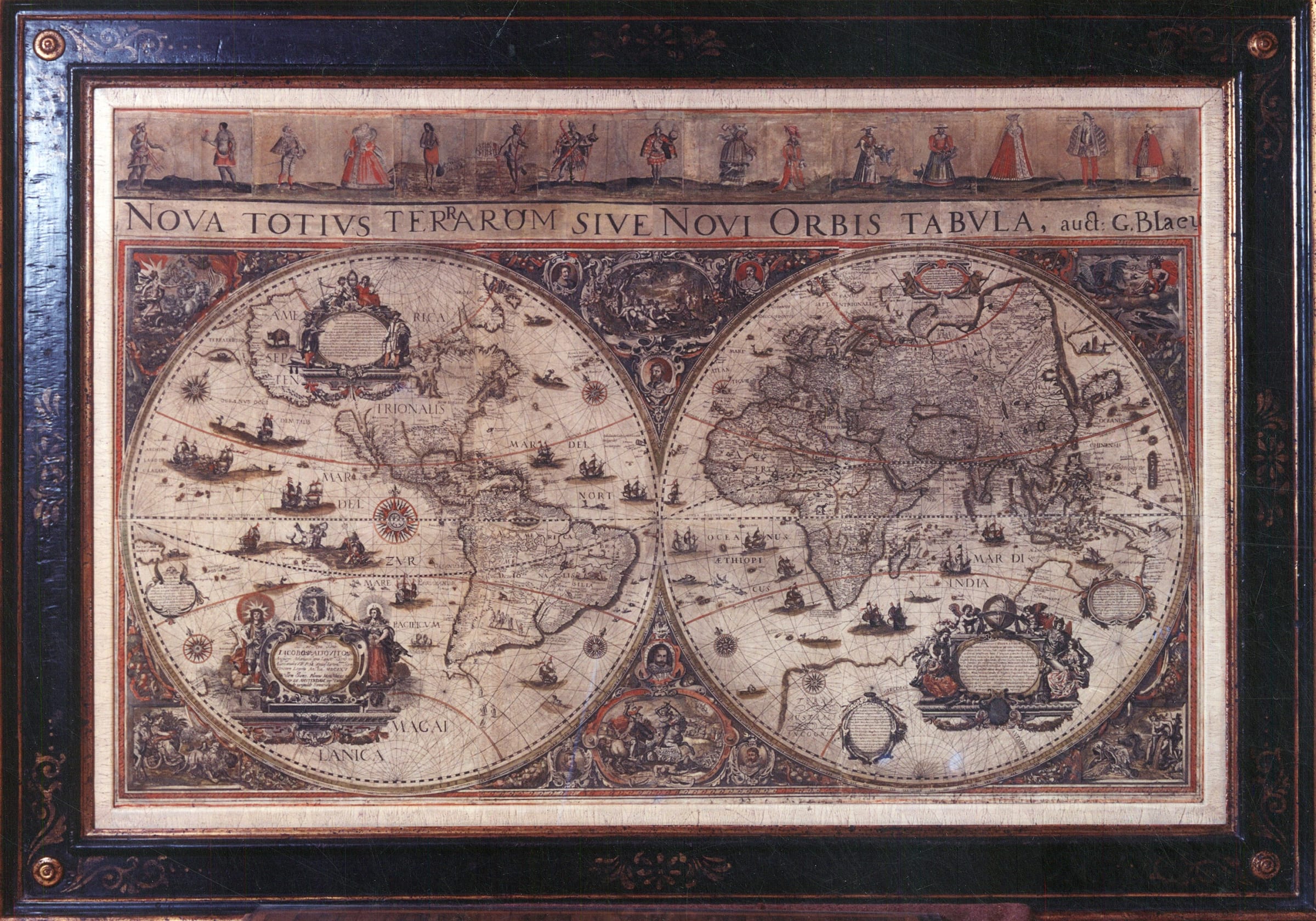
This exceedingly rare and spectacular piece is a magnificent example of a surviving 17th century wall map. Designed to awe the beholder with their beauty and decorative detail, wall maps...
This exceedingly rare and spectacular piece is a magnificent example of a surviving 17th century wall map. Designed to awe the beholder with their beauty and decorative detail, wall maps represent the pinnacle of the “Golden Age of Cartography”.
Despite being signed “G.Blaeu” in the title banner, the derivation and sources for this map are obscure, and even its author and place of publication are uncertain. Two of the five known examples of this map have upper borders incorporating royal equestrian figures, several of which are signed by the engraver, Stefano Scolari who was active in Venice in the 1660’s, and it seems probable that he was responsible for the masterly engraving of the whole map. While the map, like virtually all 17th century wall maps, is based on Blaeu’s wall map of 1605, it is a close copy of 1629 world map of Nicholaes van Wassenaer, of which only one surviving example is known. The inclusion of the name “G.Blaeu” is a graphic testament to his continuing attraction to potential map buyers even twenty-seven years after his death.
This map was designed to adorn the wall of a royal, noble or wealthy merchant patron, hence the emphasis placed on its magnificent decorative appeal. Each of the corners is filled with scenes representing the classical elements of Fire, Air, Earth and Water. Two leaf vignettes and six portraits of eminent explorers and circumnavigators dominate the central cusps. The vignettes contrast the very different Aurea Aetas, the Golden Age representing the mythical tranquillity of the past, with the current Ferrea Aetas, the Age of Iron, characterised by conflict and battle.
The decoration in the map itself is dominated by three large cartouches. One cartouche has a dedication to Jacobo Altovito, the papal ambassador to the Republic of Venice. It is surmounted by a cardinal’s coat of arms and flanked by imposing allegorical figures personifying the Sun and the Moon. The cartouche in North America shows two sailors, one navigating from an Atlas with a pair of compasses, the other preparing to swing a lead line. The third cartouche continues this theme with three female figures, two putti and a directing angel, all representing learning and the study of geography.
The main body of the map is made up of six large sheets joined. The upper border consists of fifteen costume figures representing the nobility and commoners of Africa, Europe, and the Americas above an engraved title of six joined pieces. The upper decorative border, unlike the title banner, differs in each of the recorded examples of this map. The example in the Munich State Library has no upper border, while two of the others include equestrian royal portraits celebrating the monarchs of Europe.
Both the title and the costume border are intriguing. All five known examples of this map have the same engraved title. That the title is copper-engraved rather than the less expensive woodcut is unusual in itself, but perhaps explains why the title was never corrected despite a glaring spelling error with the word “TERRARUM”. The engraver has spelt it “TERAROM” and has had to add another “R” and attempted to change the “O” into a “U” by adding arms!
There are only four other recorded examples of this marvellous map.
One uncoloured copy without the upper border is in the Bavarian State Library in Munich. Another copy with an equestrian upper border is believed to be in a private collection in Hungary. The Map House has handled one further unrecorded example, also with a variant costume border.
Original hand-colour. Framed.
[WLD3325]
Publications
Shirley (R.): The Mapping of the World, 435
Share
- Tumblr
Join our mailing list
* denotes required fields
We will process the personal data you have supplied to communicate with you in accordance with our Privacy Policy. You can unsubscribe or change your preferences at any time by clicking the link in our emails.
Contact
The Map House
54 Beauchamp Place,
London SW3 1NY,
United Kingdom
maps@themaphouse.com
+44 (0)20 7589 4325
![]()
Copyright © 2025 The Map House
This website uses cookies
This site uses cookies to help make it more useful to you. Please contact us to find out more about our Cookie Policy.