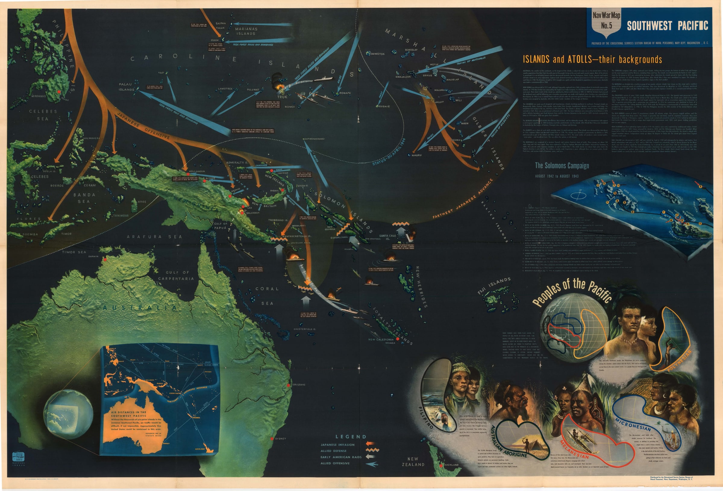
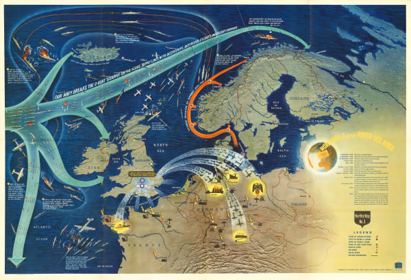
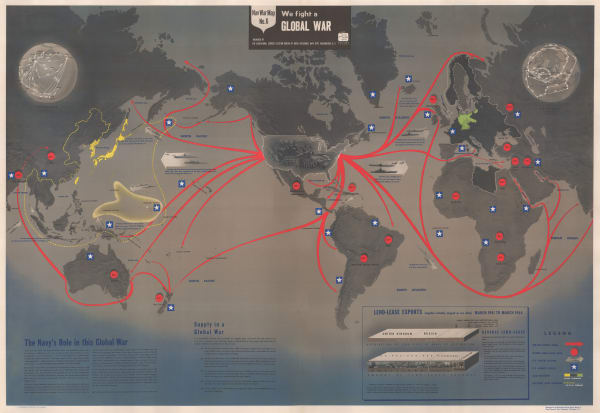
- All
- AFRICA
- ▪ Central Africa
- ▪ East Africa
- ▪ North Africa
- ▪ Southern Africa
- ▪ West Africa
- ▪ Atlantic Islands
- AMERICAS
-
▪ United States (USA)
- USA - East
- USA - Midwest
- USA - Northeast
- USA - Southeast
- USA - West & Southwest
- Alabama
- Alaska
- Arizona
- Arkansas
- California
- Colorado
- Connecticut
- Delaware
- Florida
- Georgia
- Hawaii
- Idaho
- Illinois
- Indiana
- Iowa
- Kansas
- Kentucky
- Louisiana
- Maine
- Maryland
- Massachusetts
- Michigan
- Minnesota
- Mississippi
- Missouri
- Montana
- Nebraska
- Nevada
- New Hampshire
- New Jersey
- New Mexico
- New York
- New York City
- North Carolina
- North Dakota
- Ohio
- Oklahoma
- Oregon
- Pennsylvania
- Rhode Island
- South Carolina
- South Dakota
- Tennessee
- Texas
- Utah
- Vermont
- Virginia
- Washington
- Washington, D.C.
- West Virginia
- Wisconsin
- Wyoming
- ▪ North America
- ▪ South America
- ▪ Caribbean
- ASIA
- ▪ East Asia
- ▪ Southeast Asia
- ▪ India & South Asia
- ▪ Middle East & Turkey
- BRITISH ISLES
- ▪ London
-
▪ England
- English Cities
- Bedfordshire
- Berkshire
- Buckinghamshire
- Cambridgeshire
- Cheshire
- Cornwall
- Cumbria
- Derbyshire
- Devon
- Dorset
- Durham
- Essex
- Gloucestershire
- Hampshire
- Herefordshire
- Hertfordshire
- Huntingdonshire
- Isle of Wight
- Kent
- Lancashire
- Leicestershire
- Lincolnshire
- Middlesex
- Norfolk
- Northamptonshire
- Northumberland
- Nottinghamshire
- Oxfordshire
- Rutland
- Shropshire
- Somerset
- Staffordshire
- Suffolk
- Surrey
- Sussex
- Warwickshire
- Wiltshire
- Worcestershire
- Yorkshire
- Yorkshire East Riding
- Yorkshire North Riding
- Yorkshire West Riding
- ▪ Ireland
- ▪ Scotland
- ▪ Wales
- EUROPE
- ▪ Austria & Switzerland
- ▪ Benelux Region
- ▪ Central & Eastern Europe
- ▪ France & Monaco
- ▪ Germany
- ▪ Greece
- ▪ Italy
- ▪ Mediterranean Sea
- ▪ Spain & Portugal
- ▪ Scandinavia & Baltics
- ▪ Russia, Ukraine & Caucasus
- OCEANIA
- ▪ Australia
- ▪ New Zealand
- ▪ Pacific Ocean & Islands
- ▪ Papua New Guinea
- POLAR
- CELESTIAL
- WORLD
- GLOBES & INSTRUMENTS
- THEMATIC
- COLLABORATIONS
US Navy Educational Services Section
WW2-era map of the Pacific, 1944
40 x 58 in
101.6 x 147.3 cm
101.6 x 147.3 cm
AUNZ2892
£ 3,000.00
US Navy Educational Services Section, WW2-era map of the Pacific, 1944
Sold
%3Cdiv%20class%3D%22artist%22%3EUS%20Navy%20Educational%20Services%20Section%3C/div%3E%3Cdiv%20class%3D%22title_and_year%22%3E%3Cspan%20class%3D%22title_and_year_title%22%3EWW2-era%20map%20of%20the%20Pacific%3C/span%3E%2C%20%3Cspan%20class%3D%22title_and_year_year%22%3E1944%3C/span%3E%3C/div%3E%3Cdiv%20class%3D%22dimensions%22%3E40%20x%2058%20in%3Cbr/%3E%0A101.6%20x%20147.3%20cm%3C/div%3E
Nav War Map No. 5 - Southwest Pacific This enormous WW2-era map of the Pacific was published by the US Navy's Educational Services Section to educate its troops about...
Nav War Map No. 5 - Southwest Pacific
This enormous WW2-era map of the Pacific was published by the US Navy's Educational Services Section to educate its troops about the geography, history, and people of the Pacific, and also to provide an update on the Allied campaign against the Japanese up to May 1944.
Orange arrows show Japanese attacks, while light orange shading shows the eastern limit of the Japanese advance. In contrast, blue arrows show Allied attacks, raids, and invasions, with the latest combat marked up to the end of April 1944. Paragraphs of text in the top-right corner describe each of the islands and atolls in the region, while another section below lists the key events of the Solomons Campaign, which lasted from August 1942 to August 1943.
In the lower-right corner is a crude explanation of the ethnic groups of the South Pacific, differentiating between Melanesia, Polynesia, Micronesia, Filipino, and Australian Aborigine populations. Another inset in the lower-left corner marks the air distances between island groups in the Southwest Pacific.
This map is part of a series of 6 educational posters designed by the US Navy to explain the various combat theatres in which American sailors and marines were fighting. Other maps in the series focus on the Mediterranean, the North Atlantic, the North Pacific, and the South China Sea. There is also a world map in the series.
All of these posters are not only educational, but are also extremely attractive and evocative. Sweeping multi-coloured arrows show Allied and Axis offensives and counter-offensives. Planes and ships, both in an out of combat, are often illustrated on the map to provide extra decoration. Terrain is drawn in relief as if on a 3-D model. Just enough facts and historical details are added to provide interest, but not so many as to make the posters overwhelming. In all, these are masterful examples of educational poster design which have hardly been rivalled since.
Printed colour. Laid down on archival linen. [Tube]
Share
- Tumblr
Related artworks
-
-
Nav War Map No. 6 - We Fight A Global War, 1944US Navy Educational Services SectionSeries: Washington, D.C.%3Cdiv%20class%3D%22title_and_year%22%3E%3Cspan%20class%3D%22title_and_year_title%22%3ENav%20War%20Map%20No.%206%20-%20We%20Fight%20A%20Global%20War%3C/span%3E%2C%20%3Cspan%20class%3D%22title_and_year_year%22%3E1944%3C/span%3E%3C/div%3E%3Cdiv%20class%3D%22artist%22%3EUS%20Navy%20Educational%20Services%20Section%3C/div%3E%3Cdiv%20class%3D%22series%22%3E%3Cspan%20class%3D%22artwork_caption_prefix%22%3ESeries%3A%3C/span%3E%20Washington%2C%20D.C.%3C/div%3EUS Navy Educational Services Section, Nav War Map No. 6 - We Fight A Global War, 1944Sold£ 2,200.00
Join our mailing list
* denotes required fields
We will process the personal data you have supplied to communicate with you in accordance with our Privacy Policy. You can unsubscribe or change your preferences at any time by clicking the link in our emails.
Contact
The Map House
54 Beauchamp Place,
London SW3 1NY,
United Kingdom
maps@themaphouse.com
+44 (0)20 7589 4325
Copyright © 2025 The Map House
This website uses cookies
This site uses cookies to help make it more useful to you. Please contact us to find out more about our Cookie Policy.