- All
- AFRICA
- ▪ Central Africa
- ▪ East Africa
- ▪ North Africa
- ▪ Southern Africa
- ▪ West Africa
- ▪ Atlantic Islands
- AMERICAS
-
▪ United States (USA)
- USA - East
- USA - Midwest
- USA - Northeast
- USA - Southeast
- USA - West & Southwest
- Alabama
- Alaska
- Arizona
- Arkansas
- California
- Colorado
- Connecticut
- Delaware
- Florida
- Georgia
- Hawaii
- Idaho
- Illinois
- Indiana
- Iowa
- Kansas
- Kentucky
- Louisiana
- Maine
- Maryland
- Massachusetts
- Michigan
- Minnesota
- Mississippi
- Missouri
- Montana
- Nebraska
- Nevada
- New Hampshire
- New Jersey
- New Mexico
- New York
- New York City
- North Carolina
- North Dakota
- Ohio
- Oklahoma
- Oregon
- Pennsylvania
- Rhode Island
- South Carolina
- South Dakota
- Tennessee
- Texas
- Utah
- Vermont
- Virginia
- Washington
- Washington, D.C.
- West Virginia
- Wisconsin
- Wyoming
- ▪ North America
- ▪ South America
- ▪ Caribbean
- ASIA
- ▪ East Asia
- ▪ Southeast Asia
- ▪ India & South Asia
- ▪ Middle East & Turkey
- BRITISH ISLES
- ▪ London
-
▪ England
- English Cities
- Bedfordshire
- Berkshire
- Buckinghamshire
- Cambridgeshire
- Cheshire
- Cornwall
- Cumbria
- Derbyshire
- Devon
- Dorset
- Durham
- Essex
- Gloucestershire
- Hampshire
- Herefordshire
- Hertfordshire
- Huntingdonshire
- Isle of Wight
- Kent
- Lancashire
- Leicestershire
- Lincolnshire
- Middlesex
- Norfolk
- Northamptonshire
- Northumberland
- Nottinghamshire
- Oxfordshire
- Rutland
- Shropshire
- Somerset
- Staffordshire
- Suffolk
- Surrey
- Sussex
- Warwickshire
- Wiltshire
- Worcestershire
- Yorkshire
- Yorkshire East Riding
- Yorkshire North Riding
- Yorkshire West Riding
- ▪ Ireland
- ▪ Scotland
- ▪ Wales
- EUROPE
- ▪ Austria & Switzerland
- ▪ Benelux Region
- ▪ Central & Eastern Europe
- ▪ France & Monaco
- ▪ Germany
- ▪ Greece
- ▪ Italy
- ▪ Mediterranean Sea
- ▪ Spain & Portugal
- ▪ Scandinavia & Baltics
- ▪ Russia, Ukraine & Caucasus
- OCEANIA
- ▪ Australia
- ▪ New Zealand
- ▪ Pacific Ocean & Islands
- ▪ Papua New Guinea
- POLAR
- CELESTIAL
- WORLD
- GLOBES & INSTRUMENTS
- THEMATIC
- COLLABORATIONS
Willem & Jan Blaeu
France, 1650 c.
16 x 20 ½ in
40 x 52 cm
40 x 52 cm
FR3553
£ 1,600.00
Willem & Jan Blaeu, France, 1650 c.
Sold
%3Cdiv%20class%3D%22artist%22%3EWillem%20%26%20Jan%20Blaeu%3C/div%3E%3Cdiv%20class%3D%22title_and_year%22%3E%3Cspan%20class%3D%22title_and_year_title%22%3EFrance%3C/span%3E%2C%20%3Cspan%20class%3D%22title_and_year_year%22%3E1650%20c.%3C/span%3E%3C/div%3E%3Cdiv%20class%3D%22dimensions%22%3E16%20x%2020%20%C2%BD%20in%3Cbr/%3E%0A40%20x%2052%20cm%3C/div%3E
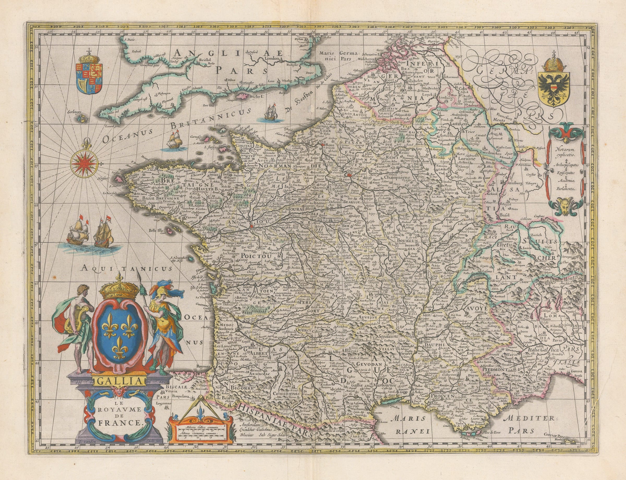
France. Embellished with ships and decorative cartouche. French text on verso. Blaeu’s map of France is an outstanding example of Golden Age Cartography. The was originally published with illustrated side...
France. Embellished with ships and decorative cartouche. French text on verso.
Blaeu’s map of France is an outstanding example of Golden Age Cartography. The was originally published with illustrated side borders in 1607 but by 1631, when Blaeu needed a map of France to add to his burgeoning atlas, this map was reduced in size by excluding the illustrated borders and added to the work.
Geographically, it is similar to the map by Mercator Hondius but both maps were published almost simultaneously. It is very likely that Blaeu used Mercator’s map as a model and then made small adjustments. Aesthetically the cartouche of the map is particularly fine, with two allegorical figures representing arts and war flanking a large depiction of the French royal coat of arms. The lower part of the pillar supporting the coat bears the name of the engraver, I. vanden Ende, one of Blaeu’s finest engravers. Blaeu discreetly adds his own name to the map under “Hispaniae” on the southern part of France.
There are also smaller coats of arms representing the Holy Roman Empire and Great Britain. This example of the map is one of the later issues with the addition of the name “Le Royaume de France” below the classical name “Gallia”.
Original colour. Latin text on reverse. Image available on request. [FR3553]
Share
- Tumblr
Join our mailing list
* denotes required fields
We will process the personal data you have supplied to communicate with you in accordance with our Privacy Policy. You can unsubscribe or change your preferences at any time by clicking the link in our emails.
Contact
The Map House
54 Beauchamp Place,
London SW3 1NY,
United Kingdom
maps@themaphouse.com
+44 (0)20 7589 4325
![]()
Copyright © 2025 The Map House
This website uses cookies
This site uses cookies to help make it more useful to you. Please contact us to find out more about our Cookie Policy.