- All
- AFRICA
- ▪ Central Africa
- ▪ East Africa
- ▪ North Africa
- ▪ Southern Africa
- ▪ West Africa
- ▪ Atlantic Islands
- AMERICAS
-
▪ United States (USA)
- USA - East
- USA - Midwest
- USA - Northeast
- USA - Southeast
- USA - West & Southwest
- Alabama
- Alaska
- Arizona
- Arkansas
- California
- Colorado
- Connecticut
- Delaware
- Florida
- Georgia
- Hawaii
- Idaho
- Illinois
- Indiana
- Iowa
- Kansas
- Kentucky
- Louisiana
- Maine
- Maryland
- Massachusetts
- Michigan
- Minnesota
- Mississippi
- Missouri
- Montana
- Nebraska
- Nevada
- New Hampshire
- New Jersey
- New Mexico
- New York
- New York City
- North Carolina
- North Dakota
- Ohio
- Oklahoma
- Oregon
- Pennsylvania
- Rhode Island
- South Carolina
- South Dakota
- Tennessee
- Texas
- Utah
- Vermont
- Virginia
- Washington
- Washington, D.C.
- West Virginia
- Wisconsin
- Wyoming
- ▪ North America
- ▪ South America
- ▪ Caribbean
- ASIA
- ▪ East Asia
- ▪ Southeast Asia
- ▪ India & South Asia
- ▪ Middle East & Turkey
- BRITISH ISLES
- ▪ London
-
▪ England
- English Cities
- Bedfordshire
- Berkshire
- Buckinghamshire
- Cambridgeshire
- Cheshire
- Cornwall
- Cumbria
- Derbyshire
- Devon
- Dorset
- Durham
- Essex
- Gloucestershire
- Hampshire
- Herefordshire
- Hertfordshire
- Huntingdonshire
- Isle of Wight
- Kent
- Lancashire
- Leicestershire
- Lincolnshire
- Middlesex
- Norfolk
- Northamptonshire
- Northumberland
- Nottinghamshire
- Oxfordshire
- Rutland
- Shropshire
- Somerset
- Staffordshire
- Suffolk
- Surrey
- Sussex
- Warwickshire
- Wiltshire
- Worcestershire
- Yorkshire
- Yorkshire East Riding
- Yorkshire North Riding
- Yorkshire West Riding
- ▪ Ireland
- ▪ Scotland
- ▪ Wales
- EUROPE
- ▪ Austria & Switzerland
- ▪ Benelux Region
- ▪ Central & Eastern Europe
- ▪ France & Monaco
- ▪ Germany
- ▪ Greece
- ▪ Italy
- ▪ Mediterranean Sea
- ▪ Spain & Portugal
- ▪ Scandinavia & Baltics
- ▪ Russia, Ukraine & Caucasus
- OCEANIA
- ▪ Australia
- ▪ New Zealand
- ▪ Pacific Ocean & Islands
- ▪ Papua New Guinea
- POLAR
- CELESTIAL
- WORLD
- GLOBES & INSTRUMENTS
- THEMATIC
- COLLABORATIONS
Jan van Brederode
25.4 x 27.9 cm
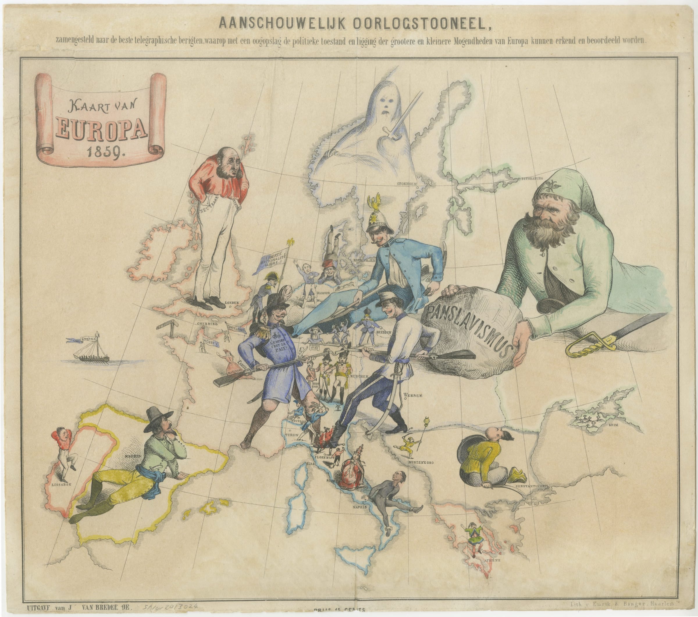
A rare Dutch caricature map of Europe satirising the political situation in 1859 during the Franco-Austrian War, also known as the Second Italian War of Independence . This is one of the earliest known examples of an anthropomorphic satire map.
The map's central figures are France (represented by Emperor Napoleon III) and Austria (possibly represented by General Ludwig von Benedek, second in command of the Austrian army under Emperor Franz Joseph I). The two nations are engaged in hand-to-hand combat with bayonets over northern Italy, the goal of the war. France had agreed to support the Kingdom of Sardinia's declaration of independence against Austria in exchange for the provinces of Savoy and Nice. The tiny figure of Sardinia can be seen waving a sabre from behind France's leg. Red-coated figures representing Italian revolutionaries also join in the fight by stabbing at Austria's foot. Elsewhere in Italy, the Pope looks on in horror at the prospect of Italian independence or unification, while Naples, represented as a prisoner in shackles, watches hopefully.
The other major nations of Europe are also pictured. Russia is a bearded giant pushing a boulder labelled 'Panslavism' which threatens to crush Austria and the rest of Europe. Britain is represented by the dour figure of Edward Smith-Stanley, Prime Minister at the time, who looks disapprovingly at Europe with his hands in his pockets which are labelled 'Neutral'. The seated figure of Emperor Wilhelm I represents Germany - his rifle is laid casually on his lap but also points rather unsubtly at France's chest, while his right foot is pressed against France's shoulder, knocking France slightly off balance. The Ottoman Empire is ignoring the conflict entirely, instead focusing on the Russian threat which the rest of Europe is too distracted to see. A recumbent Spain watches the action with interest, but little inclination to join, though a dagger in his belt suggests the possibility of combat if required. Scandinavia is a ghost with a sword, a reminder of the region's former fighting prowess, now replaced by neutrality.
The ephemeral nature of these satirical maps makes them inherently rare, but this one is especially so. Only three other examples of this map are known: one in private hands, one in the British Library, and one in the Rijksmuseum in Amsterdam.
Lithographed by the firm of Emrik & Binger. Printed colour. [EUR1514]
- X
- Tumblr
Join our mailing list
* denotes required fields
We will process the personal data you have supplied to communicate with you in accordance with our Privacy Policy. You can unsubscribe or change your preferences at any time by clicking the link in our emails.
Contact
The Map House
54 Beauchamp Place,
London SW3 1NY,
United Kingdom
maps@themaphouse.com
+44 (0)20 7589 4325
![]()
This website uses cookies
This site uses cookies to help make it more useful to you. Please contact us to find out more about our Cookie Policy.
Join our mailing list
* denotes required fields
We will process the personal data you have supplied to communicate with you in accordance with our Privacy Policy. You can unsubscribe or change your preferences at any time by clicking the link in our emails.