- All
- AFRICA
- ▪ Central Africa
- ▪ East Africa
- ▪ North Africa
- ▪ Southern Africa
- ▪ West Africa
- ▪ Atlantic Islands
- AMERICAS
-
▪ United States (USA)
- USA - East
- USA - Midwest
- USA - Northeast
- USA - Southeast
- USA - West & Southwest
- Alabama
- Alaska
- Arizona
- Arkansas
- California
- Colorado
- Connecticut
- Delaware
- Florida
- Georgia
- Hawaii
- Idaho
- Illinois
- Indiana
- Iowa
- Kansas
- Kentucky
- Louisiana
- Maine
- Maryland
- Massachusetts
- Michigan
- Minnesota
- Mississippi
- Missouri
- Montana
- Nebraska
- Nevada
- New Hampshire
- New Jersey
- New Mexico
- New York
- New York City
- North Carolina
- North Dakota
- Ohio
- Oklahoma
- Oregon
- Pennsylvania
- Rhode Island
- South Carolina
- South Dakota
- Tennessee
- Texas
- Utah
- Vermont
- Virginia
- Washington
- Washington, D.C.
- West Virginia
- Wisconsin
- Wyoming
- ▪ North America
- ▪ South America
- ▪ Caribbean
- ASIA
- ▪ East Asia
- ▪ Southeast Asia
- ▪ India & South Asia
- ▪ Middle East & Turkey
- BRITISH ISLES
- ▪ London
-
▪ England
- English Cities
- Bedfordshire
- Berkshire
- Buckinghamshire
- Cambridgeshire
- Cheshire
- Cornwall
- Cumbria
- Derbyshire
- Devon
- Dorset
- Durham
- Essex
- Gloucestershire
- Hampshire
- Herefordshire
- Hertfordshire
- Huntingdonshire
- Isle of Wight
- Kent
- Lancashire
- Leicestershire
- Lincolnshire
- Middlesex
- Norfolk
- Northamptonshire
- Northumberland
- Nottinghamshire
- Oxfordshire
- Rutland
- Shropshire
- Somerset
- Staffordshire
- Suffolk
- Surrey
- Sussex
- Warwickshire
- Wiltshire
- Worcestershire
- Yorkshire
- Yorkshire East Riding
- Yorkshire North Riding
- Yorkshire West Riding
- ▪ Ireland
- ▪ Scotland
- ▪ Wales
- EUROPE
- ▪ Austria & Switzerland
- ▪ Benelux Region
- ▪ Central & Eastern Europe
- ▪ France & Monaco
- ▪ Germany
- ▪ Greece
- ▪ Italy
- ▪ Mediterranean Sea
- ▪ Spain & Portugal
- ▪ Scandinavia & Baltics
- ▪ Russia, Ukraine & Caucasus
- OCEANIA
- ▪ Australia
- ▪ New Zealand
- ▪ Pacific Ocean & Islands
- ▪ Papua New Guinea
- POLAR
- CELESTIAL
- WORLD
- GLOBES & INSTRUMENTS
- THEMATIC
- COLLABORATIONS
Editions-G.D.
WWI French caricature map of Europe, 1915
18 ½ x 24 in
47 x 61 cm
47 x 61 cm
EUR1440
£ 4,500.00
Editions-G.D., WWI French caricature map of Europe, 1915
Sold
%3Cdiv%20class%3D%22artist%22%3EEditions-G.D.%3C/div%3E%3Cdiv%20class%3D%22title_and_year%22%3E%3Cspan%20class%3D%22title_and_year_title%22%3EWWI%20French%20caricature%20map%20of%20Europe%3C/span%3E%2C%20%3Cspan%20class%3D%22title_and_year_year%22%3E1915%3C/span%3E%3C/div%3E%3Cdiv%20class%3D%22dimensions%22%3E18%20%C2%BD%20x%2024%20in%3Cbr/%3E%0A47%20x%2061%20cm%3C/div%3E
Carte Symbolique De L'Europe French caricature map of Europe at the outbreak of the First World War in 1914. Drawn by B. Crété and published by Editions-G.D. in Paris....
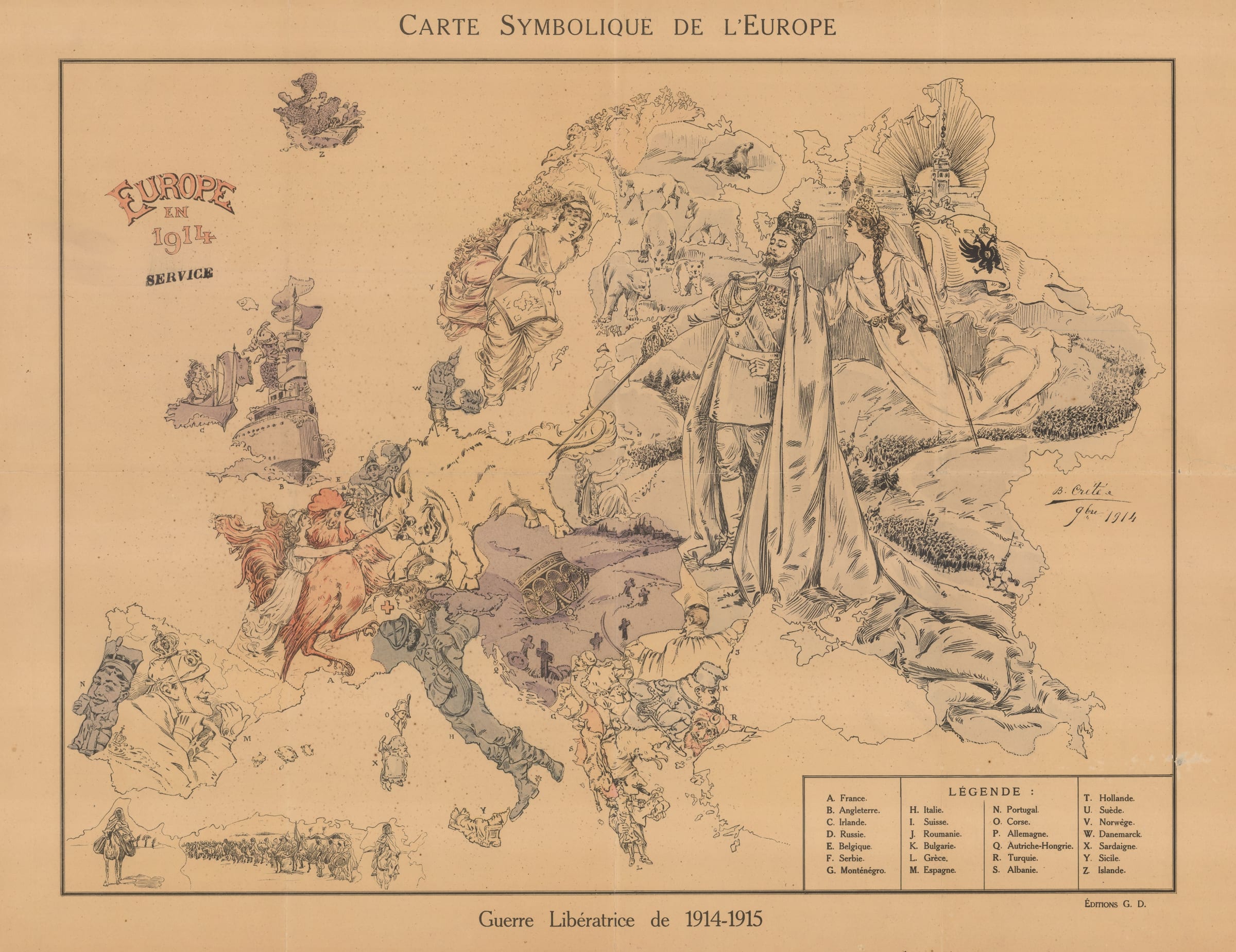
Carte Symbolique De L'Europe
French caricature map of Europe at the outbreak of the First World War in 1914. Drawn by B. Crété and published by Editions-G.D. in Paris.
This map is derived from an earlier Russian map drawn by the Polish artist Vladislav Levinsky in Warsaw. By portraying the Tsar as a powerful, liberating figure, Levinsky was able to obtain the approval of the Russian censors and get his work published. Tsar Nicholas stands triumphant at the head of his marching armies, casually prodding the Prussian bull with his sword, a suggestion that the war would be won with no effort whatsoever.
In the Balkans Russia's allies Serbia and Montenegro surge forward victoriously into Austria-Hungary which is depicted as a barren wasteland surrounding the fallen Habsburg crown.
France is represented in the form of Marianne, the lady of liberty, charging forward on an angry Gallic cockerel and poking the charging Prussian bull in the forehead. The figure of Britain meanwhile looks on from his battleship steaming at full speed towards Europe with Ireland in tow.
Italy, still a neutral power in 1914, strums his guitar and looks on slyly having refused Germany's call to arms at the beginning of the war. Portugal and Spain, neutral powers, watch the action from the sidelines, as do the Scandinavians.
Printed colour. [EUR1440]
Share
- Tumblr
Join our mailing list
* denotes required fields
We will process the personal data you have supplied to communicate with you in accordance with our Privacy Policy. You can unsubscribe or change your preferences at any time by clicking the link in our emails.
Contact
The Map House
54 Beauchamp Place,
London SW3 1NY,
United Kingdom
maps@themaphouse.com
+44 (0)20 7589 4325
![]()
Copyright © 2025 The Map House
This website uses cookies
This site uses cookies to help make it more useful to you. Please contact us to find out more about our Cookie Policy.