- All
- AFRICA
- ▪ Central Africa
- ▪ East Africa
- ▪ North Africa
- ▪ Southern Africa
- ▪ West Africa
- ▪ Atlantic Islands
- AMERICAS
-
▪ United States (USA)
- USA - East
- USA - Midwest
- USA - Northeast
- USA - Southeast
- USA - West & Southwest
- Alabama
- Alaska
- Arizona
- Arkansas
- California
- Colorado
- Connecticut
- Delaware
- Florida
- Georgia
- Hawaii
- Idaho
- Illinois
- Indiana
- Iowa
- Kansas
- Kentucky
- Louisiana
- Maine
- Maryland
- Massachusetts
- Michigan
- Minnesota
- Mississippi
- Missouri
- Montana
- Nebraska
- Nevada
- New Hampshire
- New Jersey
- New Mexico
- New York
- New York City
- North Carolina
- North Dakota
- Ohio
- Oklahoma
- Oregon
- Pennsylvania
- Rhode Island
- South Carolina
- South Dakota
- Tennessee
- Texas
- Utah
- Vermont
- Virginia
- Washington
- Washington, D.C.
- West Virginia
- Wisconsin
- Wyoming
- ▪ North America
- ▪ South America
- ▪ Caribbean
- ASIA
- ▪ East Asia
- ▪ Southeast Asia
- ▪ India & South Asia
- ▪ Middle East & Turkey
- BRITISH ISLES
- ▪ London
-
▪ England
- English Cities
- Bedfordshire
- Berkshire
- Buckinghamshire
- Cambridgeshire
- Cheshire
- Cornwall
- Cumbria
- Derbyshire
- Devon
- Dorset
- Durham
- Essex
- Gloucestershire
- Hampshire
- Herefordshire
- Hertfordshire
- Huntingdonshire
- Isle of Wight
- Kent
- Lancashire
- Leicestershire
- Lincolnshire
- Middlesex
- Norfolk
- Northamptonshire
- Northumberland
- Nottinghamshire
- Oxfordshire
- Rutland
- Shropshire
- Somerset
- Staffordshire
- Suffolk
- Surrey
- Sussex
- Warwickshire
- Wiltshire
- Worcestershire
- Yorkshire
- Yorkshire East Riding
- Yorkshire North Riding
- Yorkshire West Riding
- ▪ Ireland
- ▪ Scotland
- ▪ Wales
- EUROPE
- ▪ Austria & Switzerland
- ▪ Benelux Region
- ▪ Central & Eastern Europe
- ▪ France & Monaco
- ▪ Germany
- ▪ Greece
- ▪ Italy
- ▪ Mediterranean Sea
- ▪ Spain & Portugal
- ▪ Scandinavia & Baltics
- ▪ Russia, Ukraine & Caucasus
- OCEANIA
- ▪ Australia
- ▪ New Zealand
- ▪ Pacific Ocean & Islands
- ▪ Papua New Guinea
- POLAR
- CELESTIAL
- WORLD
- GLOBES & INSTRUMENTS
- THEMATIC
- COLLABORATIONS
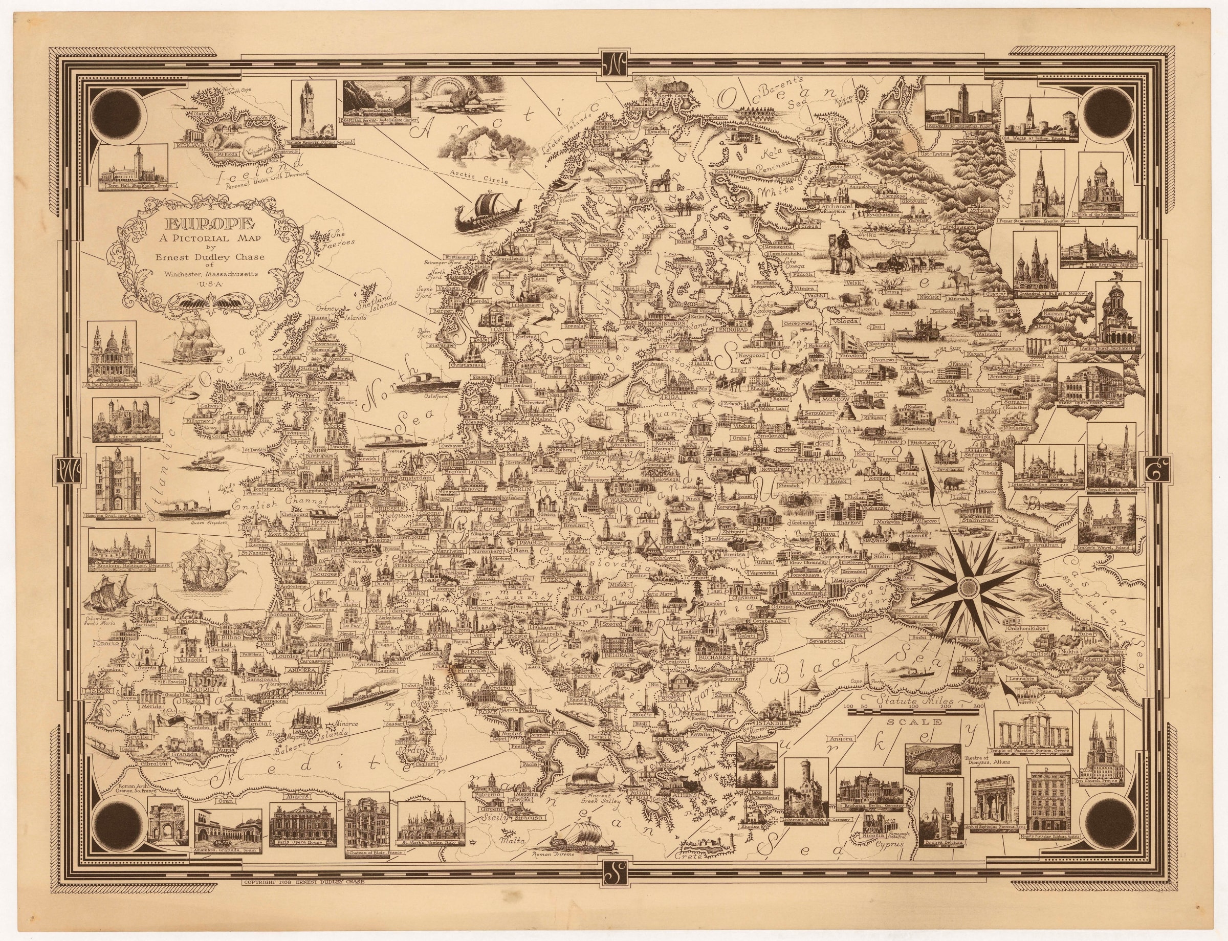
Ernest Dudley Chase
Europe - A Pictorial Map, 1938
17 1/2 x 23 1/2 in
45 x 60 cm
45 x 60 cm
EUR1432
£ 1,450.00
Ernest Dudley Chase, Europe - A Pictorial Map, 1938
Sold
%3Cdiv%20class%3D%22artist%22%3EErnest%20Dudley%20Chase%3C/div%3E%3Cdiv%20class%3D%22title_and_year%22%3E%3Cspan%20class%3D%22title_and_year_title%22%3EEurope%20-%20A%20Pictorial%20Map%3C/span%3E%2C%20%3Cspan%20class%3D%22title_and_year_year%22%3E1938%3C/span%3E%3C/div%3E%3Cdiv%20class%3D%22dimensions%22%3E17%201/2%20x%2023%201/2%20in%3Cbr/%3E%0A45%20x%2060%20cm%3C/div%3E
Pictorial map of Europe charmingly illustrated with hundreds of vignettes of important buildings, landmarks, and natural features. The major cities and towns are each represented by an important or iconic...
Pictorial map of Europe charmingly illustrated with hundreds of vignettes of important buildings, landmarks, and natural features. The major cities and towns are each represented by an important or iconic building, while whimsical illustrations of ships and animals fill the seas and empty spaces.
Laid down on archival linen. (SL) [EUR1432]
Ernest Dudley Chase
Ernest Dudley Chase (1878-1966), born in Lowell, Massachusetts, is one of the best known and prolific pictorial mapmakers of the 20th century. He created more than 50 different maps in his very distinctive style. A perfectionist, he is noted for his attention to fine details and for his illustrated vignettes. The maps frequently dealt humorously with serious subjects while always reflecting his passionate patriotism and optimism.
Many of his maps focus on his native New England, but he also designed maps of the world, Europe, North and South America, and WWII-themed maps. He published all of his maps from his home in Winchester, Massachusetts, taking orders from customers through the post. In a delightfully personal touch, he would sometimes sign his maps in pencil before dispatching them to customers.
Share
- Tumblr
Join our mailing list
* denotes required fields
We will process the personal data you have supplied to communicate with you in accordance with our Privacy Policy. You can unsubscribe or change your preferences at any time by clicking the link in our emails.
Contact
The Map House
54 Beauchamp Place,
London SW3 1NY,
United Kingdom
maps@themaphouse.com
+44 (0)20 7589 4325
![]()
Copyright © 2025 The Map House
This website uses cookies
This site uses cookies to help make it more useful to you. Please contact us to find out more about our Cookie Policy.