- All
- AFRICA
- ▪ Central Africa
- ▪ East Africa
- ▪ North Africa
- ▪ Southern Africa
- ▪ West Africa
- ▪ Atlantic Islands
- AMERICAS
-
▪ United States (USA)
- USA - East
- USA - Midwest
- USA - Northeast
- USA - Southeast
- USA - West & Southwest
- Alabama
- Alaska
- Arizona
- Arkansas
- California
- Colorado
- Connecticut
- Delaware
- Florida
- Georgia
- Hawaii
- Idaho
- Illinois
- Indiana
- Iowa
- Kansas
- Kentucky
- Louisiana
- Maine
- Maryland
- Massachusetts
- Michigan
- Minnesota
- Mississippi
- Missouri
- Montana
- Nebraska
- Nevada
- New Hampshire
- New Jersey
- New Mexico
- New York
- New York City
- North Carolina
- North Dakota
- Ohio
- Oklahoma
- Oregon
- Pennsylvania
- Rhode Island
- South Carolina
- South Dakota
- Tennessee
- Texas
- Utah
- Vermont
- Virginia
- Washington
- Washington, D.C.
- West Virginia
- Wisconsin
- Wyoming
- ▪ North America
- ▪ South America
- ▪ Caribbean
- ASIA
- ▪ East Asia
- ▪ Southeast Asia
- ▪ India & South Asia
- ▪ Middle East & Turkey
- BRITISH ISLES
- ▪ London
-
▪ England
- English Cities
- Bedfordshire
- Berkshire
- Buckinghamshire
- Cambridgeshire
- Cheshire
- Cornwall
- Cumbria
- Derbyshire
- Devon
- Dorset
- Durham
- Essex
- Gloucestershire
- Hampshire
- Herefordshire
- Hertfordshire
- Huntingdonshire
- Isle of Wight
- Kent
- Lancashire
- Leicestershire
- Lincolnshire
- Middlesex
- Norfolk
- Northamptonshire
- Northumberland
- Nottinghamshire
- Oxfordshire
- Rutland
- Shropshire
- Somerset
- Staffordshire
- Suffolk
- Surrey
- Sussex
- Warwickshire
- Wiltshire
- Worcestershire
- Yorkshire
- Yorkshire East Riding
- Yorkshire North Riding
- Yorkshire West Riding
- ▪ Ireland
- ▪ Scotland
- ▪ Wales
- EUROPE
- ▪ Austria & Switzerland
- ▪ Benelux Region
- ▪ Central & Eastern Europe
- ▪ France & Monaco
- ▪ Germany
- ▪ Greece
- ▪ Italy
- ▪ Mediterranean Sea
- ▪ Spain & Portugal
- ▪ Scandinavia & Baltics
- ▪ Russia, Ukraine & Caucasus
- OCEANIA
- ▪ Australia
- ▪ New Zealand
- ▪ Pacific Ocean & Islands
- ▪ Papua New Guinea
- POLAR
- CELESTIAL
- WORLD
- GLOBES & INSTRUMENTS
- THEMATIC
- COLLABORATIONS
Arthur B. Suchy
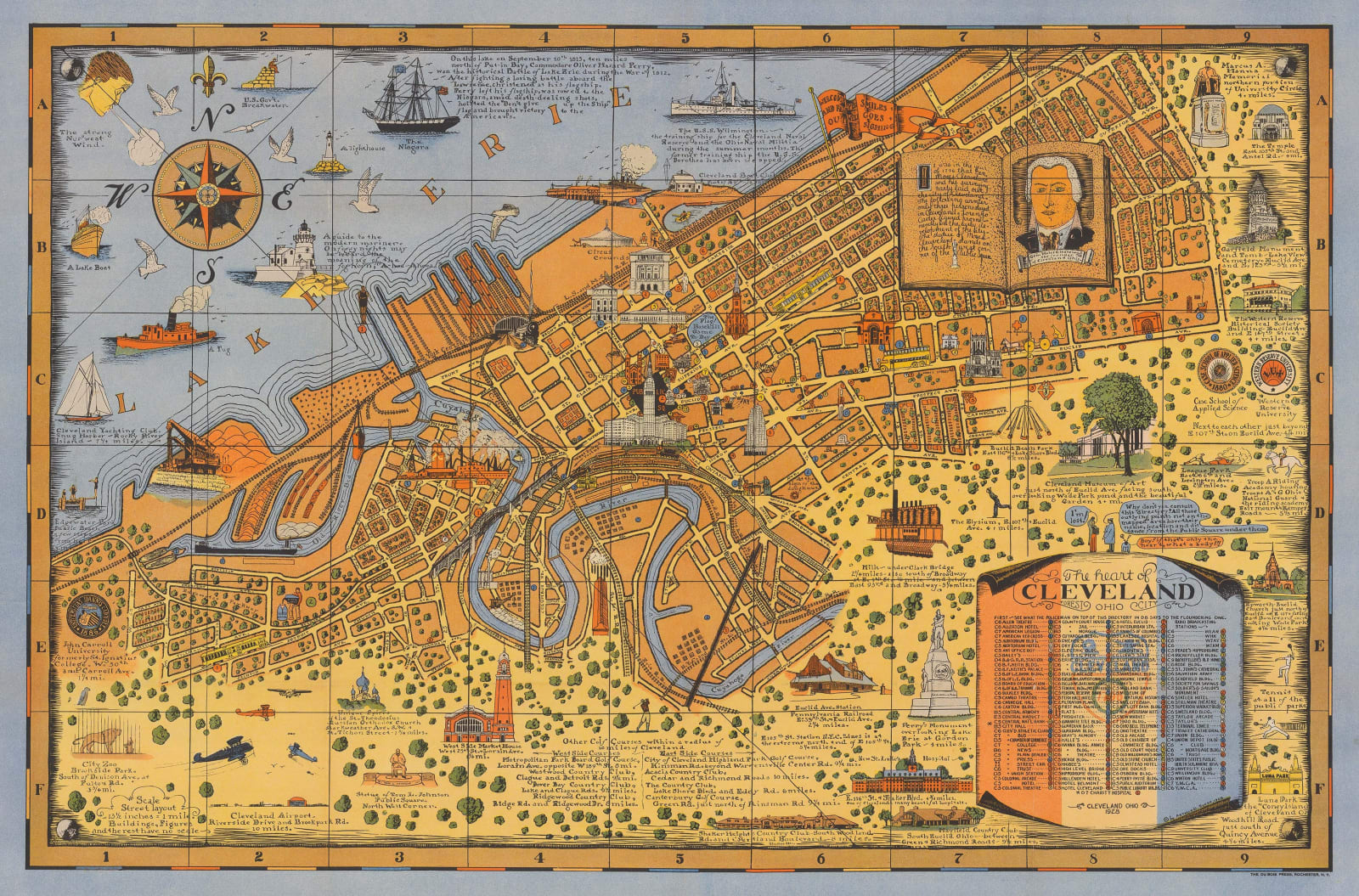
The Heart of Cleveland Ohio, 1928
25 ½ x 38 ½ in
65 x 98 cm
65 x 98 cm
USA9228
£ 495.00
Arthur B. Suchy, The Heart of Cleveland Ohio, 1928
Sold
%3Cdiv%20class%3D%22artist%22%3EArthur%20B.%20Suchy%3C/div%3E%3Cdiv%20class%3D%22title_and_year%22%3E%3Cspan%20class%3D%22title_and_year_title%22%3EThe%20Heart%20of%20Cleveland%20Ohio%3C/span%3E%2C%20%3Cspan%20class%3D%22title_and_year_year%22%3E1928%3C/span%3E%3C/div%3E%3Cdiv%20class%3D%22dimensions%22%3E25%20%C2%BD%20x%2038%20%C2%BD%20in%3Cbr/%3E%0A65%20x%2098%20cm%3C/div%3E
This large, vintage, pictorial map of Cleveland was published by local illustrator and cartographer, Arthur Suchy. It is rich with detail celebrating the city's unique character and history. The most...
This large, vintage, pictorial map of Cleveland was published by local illustrator and cartographer, Arthur Suchy. It is rich with detail celebrating the city's unique character and history. The most prominent landmark buildings are illustrated in relief, while coloured numbers mark lesser landmarks according to an index in the lower-right corner. Several interesting destinations which are located outside of the scope of the map, for example the airport and the City Zoo, are also illustrated and their distance from the city centre is given.
Arthur B. Suchy was born in Cleveland in 1901. He chose to study industrial design at Colgate University, attending from 1918-19. Alongside a traditional career as an industrial designer, Suchy created and published seven iconic pictorial maps. His first map was, appropriately, of his alma mater, Colgate University (1927), followed in the same year by a map of Swarthmore College. This large map of Cleveland was published in 1928 and shows a substantial development in Suchy's skill and confidence as an illustrator. In 1937, Suchy published a historical map of Cleveland showing the city as it looked 100 years earlier. A map celebrating the state of Ohio followed in 1939. Suchy's final two maps were dedicated not to his native Ohio, but rather to his adopted home in Florida. Maps of Miami and Key West were published in 1935 and 1940, respectively. Both are important records of these iconic tourist destinations during their golden ages.
Printed colour. [USA9228]
Share
- Tumblr
Join our mailing list
* denotes required fields
We will process the personal data you have supplied to communicate with you in accordance with our Privacy Policy. You can unsubscribe or change your preferences at any time by clicking the link in our emails.
Contact
The Map House
54 Beauchamp Place,
London SW3 1NY,
United Kingdom
maps@themaphouse.com
+44 (0)20 7589 4325

Copyright © 2025 The Map House
This website uses cookies
This site uses cookies to help make it more useful to you. Please contact us to find out more about our Cookie Policy.

