- All
- AFRICA
- ▪ Central Africa
- ▪ East Africa
- ▪ North Africa
- ▪ Southern Africa
- ▪ West Africa
- ▪ Atlantic Islands
- AMERICAS
-
▪ United States (USA)
- USA - East
- USA - Midwest
- USA - Northeast
- USA - Southeast
- USA - West & Southwest
- Alabama
- Alaska
- Arizona
- Arkansas
- California
- Colorado
- Connecticut
- Delaware
- Florida
- Georgia
- Hawaii
- Idaho
- Illinois
- Indiana
- Iowa
- Kansas
- Kentucky
- Louisiana
- Maine
- Maryland
- Massachusetts
- Michigan
- Minnesota
- Mississippi
- Missouri
- Montana
- Nebraska
- Nevada
- New Hampshire
- New Jersey
- New Mexico
- New York
- New York City
- North Carolina
- North Dakota
- Ohio
- Oklahoma
- Oregon
- Pennsylvania
- Rhode Island
- South Carolina
- South Dakota
- Tennessee
- Texas
- Utah
- Vermont
- Virginia
- Washington
- Washington, D.C.
- West Virginia
- Wisconsin
- Wyoming
- ▪ North America
- ▪ South America
- ▪ Caribbean
- ASIA
- ▪ East Asia
- ▪ Southeast Asia
- ▪ India & South Asia
- ▪ Middle East & Turkey
- BRITISH ISLES
- ▪ London
-
▪ England
- English Cities
- Bedfordshire
- Berkshire
- Buckinghamshire
- Cambridgeshire
- Cheshire
- Cornwall
- Cumbria
- Derbyshire
- Devon
- Dorset
- Durham
- Essex
- Gloucestershire
- Hampshire
- Herefordshire
- Hertfordshire
- Huntingdonshire
- Isle of Wight
- Kent
- Lancashire
- Leicestershire
- Lincolnshire
- Middlesex
- Norfolk
- Northamptonshire
- Northumberland
- Nottinghamshire
- Oxfordshire
- Rutland
- Shropshire
- Somerset
- Staffordshire
- Suffolk
- Surrey
- Sussex
- Warwickshire
- Wiltshire
- Worcestershire
- Yorkshire
- Yorkshire East Riding
- Yorkshire North Riding
- Yorkshire West Riding
- ▪ Ireland
- ▪ Scotland
- ▪ Wales
- EUROPE
- ▪ Austria & Switzerland
- ▪ Benelux Region
- ▪ Central & Eastern Europe
- ▪ France & Monaco
- ▪ Germany
- ▪ Greece
- ▪ Italy
- ▪ Mediterranean Sea
- ▪ Spain & Portugal
- ▪ Scandinavia & Baltics
- ▪ Russia, Ukraine & Caucasus
- OCEANIA
- ▪ Australia
- ▪ New Zealand
- ▪ Pacific Ocean & Islands
- ▪ Papua New Guinea
- POLAR
- CELESTIAL
- WORLD
- GLOBES & INSTRUMENTS
- THEMATIC
- COLLABORATIONS
John Speed
Merionethshire, 1614
15 x 19 ½ in
38 x 50 cm
38 x 50 cm
WCTS1359
£ 925.00
John Speed, Merionethshire, 1614
Sold
%3Cdiv%20class%3D%22artist%22%3EJohn%20Speed%3C/div%3E%3Cdiv%20class%3D%22title_and_year%22%3E%3Cspan%20class%3D%22title_and_year_title%22%3EMerionethshire%3C/span%3E%2C%20%3Cspan%20class%3D%22title_and_year_year%22%3E1614%3C/span%3E%3C/div%3E%3Cdiv%20class%3D%22dimensions%22%3E15%20x%2019%20%C2%BD%20in%3Cbr/%3E%0A38%20x%2050%20cm%3C/div%3E
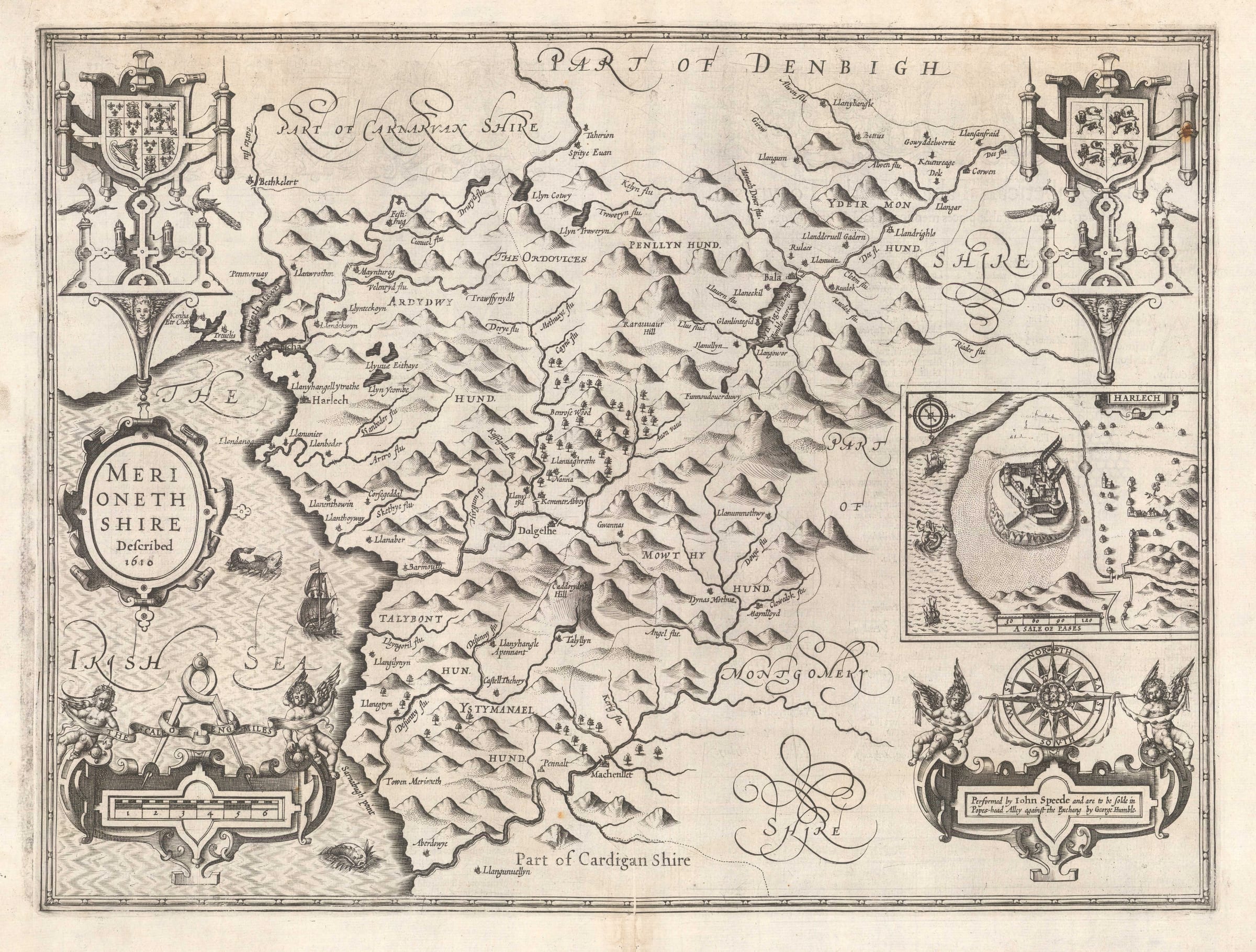
Merioneth. A fine map of the county from the second edition of Speed's seminal atlas, 'The Theatre of Great Britaine'. Vignette of Harlech. Merionethshire is one of the oldest counties...
Merioneth. A fine map of the county from the second edition of Speed's seminal atlas, 'The Theatre of Great Britaine'. Vignette of Harlech.
Merionethshire is one of the oldest counties established in Wales. It is also one of the poorest, least arable and therefore least populated regions in the country. It is extremely hilly, with steep cliff drops to the sea. What farming and industry there is mainly consists of either livestock farming and fishing although during the early 17th century, these were mostly at subsistence level.
Speed accurately portrays the topography of the region, marking the country with continuous hills, and little else. All the settlements are shown as very small. Speed visited the county during his travels in Wales and remarked upon its poverty. This is further emphasized by the one inset of a settlement on the map.
Unusually situated on the centre right edge, Speed illustrates the county town, Harlech. The image is dominated by the 13th century castle, with a few small houses and a rather desolate chapel, which Speed described as "neglected and without use".
Aesthetically, the map is quite strong, with the upper corners being adorned with coats of arms while the lower corners show an elaborate scale on the left and a compass rose together with a medallion stating Speed as the author of the map. The sea shows a ship and a couple of sea monsters.
English text on verso. Image available on request.
[WCTS1359]
Share
- Tumblr
Join our mailing list
* denotes required fields
We will process the personal data you have supplied to communicate with you in accordance with our Privacy Policy. You can unsubscribe or change your preferences at any time by clicking the link in our emails.
Contact
The Map House
54 Beauchamp Place,
London SW3 1NY,
United Kingdom
maps@themaphouse.com
+44 (0)20 7589 4325
![]()
Copyright © 2025 The Map House
This website uses cookies
This site uses cookies to help make it more useful to you. Please contact us to find out more about our Cookie Policy.