- All
- AFRICA
- ▪ Central Africa
- ▪ East Africa
- ▪ North Africa
- ▪ Southern Africa
- ▪ West Africa
- ▪ Atlantic Islands
- AMERICAS
-
▪ United States (USA)
- USA - East
- USA - Midwest
- USA - Northeast
- USA - Southeast
- USA - West & Southwest
- Alabama
- Alaska
- Arizona
- Arkansas
- California
- Colorado
- Connecticut
- Delaware
- Florida
- Georgia
- Hawaii
- Idaho
- Illinois
- Indiana
- Iowa
- Kansas
- Kentucky
- Louisiana
- Maine
- Maryland
- Massachusetts
- Michigan
- Minnesota
- Mississippi
- Missouri
- Montana
- Nebraska
- Nevada
- New Hampshire
- New Jersey
- New Mexico
- New York
- New York City
- North Carolina
- North Dakota
- Ohio
- Oklahoma
- Oregon
- Pennsylvania
- Rhode Island
- South Carolina
- South Dakota
- Tennessee
- Texas
- Utah
- Vermont
- Virginia
- Washington
- Washington, D.C.
- West Virginia
- Wisconsin
- Wyoming
- ▪ North America
- ▪ South America
- ▪ Caribbean
- ASIA
- ▪ East Asia
- ▪ Southeast Asia
- ▪ India & South Asia
- ▪ Middle East & Turkey
- BRITISH ISLES
- ▪ London
-
▪ England
- English Cities
- Bedfordshire
- Berkshire
- Buckinghamshire
- Cambridgeshire
- Cheshire
- Cornwall
- Cumbria
- Derbyshire
- Devon
- Dorset
- Durham
- Essex
- Gloucestershire
- Hampshire
- Herefordshire
- Hertfordshire
- Huntingdonshire
- Isle of Wight
- Kent
- Lancashire
- Leicestershire
- Lincolnshire
- Middlesex
- Norfolk
- Northamptonshire
- Northumberland
- Nottinghamshire
- Oxfordshire
- Rutland
- Shropshire
- Somerset
- Staffordshire
- Suffolk
- Surrey
- Sussex
- Warwickshire
- Wiltshire
- Worcestershire
- Yorkshire
- Yorkshire East Riding
- Yorkshire North Riding
- Yorkshire West Riding
- ▪ Ireland
- ▪ Scotland
- ▪ Wales
- EUROPE
- ▪ Austria & Switzerland
- ▪ Benelux Region
- ▪ Central & Eastern Europe
- ▪ France & Monaco
- ▪ Germany
- ▪ Greece
- ▪ Italy
- ▪ Mediterranean Sea
- ▪ Spain & Portugal
- ▪ Scandinavia & Baltics
- ▪ Russia, Ukraine & Caucasus
- OCEANIA
- ▪ Australia
- ▪ New Zealand
- ▪ Pacific Ocean & Islands
- ▪ Papua New Guinea
- POLAR
- CELESTIAL
- WORLD
- GLOBES & INSTRUMENTS
- THEMATIC
- COLLABORATIONS
John Speed
Penbrokshyre, 1614
15 x 20 in
38 x 51 cm
38 x 51 cm
WCTS1354
£ 1,450.00
John Speed, Penbrokshyre, 1614
Sold
%3Cdiv%20class%3D%22artist%22%3EJohn%20Speed%3C/div%3E%3Cdiv%20class%3D%22title_and_year%22%3E%3Cspan%20class%3D%22title_and_year_title%22%3EPenbrokshyre%3C/span%3E%2C%20%3Cspan%20class%3D%22title_and_year_year%22%3E1614%3C/span%3E%3C/div%3E%3Cdiv%20class%3D%22dimensions%22%3E15%20x%2020%20in%3Cbr/%3E%0A38%20x%2051%20cm%3C/div%3E
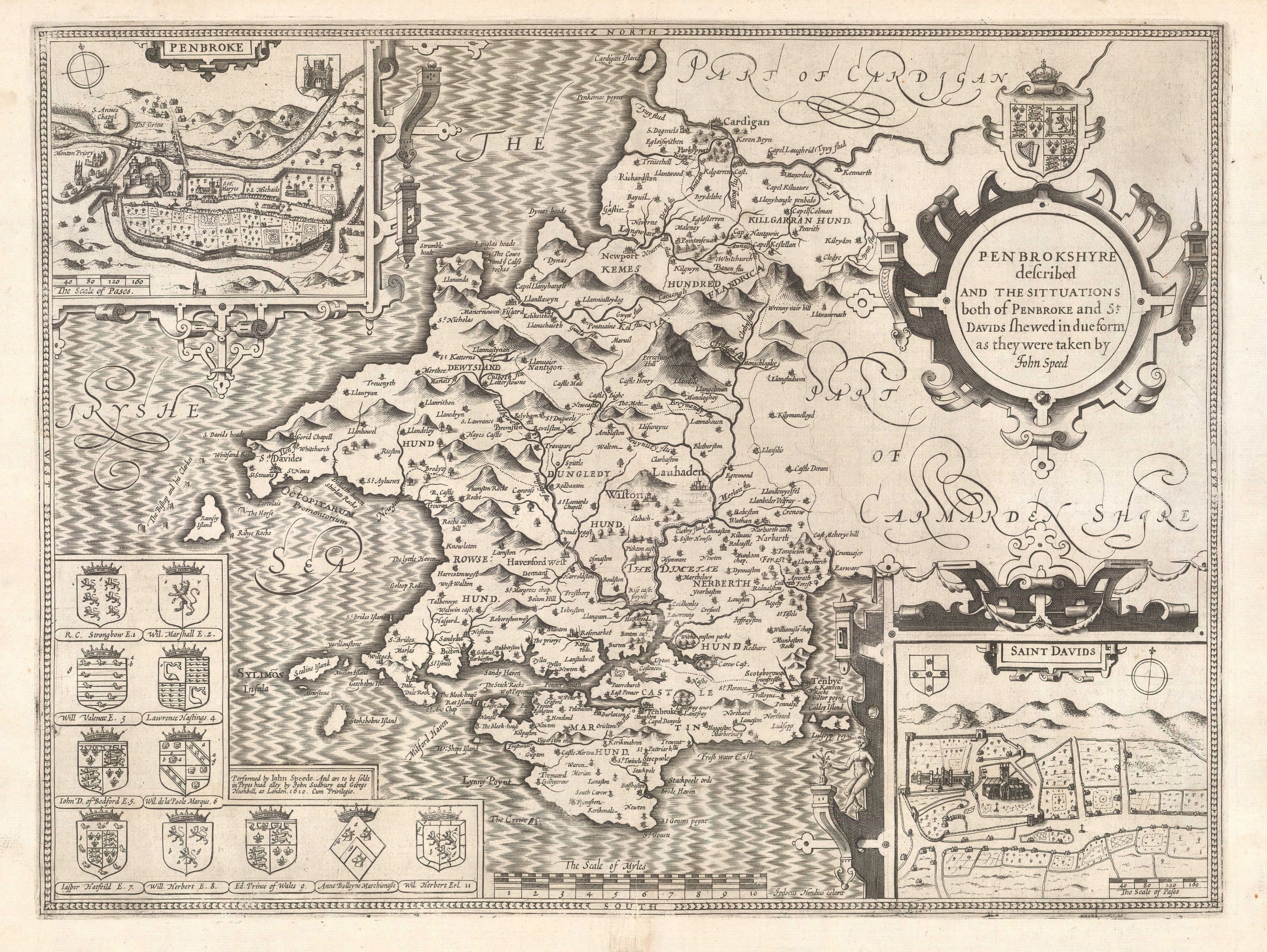
Pembroke. A fine map of the county from the second edition of Speed's seminal atlas, 'The Theatre of Great Britaine'. Vignette of Pembroke. One of the more spectacular maps of...
Pembroke. A fine map of the county from the second edition of Speed's seminal atlas, 'The Theatre of Great Britaine'. Vignette of Pembroke.
One of the more spectacular maps of the Welsh section of Speed's atlas is this map of Pembrokeshire, with its large "sugar" mountains, two insets and extensive coastline.
Geographically, it was based on Christopher Saxton's map although Speed is known to have travelled to the county to survey both the towns of Pembroke and St. David's. The former was the main population centre of the county and the latter was famous for being the supposed burial place of St. David, patron saint of Wales. Pembroke was also the birth place of Henry VII, founder of the Tudor dynasty, so it was certainly important enough to warrant a visit by Speed.
Pembrokeshire is one of the few maps on which Speed places two city plans, Pembroke and St. David's as mentioned above. He also places a series of heraldic shields on the lower left corner mainly on the sea, which leaves little room for his characteristic galleons and sea monsters. He does add one curious feature in the sea on the left centre of the map: a set of rocks named "The Bishop and his Clerkes" which today are known as the Bishop and Clerk Islands, a series of small reefs, rocks and islets which were notoriously dangerous to mariners.
English text on verso. Image available on request.
[WCTS1354]
Share
- Tumblr
Join our mailing list
* denotes required fields
We will process the personal data you have supplied to communicate with you in accordance with our Privacy Policy. You can unsubscribe or change your preferences at any time by clicking the link in our emails.
Contact
The Map House
54 Beauchamp Place,
London SW3 1NY,
United Kingdom
maps@themaphouse.com
+44 (0)20 7589 4325
![]()
Copyright © 2025 The Map House
This website uses cookies
This site uses cookies to help make it more useful to you. Please contact us to find out more about our Cookie Policy.