- All
- AFRICA
- ▪ Central Africa
- ▪ East Africa
- ▪ North Africa
- ▪ Southern Africa
- ▪ West Africa
- ▪ Atlantic Islands
- AMERICAS
-
▪ United States (USA)
- USA - East
- USA - Midwest
- USA - Northeast
- USA - Southeast
- USA - West & Southwest
- Alabama
- Alaska
- Arizona
- Arkansas
- California
- Colorado
- Connecticut
- Delaware
- Florida
- Georgia
- Hawaii
- Idaho
- Illinois
- Indiana
- Iowa
- Kansas
- Kentucky
- Louisiana
- Maine
- Maryland
- Massachusetts
- Michigan
- Minnesota
- Mississippi
- Missouri
- Montana
- Nebraska
- Nevada
- New Hampshire
- New Jersey
- New Mexico
- New York
- New York City
- North Carolina
- North Dakota
- Ohio
- Oklahoma
- Oregon
- Pennsylvania
- Rhode Island
- South Carolina
- South Dakota
- Tennessee
- Texas
- Utah
- Vermont
- Virginia
- Washington
- Washington, D.C.
- West Virginia
- Wisconsin
- Wyoming
- ▪ North America
- ▪ South America
- ▪ Caribbean
- ASIA
- ▪ East Asia
- ▪ Southeast Asia
- ▪ India & South Asia
- ▪ Middle East & Turkey
- BRITISH ISLES
- ▪ London
-
▪ England
- English Cities
- Bedfordshire
- Berkshire
- Buckinghamshire
- Cambridgeshire
- Cheshire
- Cornwall
- Cumbria
- Derbyshire
- Devon
- Dorset
- Durham
- Essex
- Gloucestershire
- Hampshire
- Herefordshire
- Hertfordshire
- Huntingdonshire
- Isle of Wight
- Kent
- Lancashire
- Leicestershire
- Lincolnshire
- Middlesex
- Norfolk
- Northamptonshire
- Northumberland
- Nottinghamshire
- Oxfordshire
- Rutland
- Shropshire
- Somerset
- Staffordshire
- Suffolk
- Surrey
- Sussex
- Warwickshire
- Wiltshire
- Worcestershire
- Yorkshire
- Yorkshire East Riding
- Yorkshire North Riding
- Yorkshire West Riding
- ▪ Ireland
- ▪ Scotland
- ▪ Wales
- EUROPE
- ▪ Austria & Switzerland
- ▪ Benelux Region
- ▪ Central & Eastern Europe
- ▪ France & Monaco
- ▪ Germany
- ▪ Greece
- ▪ Italy
- ▪ Mediterranean Sea
- ▪ Spain & Portugal
- ▪ Scandinavia & Baltics
- ▪ Russia, Ukraine & Caucasus
- OCEANIA
- ▪ Australia
- ▪ New Zealand
- ▪ Pacific Ocean & Islands
- ▪ Papua New Guinea
- POLAR
- CELESTIAL
- WORLD
- GLOBES & INSTRUMENTS
- THEMATIC
- COLLABORATIONS
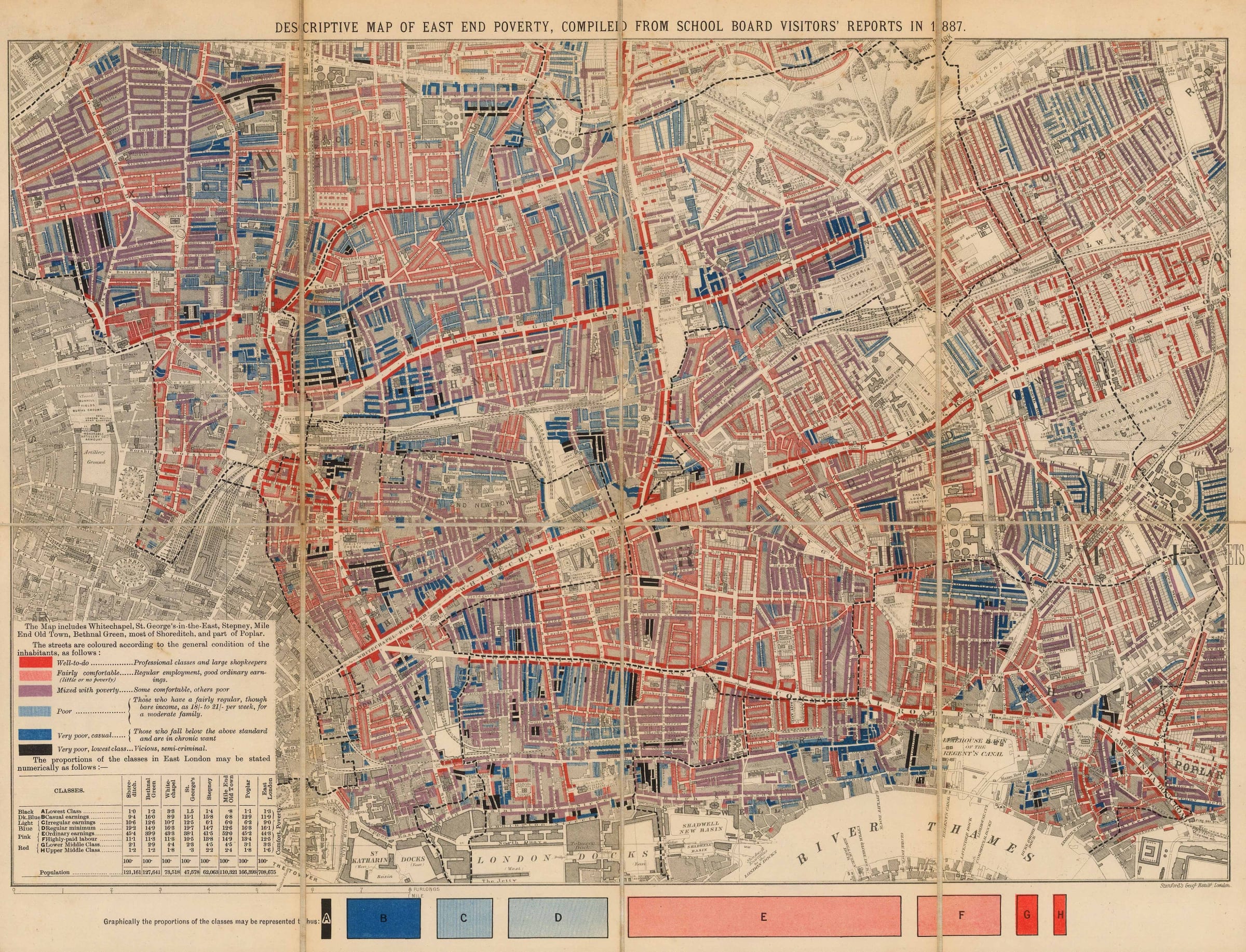
Charles Booth
38 x 48 cm
This rare folding map of the East End of London is an example of the very first poverty map published by Charles Booth. It appeared in the first edition of Life and Labour of the People of London. The map shows parts of Whitechapel, Bethnal Green, Limehouse, Wapping, Hoxton, and Shoreditch, the poorest part of London at the end of the 19th century. Booth chose to begin his survey here as it would most clearly show the deprivation suffered by a large percentage of London's residents.
A key in the lower-left corner explains that red areas are more comfortable, while blue and black areas are in mild or severe poverty. The colour scale below the map cleverly shows the percentage of the population in each wealth class, revealing the shocking truth that almost a third of residents of the East End were living in poverty.
Printed colour. Framed. [LDN5964]
- X
- Tumblr
Join our mailing list
* denotes required fields
We will process the personal data you have supplied to communicate with you in accordance with our Privacy Policy. You can unsubscribe or change your preferences at any time by clicking the link in our emails.
Contact
The Map House
54 Beauchamp Place,
London SW3 1NY,
United Kingdom
maps@themaphouse.com
+44 (0)20 7589 4325
![]()
This website uses cookies
This site uses cookies to help make it more useful to you. Please contact us to find out more about our Cookie Policy.
Join our mailing list
* denotes required fields
We will process the personal data you have supplied to communicate with you in accordance with our Privacy Policy. You can unsubscribe or change your preferences at any time by clicking the link in our emails.