- All
- AFRICA
- ▪ Central Africa
- ▪ East Africa
- ▪ North Africa
- ▪ Southern Africa
- ▪ West Africa
- ▪ Atlantic Islands
- AMERICAS
-
▪ United States (USA)
- USA - East
- USA - Midwest
- USA - Northeast
- USA - Southeast
- USA - West & Southwest
- Alabama
- Alaska
- Arizona
- Arkansas
- California
- Colorado
- Connecticut
- Delaware
- Florida
- Georgia
- Hawaii
- Idaho
- Illinois
- Indiana
- Iowa
- Kansas
- Kentucky
- Louisiana
- Maine
- Maryland
- Massachusetts
- Michigan
- Minnesota
- Mississippi
- Missouri
- Montana
- Nebraska
- Nevada
- New Hampshire
- New Jersey
- New Mexico
- New York
- New York City
- North Carolina
- North Dakota
- Ohio
- Oklahoma
- Oregon
- Pennsylvania
- Rhode Island
- South Carolina
- South Dakota
- Tennessee
- Texas
- Utah
- Vermont
- Virginia
- Washington
- Washington, D.C.
- West Virginia
- Wisconsin
- Wyoming
- ▪ North America
- ▪ South America
- ▪ Caribbean
- ASIA
- ▪ East Asia
- ▪ Southeast Asia
- ▪ India & South Asia
- ▪ Middle East & Turkey
- BRITISH ISLES
- ▪ London
-
▪ England
- English Cities
- Bedfordshire
- Berkshire
- Buckinghamshire
- Cambridgeshire
- Cheshire
- Cornwall
- Cumbria
- Derbyshire
- Devon
- Dorset
- Durham
- Essex
- Gloucestershire
- Hampshire
- Herefordshire
- Hertfordshire
- Huntingdonshire
- Isle of Wight
- Kent
- Lancashire
- Leicestershire
- Lincolnshire
- Middlesex
- Norfolk
- Northamptonshire
- Northumberland
- Nottinghamshire
- Oxfordshire
- Rutland
- Shropshire
- Somerset
- Staffordshire
- Suffolk
- Surrey
- Sussex
- Warwickshire
- Wiltshire
- Worcestershire
- Yorkshire
- Yorkshire East Riding
- Yorkshire North Riding
- Yorkshire West Riding
- ▪ Ireland
- ▪ Scotland
- ▪ Wales
- EUROPE
- ▪ Austria & Switzerland
- ▪ Benelux Region
- ▪ Central & Eastern Europe
- ▪ France & Monaco
- ▪ Germany
- ▪ Greece
- ▪ Italy
- ▪ Mediterranean Sea
- ▪ Spain & Portugal
- ▪ Scandinavia & Baltics
- ▪ Russia, Ukraine & Caucasus
- OCEANIA
- ▪ Australia
- ▪ New Zealand
- ▪ Pacific Ocean & Islands
- ▪ Papua New Guinea
- POLAR
- CELESTIAL
- WORLD
- GLOBES & INSTRUMENTS
- THEMATIC
- COLLABORATIONS
Herman Moll
71.1 x 119.4 cm
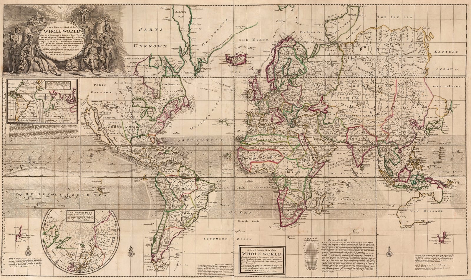
This monumental piece is the second world map in the "World Describ'd" the first being in the form of a double hemisphere and engraved in 1709. This version is on Mercator's projection and bears an engraving date of 1719 although that date remains unchanged in subsequent editions.
Geographically, the map is based on a collection of sources, including Moll's own earlier map of the world published in 1705 based on Edward Wright's projection. On that map, there is also a note stating that it was improved by Mount and Page. Other sources include the hydrological information within the two tropics provided by the voyage of Sir Edmund Halley and the privateer Woodes Rogers, whose voyage is marked on the Pacific.
Despite obvious exceptions such as portraying California as an island, Moll's map is remarkably accurate for its time. The rest of the American West is still fairly conjectural although Lahontan's mythical River of the West is prominently marked. The Far East is still mostly based on Dutch sources and the eastern shore of Asia and Tartary is based on Nicolas Witsen with the exception of a peculiar spur of land north of Japan which is bordered by another myth, Company's Land, supposedly discovered and claimed by Martin de Vries in 1643 on behalf of the Dutch East India Company. Africa is generally based on the shape first issued by de L'Isle and Australia is in the orthodox configuration as depicted by Blaeu, showing the outline of the continent except for the eastern coast which would not be discovered for another fifty years by Captain Cook.
Moll's map is given further gravitas by the routes of voyages of important explorers such as Henry Hudson, Thomas James and Willem Barentz and more recently, the above mentioned Rogers, who was one of the great celebrity navigators in the country at the time. A large illustrated cartouche is placed on the upper left, with four allegorical figures of the continents placed around a central panel which both introduces the map and, in typical Moll style, lists its features and virtues. The engraving date of 1719 is placed at the bottom.
Both this map and "The World Describ'd" helped establish Moll as the leading geographer of his age and encouraged other individuals into the trade, ultimately helping to usher English cartography into unparalleled success and importance in the late 18th century. Original colour.
[WLD3765]
- X
- Tumblr
Join our mailing list
* denotes required fields
We will process the personal data you have supplied to communicate with you in accordance with our Privacy Policy. You can unsubscribe or change your preferences at any time by clicking the link in our emails.
Contact
The Map House
54 Beauchamp Place,
London SW3 1NY,
United Kingdom
maps@themaphouse.com
+44 (0)20 7589 4325

This website uses cookies
This site uses cookies to help make it more useful to you. Please contact us to find out more about our Cookie Policy.
Join our mailing list
* denotes required fields
We will process the personal data you have supplied to communicate with you in accordance with our Privacy Policy. You can unsubscribe or change your preferences at any time by clicking the link in our emails.

