- All
- AFRICA
- ▪ Central Africa
- ▪ East Africa
- ▪ North Africa
- ▪ Southern Africa
- ▪ West Africa
- ▪ Atlantic Islands
- AMERICAS
-
▪ United States (USA)
- USA - East
- USA - Midwest
- USA - Northeast
- USA - Southeast
- USA - West & Southwest
- Alabama
- Alaska
- Arizona
- Arkansas
- California
- Colorado
- Connecticut
- Delaware
- Florida
- Georgia
- Hawaii
- Idaho
- Illinois
- Indiana
- Iowa
- Kansas
- Kentucky
- Louisiana
- Maine
- Maryland
- Massachusetts
- Michigan
- Minnesota
- Mississippi
- Missouri
- Montana
- Nebraska
- Nevada
- New Hampshire
- New Jersey
- New Mexico
- New York
- New York City
- North Carolina
- North Dakota
- Ohio
- Oklahoma
- Oregon
- Pennsylvania
- Rhode Island
- South Carolina
- South Dakota
- Tennessee
- Texas
- Utah
- Vermont
- Virginia
- Washington
- Washington, D.C.
- West Virginia
- Wisconsin
- Wyoming
- ▪ North America
- ▪ South America
- ▪ Caribbean
- ASIA
- ▪ East Asia
- ▪ Southeast Asia
- ▪ India & South Asia
- ▪ Middle East & Turkey
- BRITISH ISLES
- ▪ London
-
▪ England
- English Cities
- Bedfordshire
- Berkshire
- Buckinghamshire
- Cambridgeshire
- Cheshire
- Cornwall
- Cumbria
- Derbyshire
- Devon
- Dorset
- Durham
- Essex
- Gloucestershire
- Hampshire
- Herefordshire
- Hertfordshire
- Huntingdonshire
- Isle of Wight
- Kent
- Lancashire
- Leicestershire
- Lincolnshire
- Middlesex
- Norfolk
- Northamptonshire
- Northumberland
- Nottinghamshire
- Oxfordshire
- Rutland
- Shropshire
- Somerset
- Staffordshire
- Suffolk
- Surrey
- Sussex
- Warwickshire
- Wiltshire
- Worcestershire
- Yorkshire
- Yorkshire East Riding
- Yorkshire North Riding
- Yorkshire West Riding
- ▪ Ireland
- ▪ Scotland
- ▪ Wales
- EUROPE
- ▪ Austria & Switzerland
- ▪ Benelux Region
- ▪ Central & Eastern Europe
- ▪ France & Monaco
- ▪ Germany
- ▪ Greece
- ▪ Italy
- ▪ Mediterranean Sea
- ▪ Spain & Portugal
- ▪ Scandinavia & Baltics
- ▪ Russia, Ukraine & Caucasus
- OCEANIA
- ▪ Australia
- ▪ New Zealand
- ▪ Pacific Ocean & Islands
- ▪ Papua New Guinea
- POLAR
- CELESTIAL
- WORLD
- GLOBES & INSTRUMENTS
- THEMATIC
- COLLABORATIONS
Martin Waldseemüller
The First "Modern" Map of Britain, 1513
15 x 20 ½ in
38 x 52 cm
38 x 52 cm
GB2044
%3Cdiv%20class%3D%22artist%22%3EMartin%20Waldseem%C3%BCller%3C/div%3E%3Cdiv%20class%3D%22title_and_year%22%3E%3Cspan%20class%3D%22title_and_year_title%22%3EThe%20First%20%22Modern%22%20Map%20of%20Britain%3C/span%3E%2C%20%3Cspan%20class%3D%22title_and_year_year%22%3E1513%3C/span%3E%3C/div%3E%3Cdiv%20class%3D%22dimensions%22%3E15%20x%2020%20%C2%BD%20in%3Cbr/%3E%0A38%20x%2052%20cm%3C/div%3E
Tabula Nova Hibernie Anglie et Scotie The first printed 'modern' map of Great Britain not based on Ptolemaic geography. Issued in Waldseemuller's landmark 1513 edition of the 'Geographia' or...
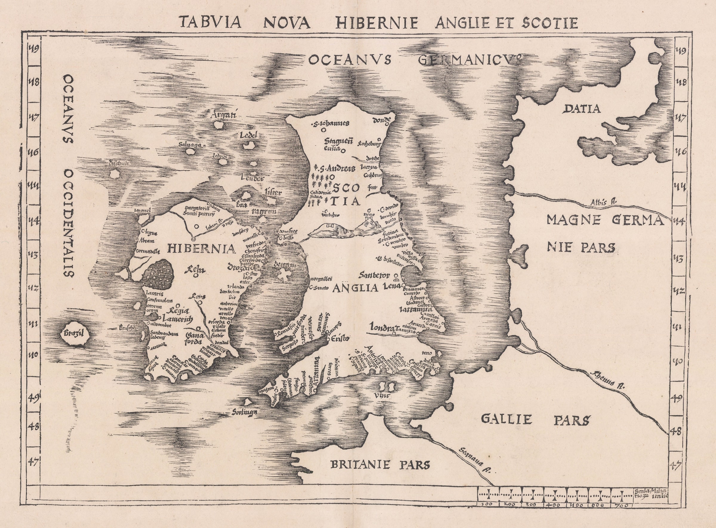
Tabula Nova Hibernie Anglie et Scotie
The first printed "modern" map of Great Britain not based on Ptolemaic geography. Issued in Waldseemuller's landmark 1513 edition of the "Geographia" or book of maps.
Martin Waldeseemuller’s 1513 map of the British Isles is the first printed map of the country which does not rely on Ptolemaic geography, leading it to be called the “first modern map of Great Britain”.
It was issued in the 1513 edition of the “Geographia” or book of maps based on Claudius Ptolemy and printed in Strasbourg. This famous edition of the work added a “Supplementum” or appendix of twenty “new or modern” maps which did not use traditional Ptolemaic geography. This addition has led it to being called the first modern atlas.
Among the twenty new maps is this map of Great Britain. Scholars have not been able to track down its specific geographical source although it does bear a strong resemblance to the islands drawn on several manuscript or “portolan” charts available in Italy. In particular, the shape of this map emulates the portolans of Pinelli and Grazioso Benincasa, both of whom were active from the mid to the late 15th century. However, it differs from many of the portolan portrayals in one major way: it does not separate Scotland and England with a narrow channel of water.
There is a remarkable amount of place names on the map, many of which are unrecognisable while others are only discernible through their locations. Thus “Eristo” on the west coast is Bristol; “Antona” is Southampton while “Dobla” is Dover. The density of names on the east coast of Ireland is very unusual although most of them are not discernible. However, their number suggests an active medieval marine trade on the Irish Sea.
Finally, a notable feature is the large island of Brazil off the west coast of Ireland, a myth that would feature on maps until the end of the 16th century.
Waldseemuller’s maps are difficult to find and, as the first to show a new geographical configuration in the Supplementum, are essential pieces for any collection of maps.
[GB2044]
Share
- Tumblr
1
of
190
Join our mailing list
* denotes required fields
We will process the personal data you have supplied to communicate with you in accordance with our Privacy Policy. You can unsubscribe or change your preferences at any time by clicking the link in our emails.
Contact
The Map House
54 Beauchamp Place,
London SW3 1NY,
United Kingdom
maps@themaphouse.com
+44 (0)20 7589 4325
![]()
Copyright © 2025 The Map House
This website uses cookies
This site uses cookies to help make it more useful to you. Please contact us to find out more about our Cookie Policy.