John Thomson
51 x 63 cm
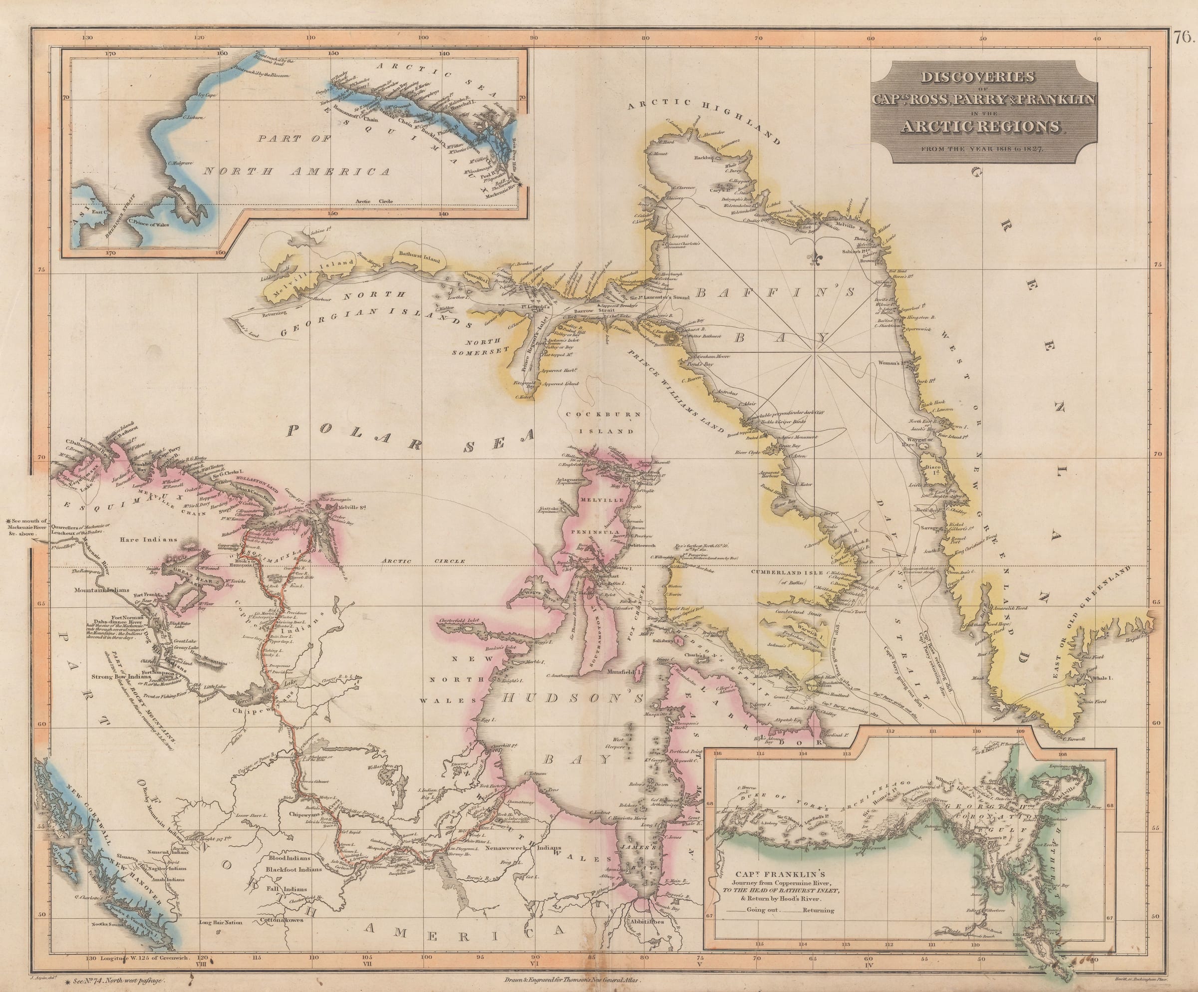
Discoveries of Capt.s Ross, Parry & Franklin in the Arctic Regions from the Year 1818 to 1827.
Fascinating uncommon map of the Canadian Arctic with remarkable contemporary discoveries by Captains Foxe, Ross, Parry, Franklin and Beechey, and prior to the first successful navigation of the Northwest Passage by Captain McClure in 1854.
Geographically, the map extends from the mouth of the
Mackenzie River and modern-day Inuvialuit Lands in the northwest and the
Pacific Coast from Admiralty Island and Vancouver Island (omitting Alaska),
extending east to show Baffin Bay and Greenland.
Across the map are annotated routes for several landmark British
Arctic explorations, with labelled solid and dotted lines indicating voyages
and most of which originate from the Davis Strait between Labrador and
Greenland (as starting in England).
John Ross (1777-1856) was a
Scottish naval officer who was employed by the British Admiralty to find the
suspected Northwest Passage in 1818 aboard the vessel, the “Isabella”. While
the expedition was not successful in navigating or even finding the passage, they
made important scientific discoveries on currents, tides, the ice limits and magnetism
in the North, and also collected specimens along the way. Ross would next
venture to the Canadian Arctic in 1829 (until 1833) to discover and survey the
Boothia Peninsula and Gulf, and King William Island.
Accompanying Ross on the First Arctic Expedition was Sir
William Edward Parry (1790-1855), English explorer and the commanding officer
of the “Alexander” which first navigated the coastline of Baffin Bay, but sadly
did not make any new discoveries. In 1819 however, Parry was given command of a
new ship, the HMS Hecla and found a passage though the Lancaster Sound. This
gave him a taste to return to the Arctic a few years later in search of the legendary
Northwest Passage.
His second voyage set sail from England in the April of 1821.
Again, aboard the Hecla, and accompanied by the Fury, they sailed through the
Hudson Strait, through to Foxe Basin and followed the coastline of the Melville
Peninsula. By October, the expedition was frozen in and they settled at the
aptly named “Winter Island” for 9 months. Once the ice had eased off, they
headed further north to the Hecla and Fury Strait (just south of Cockburn
Island) but were forced to return home due to lack of provisions.
Parry would make his third and final attempt to find the
Northwest Passage in 1824, looking to make headway by passing through the
Prince Regent Inlet. The ice conditions disrupted the expedition, and they were
forced to stay put and winter at the Inlet. Irreparable damage and subsequent
loss of the HMS Fury caused by the ice meant that both crews had board the Hecla
and share resources and owing to the strain this put on the expedition, they
were forced to return to England.
Captain Sir James Clark Ross (1800-1862), famed polar
explorer and the nephew of John Ross, participated in the First Arctic
Expedition led by his uncle aboard the Isabella. And from 1819 to 1827
joined Parry on four separate expeditions to the Arctic.
On the map his first outbound
voyage is dated 1819 (returning 1820) and the second 1821 (returning 1822). He
took great interest in the scientific measurements and natural history
specimens that were being collected. Shortly after this map was published,
James Clark Ross first discovered the North Magnetic Pole, while he was serving
on the second Arctic Expedition of his uncle, John Ross. He found it on 1st
June 1831 at Cape Adelaide on the Boothia Peninsula.
Also featured on the map are the voyages of Sir John Franklin
(1786-1847), seasoned British Naval officer and Arctic Explorer. This map shows
both of Franklin’s expeditions through the Canadian Arctic; The Coppermine Expedition,
from 1819 to 1822, to chart the north coast of Canada from the mouth of the
Coppermine River. And the Mackenzie River Expedition from 1825 to 1827 where
the aim was to explore the area between the mouths of the Mackenzie, Coppermine
Rivers and the Bering Strait (modern day Nunavut, Northwest Territories, Yukon
and Alaska). The result was the mapping of more that 620 miles of previously
unknown coastline. One of Franklin's routes has been highlighted in red/orange.
It would be Franklin’s ill-fated 1945 Northwest Passage
Expedition that would be his last, but in the search for Franklin and his men, it
would lead Captain Sir Robert McClure (1807-1873) aboard the HMS
Investigator to discover the route from the Pacific to the Atlantic through
the Arctic.
There are two insets on the map. The first inset in the upper
left is an eastward extension to show the mouth of the Mackenzie River east to
the North American coast and the Bering Strait. The second inset map shows Franklin's route from
the Coppermine River to Bathurst Inlet (line), and subsequent return via Hood's
River (dotted line).
First Nations settlements are marked in bold text across the
map. Other notable annotations include “Fox’s farthest north 21st
Sept. 1632”, and “Pt. Peregrine, the northernmost land sighted by Fox”,
referring to 16th century English explorer Luke Foxe (1586-c.1635)
who was searching for the Northwest Passage. This is noted due northeast of Southampton
Islands and the Channel that bears his name.
In the upper left inset map, in
the northernmost point shown on the Pacific northwest coastline another two
annotations read “Point reach’d by the Blossom” and “Point reach’d by
the Blossom’s boat”. This is in reference to the HMS Blossom under the
command of Captain Frederick William Beechy during the 1825–1828 expedition to
explore the Bering Strait from the east ‘in concert with Franklin and Parry’. Beechey
had previously accompanied both Franklin in 1818 aboard the HMS Trent, and
Parry in 1919 aboard HMS Hecla. He then
set sail in the Mediterranean on the HMS Adventure only to return to the Arctic
in 1825.
This rare map would have been published within an 1830
edition of Thomson's successful “New General Atlas”. Earlier editions (Wyld, circa
1829) do not appear to include the inset maps, but instead feature illustrative
vignettes of the coastlines.
Original hand colour. [POLAR553]
Join our mailing list
* denotes required fields
We will process the personal data you have supplied to communicate with you in accordance with our Privacy Policy. You can unsubscribe or change your preferences at any time by clicking the link in our emails.
![]()
Join our mailing list
* denotes required fields
We will process the personal data you have supplied to communicate with you in accordance with our Privacy Policy. You can unsubscribe or change your preferences at any time by clicking the link in our emails.