- All
- AFRICA
- ▪ Central Africa
- ▪ East Africa
- ▪ North Africa
- ▪ Southern Africa
- ▪ West Africa
- ▪ Atlantic Islands
- AMERICAS
-
▪ United States (USA)
- USA - East
- USA - Midwest
- USA - Northeast
- USA - Southeast
- USA - West & Southwest
- Alabama
- Alaska
- Arizona
- Arkansas
- California
- Colorado
- Connecticut
- Delaware
- Florida
- Georgia
- Hawaii
- Idaho
- Illinois
- Indiana
- Iowa
- Kansas
- Kentucky
- Louisiana
- Maine
- Maryland
- Massachusetts
- Michigan
- Minnesota
- Mississippi
- Missouri
- Montana
- Nebraska
- Nevada
- New Hampshire
- New Jersey
- New Mexico
- New York
- New York City
- North Carolina
- North Dakota
- Ohio
- Oklahoma
- Oregon
- Pennsylvania
- Rhode Island
- South Carolina
- South Dakota
- Tennessee
- Texas
- Utah
- Vermont
- Virginia
- Washington
- Washington, D.C.
- West Virginia
- Wisconsin
- Wyoming
- ▪ North America
- ▪ South America
- ▪ Caribbean
- ASIA
- ▪ East Asia
- ▪ Southeast Asia
- ▪ India & South Asia
- ▪ Middle East & Turkey
- BRITISH ISLES
- ▪ London
-
▪ England
- English Cities
- Bedfordshire
- Berkshire
- Buckinghamshire
- Cambridgeshire
- Cheshire
- Cornwall
- Cumbria
- Derbyshire
- Devon
- Dorset
- Durham
- Essex
- Gloucestershire
- Hampshire
- Herefordshire
- Hertfordshire
- Huntingdonshire
- Isle of Wight
- Kent
- Lancashire
- Leicestershire
- Lincolnshire
- Middlesex
- Norfolk
- Northamptonshire
- Northumberland
- Nottinghamshire
- Oxfordshire
- Rutland
- Shropshire
- Somerset
- Staffordshire
- Suffolk
- Surrey
- Sussex
- Warwickshire
- Wiltshire
- Worcestershire
- Yorkshire
- Yorkshire East Riding
- Yorkshire North Riding
- Yorkshire West Riding
- ▪ Ireland
- ▪ Scotland
- ▪ Wales
- EUROPE
- ▪ Austria & Switzerland
- ▪ Benelux Region
- ▪ Central & Eastern Europe
- ▪ France & Monaco
- ▪ Germany
- ▪ Greece
- ▪ Italy
- ▪ Mediterranean Sea
- ▪ Spain & Portugal
- ▪ Scandinavia & Baltics
- ▪ Russia, Ukraine & Caucasus
- OCEANIA
- ▪ Australia
- ▪ New Zealand
- ▪ Pacific Ocean & Islands
- ▪ Papua New Guinea
- POLAR
- CELESTIAL
- WORLD
- GLOBES & INSTRUMENTS
- THEMATIC
- COLLABORATIONS
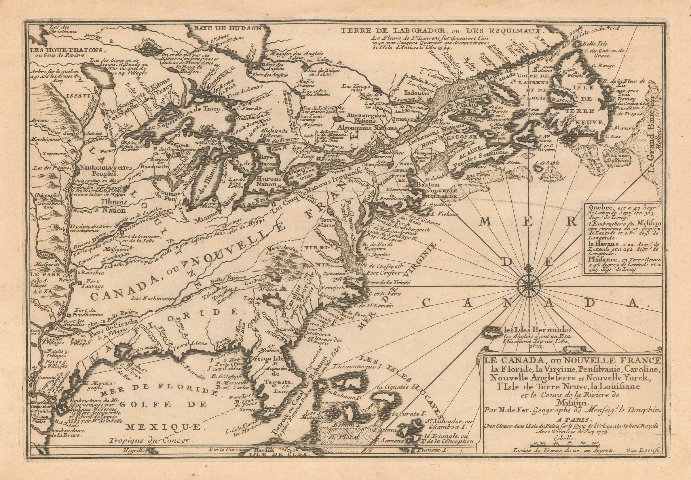
Nicolas de Fer
25 x 35 cm
De Fer’s fascinating map of eastern North America from Newfoundland to the Mississippi east to west and Hudson’s Bay to the Gulf of Mexico north to south.
Badly out of date for its geography even at the time of printing, the main function of this map is political as opposed to geographical. One of its main errors is the siting of the mouth of the Mississippi River approximately three hundred miles west of its correct location. Initially this was due to an incorrect bearing communicated by Sieur La Salle during his exploration; it appeared briefly on late 17th century maps of the region, most notably on the map of North America by Coronelli. By 1702, the first edition of this map, this error had been corrected for several years. Yet de Fer, despite his access to the latest French cartographic documents, chooses to use this incorrect location. Politically, it enables him to stake French claims in North America deep into the western region which belonged to Spain by claiming these areas were east of the Mississippi. Numerous French forts are sited along the eastern bank of the river, including Fort du Prudhomme and Fort Sauvage, strengthening these claims.
In the east, the English colonies have been confined to a narrow strip of coastline and finish at the southern border of Virginia. Carolina and much of modern Georgia has been labelled as “French Florida” a claim to the region dating back to 1565 and ignored by the English who had settled the region in the mid-17th century.
Within this narrow eastern strip and the Mississippi River flowing several hundred miles west of where it should be, lies an enormous “Canada ou Nouvelle France” aided by “La Louisiane” named roughly within the eastern drainage basin of the Mississippi.
In Canada, the British are grudgingly shown with several forts and outposts along the shore of Hudson’s Bay but a note under Terre Laborador states that the St. Lawrence River was explored by the French Jacques Cartier as far back as 1534.
Maps such as these would enrage the British establishment and a cartographic war would ensue shortly with the British producing maps showing their eastern colonies stretching as far west as the Mississippi and theoretically beyond.
This example of the map is the second state of 1705 and is one of the earliest examples of this cartographic war. [USA9804]
- X
- Tumblr
Join our mailing list
* denotes required fields
We will process the personal data you have supplied to communicate with you in accordance with our Privacy Policy. You can unsubscribe or change your preferences at any time by clicking the link in our emails.
Contact
The Map House
54 Beauchamp Place,
London SW3 1NY,
United Kingdom
maps@themaphouse.com
+44 (0)20 7589 4325
![]()
This website uses cookies
This site uses cookies to help make it more useful to you. Please contact us to find out more about our Cookie Policy.
Join our mailing list
* denotes required fields
We will process the personal data you have supplied to communicate with you in accordance with our Privacy Policy. You can unsubscribe or change your preferences at any time by clicking the link in our emails.