- All
- AFRICA
- ▪ Central Africa
- ▪ East Africa
- ▪ North Africa
- ▪ Southern Africa
- ▪ West Africa
- ▪ Atlantic Islands
- AMERICAS
-
▪ United States (USA)
- USA - East
- USA - Midwest
- USA - Northeast
- USA - Southeast
- USA - West & Southwest
- Alabama
- Alaska
- Arizona
- Arkansas
- California
- Colorado
- Connecticut
- Delaware
- Florida
- Georgia
- Hawaii
- Idaho
- Illinois
- Indiana
- Iowa
- Kansas
- Kentucky
- Louisiana
- Maine
- Maryland
- Massachusetts
- Michigan
- Minnesota
- Mississippi
- Missouri
- Montana
- Nebraska
- Nevada
- New Hampshire
- New Jersey
- New Mexico
- New York
- New York City
- North Carolina
- North Dakota
- Ohio
- Oklahoma
- Oregon
- Pennsylvania
- Rhode Island
- South Carolina
- South Dakota
- Tennessee
- Texas
- Utah
- Vermont
- Virginia
- Washington
- Washington, D.C.
- West Virginia
- Wisconsin
- Wyoming
- ▪ North America
- ▪ South America
- ▪ Caribbean
- ASIA
- ▪ East Asia
- ▪ Southeast Asia
- ▪ India & South Asia
- ▪ Middle East & Turkey
- BRITISH ISLES
- ▪ London
-
▪ England
- English Cities
- Bedfordshire
- Berkshire
- Buckinghamshire
- Cambridgeshire
- Cheshire
- Cornwall
- Cumbria
- Derbyshire
- Devon
- Dorset
- Durham
- Essex
- Gloucestershire
- Hampshire
- Herefordshire
- Hertfordshire
- Huntingdonshire
- Isle of Wight
- Kent
- Lancashire
- Leicestershire
- Lincolnshire
- Middlesex
- Norfolk
- Northamptonshire
- Northumberland
- Nottinghamshire
- Oxfordshire
- Rutland
- Shropshire
- Somerset
- Staffordshire
- Suffolk
- Surrey
- Sussex
- Warwickshire
- Wiltshire
- Worcestershire
- Yorkshire
- Yorkshire East Riding
- Yorkshire North Riding
- Yorkshire West Riding
- ▪ Ireland
- ▪ Scotland
- ▪ Wales
- EUROPE
- ▪ Austria & Switzerland
- ▪ Benelux Region
- ▪ Central & Eastern Europe
- ▪ France & Monaco
- ▪ Germany
- ▪ Greece
- ▪ Italy
- ▪ Mediterranean Sea
- ▪ Spain & Portugal
- ▪ Scandinavia & Baltics
- ▪ Russia, Ukraine & Caucasus
- OCEANIA
- ▪ Australia
- ▪ New Zealand
- ▪ Pacific Ocean & Islands
- ▪ Papua New Guinea
- POLAR
- CELESTIAL
- WORLD
- GLOBES & INSTRUMENTS
- THEMATIC
- COLLABORATIONS
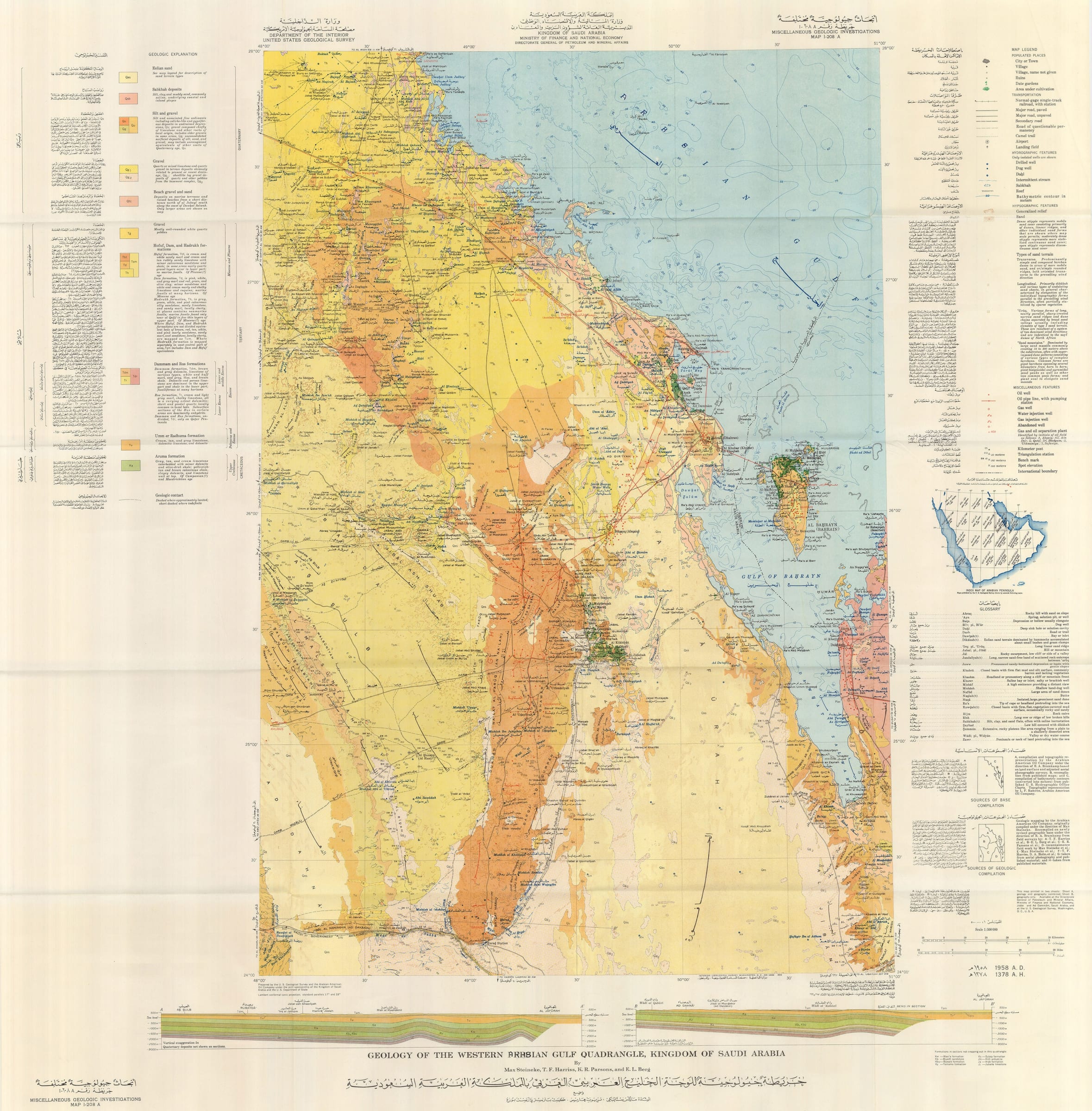
Kingdom of Saudi Arabia / USGS
106 x 104 cm
This is one sheet of a series of twenty-one bilingual and dual-dated maps which were issued as a joint venture between the government of Saudi Arabia and the United States Geological Survey. This survey was the first to produce a full series of geological and geographical maps of the Kingdom of Saudi Arabia and was instrumental in its establishment as a major global force in the production of natural resources.
The overseer of the project was a veteran American geologist, Glen F. Brown, who had already been to the Kingdom in the mid-1940s and had formed a very good relationship with the Saudi government. They asked for his further co-operation in 1950 and the result was the formation of a team consisting of Brown, geologists appointed by the Saudi Ministry of Finance and National Economy, as well as geologists from Aramco, who had been active in the Kingdom for decades.
The survey used the latest techniques available including aerial photography and was conducted from 1950-58. This project was considered highly important by King Abdulaziz Ibn Saud and its aims encompassed all aspects of cartography; it was to enable not only the search for natural resources but also aid in advances for agriculture, civil and military engineering and general infrastructure projects. The results were seminal for the mapping of the region and to this day, this survey forms the basis of any modern maps of the Kingdom.
This particular sheet covers the Western shore of the Arabian Gulf together with the island of Bahrain and the Western shore of Qatar. It is a highly significant map for the discovery, record and production of natural resources in the Peninsula and Bahrain. It lists four authors, all of whom were working for Aramco and who read like a Who's Who of important geologists in the annals of oil discovery and production.
Max Steinike is the man credited with the discovery of the first commercially viable oil field in Saudi Arabia, namely the Dammam Field; E.L. Berg, while working with Steinike, is credited with creating the "discovery map" of the Ghawar Field, the "elephant in the desert", still acknowledged as the largest oil field in the world. T.F. Harriss and K.R. Parsons were also part of the pioneering team of Aramco geologists of the 40s, 50s and 60s.
Reflecting the decades of work performed by Aramco and incorporating the company's existing surveys, the map is extraordinarily detailed. It shows both geological and topographical features with painstaking accuracy, all of which are carefully and bilingually keyed on the side panels.
However, it is the presence of the oil fields and wells that make this map so extraordinary. These features are specifically marked in red and show the location of all the legendary fields such as Dammam, Abuqaiq and of course, Ghawar with its five super wells: Ain Dar, Shegdum, Uthmaniya, Haradh and Huiya. The map also locates oil wells on Bahrain, and Dukhan, the largest oil field in Qatar. Together with the fields, it also marks the supporting infrastructure such as pipelines with pumping stations, water injections wells and gas injection wells. Again, all of these symbols are painstakingly keyed bilingually in the right margin.
Finally, both the sleeve and the map show a series of manuscript amendments between the word "Persian" and "Arabian" when referring to the Gulf, illustrating the assertion of a separate Arabian identity and a realisation of its importance within the Middle East and on the world stage.
It is impossible to overemphasize the importance of this survey to the development of Saudi Arabia.
[MEAST3997]
- X
- Tumblr
Join our mailing list
* denotes required fields
We will process the personal data you have supplied to communicate with you in accordance with our Privacy Policy. You can unsubscribe or change your preferences at any time by clicking the link in our emails.
Contact
The Map House
54 Beauchamp Place,
London SW3 1NY,
United Kingdom
maps@themaphouse.com
+44 (0)20 7589 4325
![]()
This website uses cookies
This site uses cookies to help make it more useful to you. Please contact us to find out more about our Cookie Policy.
Join our mailing list
* denotes required fields
We will process the personal data you have supplied to communicate with you in accordance with our Privacy Policy. You can unsubscribe or change your preferences at any time by clicking the link in our emails.