- All
- AFRICA
- ▪ Central Africa
- ▪ East Africa
- ▪ North Africa
- ▪ Southern Africa
- ▪ West Africa
- ▪ Atlantic Islands
- AMERICAS
-
▪ United States (USA)
- USA - East
- USA - Midwest
- USA - Northeast
- USA - Southeast
- USA - West & Southwest
- Alabama
- Alaska
- Arizona
- Arkansas
- California
- Colorado
- Connecticut
- Delaware
- Florida
- Georgia
- Hawaii
- Idaho
- Illinois
- Indiana
- Iowa
- Kansas
- Kentucky
- Louisiana
- Maine
- Maryland
- Massachusetts
- Michigan
- Minnesota
- Mississippi
- Missouri
- Montana
- Nebraska
- Nevada
- New Hampshire
- New Jersey
- New Mexico
- New York
- New York City
- North Carolina
- North Dakota
- Ohio
- Oklahoma
- Oregon
- Pennsylvania
- Rhode Island
- South Carolina
- South Dakota
- Tennessee
- Texas
- Utah
- Vermont
- Virginia
- Washington
- Washington, D.C.
- West Virginia
- Wisconsin
- Wyoming
- ▪ North America
- ▪ South America
- ▪ Caribbean
- ASIA
- ▪ East Asia
- ▪ Southeast Asia
- ▪ India & South Asia
- ▪ Middle East & Turkey
- BRITISH ISLES
- ▪ London
-
▪ England
- English Cities
- Bedfordshire
- Berkshire
- Buckinghamshire
- Cambridgeshire
- Cheshire
- Cornwall
- Cumbria
- Derbyshire
- Devon
- Dorset
- Durham
- Essex
- Gloucestershire
- Hampshire
- Herefordshire
- Hertfordshire
- Huntingdonshire
- Isle of Wight
- Kent
- Lancashire
- Leicestershire
- Lincolnshire
- Middlesex
- Norfolk
- Northamptonshire
- Northumberland
- Nottinghamshire
- Oxfordshire
- Rutland
- Shropshire
- Somerset
- Staffordshire
- Suffolk
- Surrey
- Sussex
- Warwickshire
- Wiltshire
- Worcestershire
- Yorkshire
- Yorkshire East Riding
- Yorkshire North Riding
- Yorkshire West Riding
- ▪ Ireland
- ▪ Scotland
- ▪ Wales
- EUROPE
- ▪ Austria & Switzerland
- ▪ Benelux Region
- ▪ Central & Eastern Europe
- ▪ France & Monaco
- ▪ Germany
- ▪ Greece
- ▪ Italy
- ▪ Mediterranean Sea
- ▪ Spain & Portugal
- ▪ Scandinavia & Baltics
- ▪ Russia, Ukraine & Caucasus
- OCEANIA
- ▪ Australia
- ▪ New Zealand
- ▪ Pacific Ocean & Islands
- ▪ Papua New Guinea
- POLAR
- CELESTIAL
- WORLD
- GLOBES & INSTRUMENTS
- THEMATIC
- COLLABORATIONS
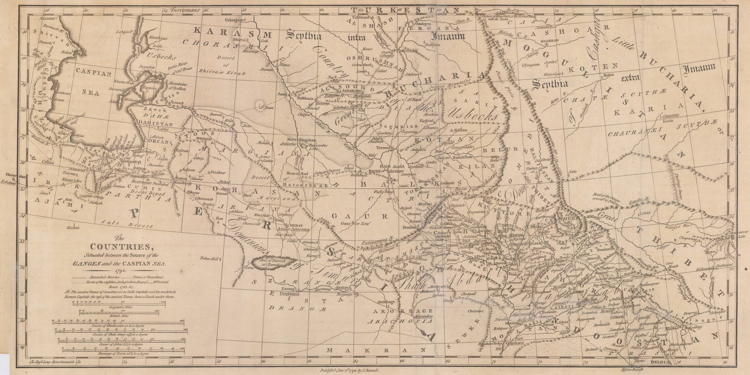
James Rennell
26 x 51 cm
James Rennell became the first Surveyor General of Bengal and thus had unfettered access to the latest manuscript charts of the northern regions of India, modern Pakistan and Afghanistan.
He retired from the East India Company in 1777 and spent the rest of his life in geographical and historical research, chiefly in the archives in East India House in London.
This map reflects that research, combining extraordinary detail of many highly inaccessible regions together with historical events such as the routes of Alexander the Great and the route and conquests of Tamerlane the founder of the Timurid Empire. Indeed, all of the areas on this map would have been part of the Timurid Empire in the early 15th century.
As a footnote, Rennell also references the extraordinary journey of Ruy Gonzalez de Clavijo, ambassador of Henry III of Castile to the court of Tamerlane in Samarkand. The maps shows the route of the embassy in 1404-5.
[IC2857]
- X
- Tumblr
Join our mailing list
* denotes required fields
We will process the personal data you have supplied to communicate with you in accordance with our Privacy Policy. You can unsubscribe or change your preferences at any time by clicking the link in our emails.
Contact
The Map House
54 Beauchamp Place,
London SW3 1NY,
United Kingdom
maps@themaphouse.com
+44 (0)20 7589 4325
![]()
This website uses cookies
This site uses cookies to help make it more useful to you. Please contact us to find out more about our Cookie Policy.
Join our mailing list
* denotes required fields
We will process the personal data you have supplied to communicate with you in accordance with our Privacy Policy. You can unsubscribe or change your preferences at any time by clicking the link in our emails.