- All
- AFRICA
- ▪ Central Africa
- ▪ East Africa
- ▪ North Africa
- ▪ Southern Africa
- ▪ West Africa
- ▪ Atlantic Islands
- AMERICAS
-
▪ United States (USA)
- USA - East
- USA - Midwest
- USA - Northeast
- USA - Southeast
- USA - West & Southwest
- Alabama
- Alaska
- Arizona
- Arkansas
- California
- Colorado
- Connecticut
- Delaware
- Florida
- Georgia
- Hawaii
- Idaho
- Illinois
- Indiana
- Iowa
- Kansas
- Kentucky
- Louisiana
- Maine
- Maryland
- Massachusetts
- Michigan
- Minnesota
- Mississippi
- Missouri
- Montana
- Nebraska
- Nevada
- New Hampshire
- New Jersey
- New Mexico
- New York
- New York City
- North Carolina
- North Dakota
- Ohio
- Oklahoma
- Oregon
- Pennsylvania
- Rhode Island
- South Carolina
- South Dakota
- Tennessee
- Texas
- Utah
- Vermont
- Virginia
- Washington
- Washington, D.C.
- West Virginia
- Wisconsin
- Wyoming
- ▪ North America
- ▪ South America
- ▪ Caribbean
- ASIA
- ▪ East Asia
- ▪ Southeast Asia
- ▪ India & South Asia
- ▪ Middle East & Turkey
- BRITISH ISLES
- ▪ London
-
▪ England
- English Cities
- Bedfordshire
- Berkshire
- Buckinghamshire
- Cambridgeshire
- Cheshire
- Cornwall
- Cumbria
- Derbyshire
- Devon
- Dorset
- Durham
- Essex
- Gloucestershire
- Hampshire
- Herefordshire
- Hertfordshire
- Huntingdonshire
- Isle of Wight
- Kent
- Lancashire
- Leicestershire
- Lincolnshire
- Middlesex
- Norfolk
- Northamptonshire
- Northumberland
- Nottinghamshire
- Oxfordshire
- Rutland
- Shropshire
- Somerset
- Staffordshire
- Suffolk
- Surrey
- Sussex
- Warwickshire
- Wiltshire
- Worcestershire
- Yorkshire
- Yorkshire East Riding
- Yorkshire North Riding
- Yorkshire West Riding
- ▪ Ireland
- ▪ Scotland
- ▪ Wales
- EUROPE
- ▪ Austria & Switzerland
- ▪ Benelux Region
- ▪ Central & Eastern Europe
- ▪ France & Monaco
- ▪ Germany
- ▪ Greece
- ▪ Italy
- ▪ Mediterranean Sea
- ▪ Spain & Portugal
- ▪ Scandinavia & Baltics
- ▪ Russia, Ukraine & Caucasus
- OCEANIA
- ▪ Australia
- ▪ New Zealand
- ▪ Pacific Ocean & Islands
- ▪ Papua New Guinea
- POLAR
- CELESTIAL
- WORLD
- GLOBES & INSTRUMENTS
- THEMATIC
- COLLABORATIONS
Service géographique de l'Indochine
Cambodia, Laos and Vietnam (French Indochina), 1954
35 ½ x 24 in
90 x 61 cm
90 x 61 cm
SEAS5091
£ 650.00
Service géographique de l'Indochine, Cambodia, Laos and Vietnam (French Indochina), 1954
Sold
%3Cdiv%20class%3D%22artist%22%3EService%20g%C3%A9ographique%20de%20l%27Indochine%3C/div%3E%3Cdiv%20class%3D%22title_and_year%22%3E%3Cspan%20class%3D%22title_and_year_title%22%3ECambodia%2C%20Laos%20and%20Vietnam%20%28French%20Indochina%29%3C/span%3E%2C%20%3Cspan%20class%3D%22title_and_year_year%22%3E1954%3C/span%3E%3C/div%3E%3Cdiv%20class%3D%22dimensions%22%3E35%20%C2%BD%20x%2024%20in%3Cbr/%3E%0A90%20x%2061%20cm%3C/div%3E
Cambodge - Laos - Viet Nam, croquis Physique et Routier Striking large-format map of French Indo-China, covering modern day Cambodia, Laos and Vietnam, with part of Thailand and China....
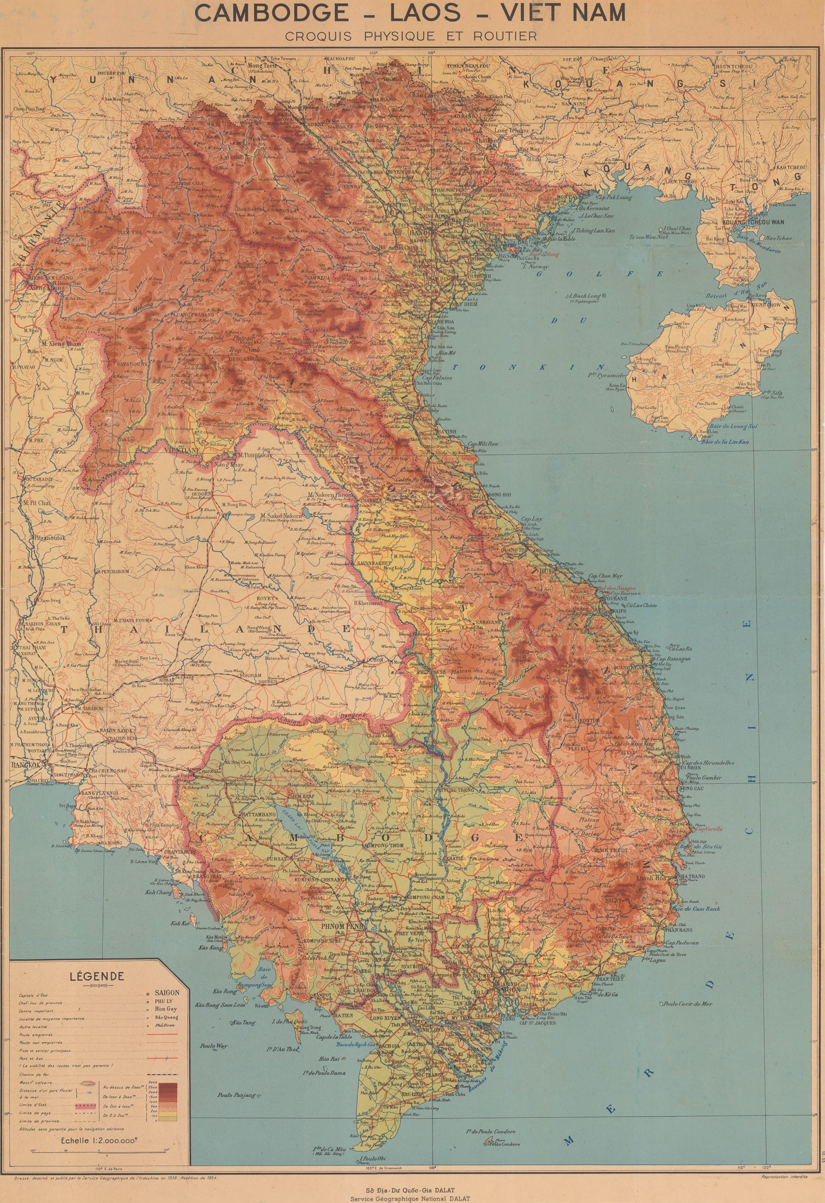
Cambodge - Laos - Viet Nam, croquis Physique et Routier
Striking large-format map of French Indo-China, covering modern day Cambodia, Laos and Vietnam, with part of Thailand and China. The map is incredibly detailed and focuses on the physical geography of the countries, and their road and railway networks. A comprehensive legend to the symbols and markings features in the lower left corner of the map.
This map was published during the turbulent final year of the First Indochina War (1946-1954), which resulted in a French defeat at Điện Biên Phủ by the Việt Minh. Shortly after, the French withdrew and lost their Indochinese colonies.
The cartography for the map was compiled by Sở Địa-Dư Quốc-Gia [Department of Geography-National Geography] based in Đà Lạt, Vietnam and published by Service Géographique de l'Indochine. Earlier iterations of this map are noted to have been first printed in 1938, and this example includes corrections to 1954.
Service Géographique de l'Indochine was established in 1899 by the French forces occupying the region, with the intention of creating the most up-to-date maps using modern scientific mapping practices to map their colony. There is not a formal date for when Service Géographique ceased to published but it is likely that this occurred when the French left Vietnam around May 1954.
A note in the lower right margin states that it is not for reproduction ('Reproduction interdite') which would suggest that it was not for public consumption, or commercially available.
Printed colour. (SL) [SEAS5091]
Share
- Tumblr
Join our mailing list
* denotes required fields
We will process the personal data you have supplied to communicate with you in accordance with our Privacy Policy. You can unsubscribe or change your preferences at any time by clicking the link in our emails.
Contact
The Map House
54 Beauchamp Place,
London SW3 1NY,
United Kingdom
maps@themaphouse.com
+44 (0)20 7589 4325
![]()
Copyright © 2025 The Map House
This website uses cookies
This site uses cookies to help make it more useful to you. Please contact us to find out more about our Cookie Policy.