- All
- AFRICA
- ▪ Central Africa
- ▪ East Africa
- ▪ North Africa
- ▪ Southern Africa
- ▪ West Africa
- ▪ Atlantic Islands
- AMERICAS
-
▪ United States (USA)
- USA - East
- USA - Midwest
- USA - Northeast
- USA - Southeast
- USA - West & Southwest
- Alabama
- Alaska
- Arizona
- Arkansas
- California
- Colorado
- Connecticut
- Delaware
- Florida
- Georgia
- Hawaii
- Idaho
- Illinois
- Indiana
- Iowa
- Kansas
- Kentucky
- Louisiana
- Maine
- Maryland
- Massachusetts
- Michigan
- Minnesota
- Mississippi
- Missouri
- Montana
- Nebraska
- Nevada
- New Hampshire
- New Jersey
- New Mexico
- New York
- New York City
- North Carolina
- North Dakota
- Ohio
- Oklahoma
- Oregon
- Pennsylvania
- Rhode Island
- South Carolina
- South Dakota
- Tennessee
- Texas
- Utah
- Vermont
- Virginia
- Washington
- Washington, D.C.
- West Virginia
- Wisconsin
- Wyoming
- ▪ North America
- ▪ South America
- ▪ Caribbean
- ASIA
- ▪ East Asia
- ▪ Southeast Asia
- ▪ India & South Asia
- ▪ Middle East & Turkey
- BRITISH ISLES
- ▪ London
-
▪ England
- English Cities
- Bedfordshire
- Berkshire
- Buckinghamshire
- Cambridgeshire
- Cheshire
- Cornwall
- Cumbria
- Derbyshire
- Devon
- Dorset
- Durham
- Essex
- Gloucestershire
- Hampshire
- Herefordshire
- Hertfordshire
- Huntingdonshire
- Isle of Wight
- Kent
- Lancashire
- Leicestershire
- Lincolnshire
- Middlesex
- Norfolk
- Northamptonshire
- Northumberland
- Nottinghamshire
- Oxfordshire
- Rutland
- Shropshire
- Somerset
- Staffordshire
- Suffolk
- Surrey
- Sussex
- Warwickshire
- Wiltshire
- Worcestershire
- Yorkshire
- Yorkshire East Riding
- Yorkshire North Riding
- Yorkshire West Riding
- ▪ Ireland
- ▪ Scotland
- ▪ Wales
- EUROPE
- ▪ Austria & Switzerland
- ▪ Benelux Region
- ▪ Central & Eastern Europe
- ▪ France & Monaco
- ▪ Germany
- ▪ Greece
- ▪ Italy
- ▪ Mediterranean Sea
- ▪ Spain & Portugal
- ▪ Scandinavia & Baltics
- ▪ Russia, Ukraine & Caucasus
- OCEANIA
- ▪ Australia
- ▪ New Zealand
- ▪ Pacific Ocean & Islands
- ▪ Papua New Guinea
- POLAR
- CELESTIAL
- WORLD
- GLOBES & INSTRUMENTS
- THEMATIC
- COLLABORATIONS
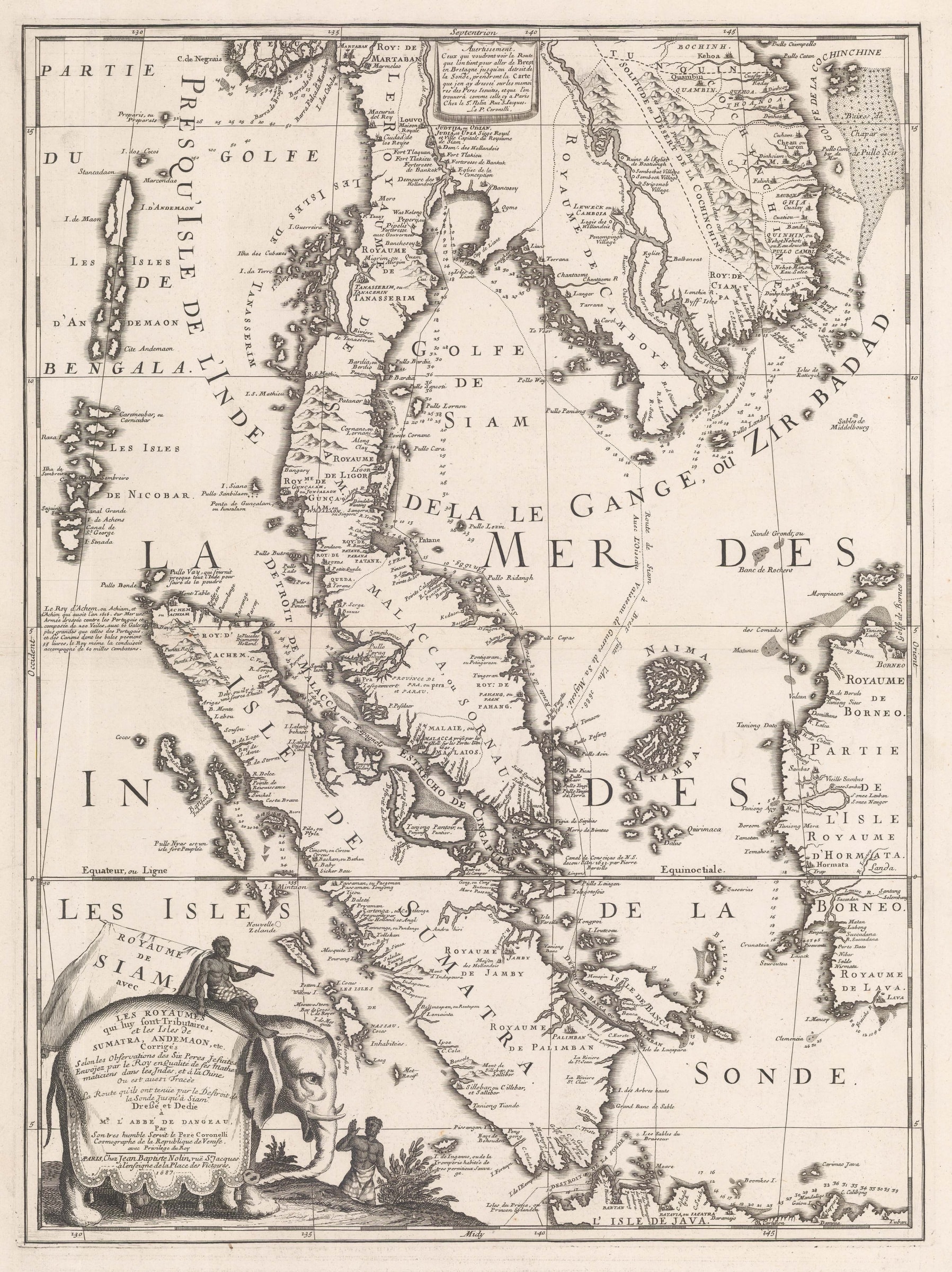
Vincenzo Coronelli
61 x 45 cm
This extraordinary map of the Kingdom of Siam actually covers modern Malaysia, Singapore, Thailand, the Indonesian island of Sumatra, as well as the coasts of Cambodia, part of Vietnam and western Borneo.
The cartouche on the lower left states that the information for the map was taken from the accounts of "six Jesuit Fathers". This is a reference to the famous French Embassy to the court of the King of Siam led by Alexandre, Chevalier de Chaumont in 1685, which was sponsored by Louis XIV and facilitated by the Society of Jesus. The Embassy had several aims: it was to escort two Siamese ambassadors back to their country after they had arrived at the French court in 1684. Alexandre was to attempt to convert King Narai of Siam to Catholicism and to gain preferential commercial terms for French merchants over their Dutch and Portuguese rivals and finally to escort a mission of six Jesuit Fathers under Superior Jean de Fontaney as far as Siam on their way to China. The mission set out from Brest in 1685 and returned in 1686 with most of its political aims unsuccessful. Although the Jesuits did go on to China and the Siamese ambassadors arrived safely back in their country, King Narai was not converted to Catholicism and French merchants did not gain the preferential conditions they had hoped for. Indeed, exactly the opposite happened. Powerful local factions became extremely agitated at the prospect of further European influence in the Court and in 1688, King Narai was deposed and a far more xenophobic government was installed instead.
This map was drawn from the manuscripts which were brought back by de Chaumont and his companions. They were accessed by a young Vincenzo Maria Coronelli, a Franciscan Father from Venice who had been invited by Louis the XIV to Paris to supervise the construction of a monumental pair of globes, the so called "Marly Globes". The map was published by Jean Baptiste Nolin and, due to its first hand sources, immediately superseded earlier maps of the region, especially for the geography of the southern shore of Siam, Cambodia and the Malay Peninsula. The route of the Embassy is clearly shown as it arrives in 1685 and then leaves in 1686. Further details include the position of the Fort of Bangkok, the position of the then capital of Siam, Ayuthaya, detail on the Cho Phraya River, here called the "Rivière de Siam" and the siting of the town Louvo or Lop Buri, the summer retreat of King Narai where the French mission performed important astronomical readings during the Lunar Eclipse of 1685. The influence of the map was profound, with derivatives being published well into the 18th century, including by Nolin's son, who issued an identical example of the map in 1742, with only a date change.
Finally, a note must be made on the aesthetics of the map. The quality and clarity of the engraving is magnificent; the lower left of the map contains an elaborate of cartouche, stating the provenance of its geography on the body of an elephant, referencing the fascination of the European travellers about the domestication of these animals in Siam; the illustration on the cartouche is the reason why this is one of the maps that is often called "The Elephant Map" along with another contemporary map of the region by Pierre Duval. The upper text panel advertises another map published by Nolin, tracing the full route of Chaumont's embassy, from Brest to Siam.
For its beauty, its accuracy and influence, this is cited as one of the cornerstone maps of any collection of this region.
[SEAS5022]
- X
- Tumblr
Join our mailing list
* denotes required fields
We will process the personal data you have supplied to communicate with you in accordance with our Privacy Policy. You can unsubscribe or change your preferences at any time by clicking the link in our emails.
Contact
The Map House
54 Beauchamp Place,
London SW3 1NY,
United Kingdom
maps@themaphouse.com
+44 (0)20 7589 4325
![]()
This website uses cookies
This site uses cookies to help make it more useful to you. Please contact us to find out more about our Cookie Policy.
Join our mailing list
* denotes required fields
We will process the personal data you have supplied to communicate with you in accordance with our Privacy Policy. You can unsubscribe or change your preferences at any time by clicking the link in our emails.