- All
- AFRICA
- ▪ Central Africa
- ▪ East Africa
- ▪ North Africa
- ▪ Southern Africa
- ▪ West Africa
- ▪ Atlantic Islands
- AMERICAS
-
▪ United States (USA)
- USA - East
- USA - Midwest
- USA - Northeast
- USA - Southeast
- USA - West & Southwest
- Alabama
- Alaska
- Arizona
- Arkansas
- California
- Colorado
- Connecticut
- Delaware
- Florida
- Georgia
- Hawaii
- Idaho
- Illinois
- Indiana
- Iowa
- Kansas
- Kentucky
- Louisiana
- Maine
- Maryland
- Massachusetts
- Michigan
- Minnesota
- Mississippi
- Missouri
- Montana
- Nebraska
- Nevada
- New Hampshire
- New Jersey
- New Mexico
- New York
- New York City
- North Carolina
- North Dakota
- Ohio
- Oklahoma
- Oregon
- Pennsylvania
- Rhode Island
- South Carolina
- South Dakota
- Tennessee
- Texas
- Utah
- Vermont
- Virginia
- Washington
- Washington, D.C.
- West Virginia
- Wisconsin
- Wyoming
- ▪ North America
- ▪ South America
- ▪ Caribbean
- ASIA
- ▪ East Asia
- ▪ Southeast Asia
- ▪ India & South Asia
- ▪ Middle East & Turkey
- BRITISH ISLES
- ▪ London
-
▪ England
- English Cities
- Bedfordshire
- Berkshire
- Buckinghamshire
- Cambridgeshire
- Cheshire
- Cornwall
- Cumbria
- Derbyshire
- Devon
- Dorset
- Durham
- Essex
- Gloucestershire
- Hampshire
- Herefordshire
- Hertfordshire
- Huntingdonshire
- Isle of Wight
- Kent
- Lancashire
- Leicestershire
- Lincolnshire
- Middlesex
- Norfolk
- Northamptonshire
- Northumberland
- Nottinghamshire
- Oxfordshire
- Rutland
- Shropshire
- Somerset
- Staffordshire
- Suffolk
- Surrey
- Sussex
- Warwickshire
- Wiltshire
- Worcestershire
- Yorkshire
- Yorkshire East Riding
- Yorkshire North Riding
- Yorkshire West Riding
- ▪ Ireland
- ▪ Scotland
- ▪ Wales
- EUROPE
- ▪ Austria & Switzerland
- ▪ Benelux Region
- ▪ Central & Eastern Europe
- ▪ France & Monaco
- ▪ Germany
- ▪ Greece
- ▪ Italy
- ▪ Mediterranean Sea
- ▪ Spain & Portugal
- ▪ Scandinavia & Baltics
- ▪ Russia, Ukraine & Caucasus
- OCEANIA
- ▪ Australia
- ▪ New Zealand
- ▪ Pacific Ocean & Islands
- ▪ Papua New Guinea
- POLAR
- CELESTIAL
- WORLD
- GLOBES & INSTRUMENTS
- THEMATIC
- COLLABORATIONS
James Gardner
Cotswolds - Burford, Northleach & Bourton, 1833 c.
13 x 16 ½ in
33 x 42 cm
33 x 42 cm
GLOS454
James Gardner, Cotswolds - Burford, Northleach & Bourton, 1833 c.
Reserved
%3Cdiv%20class%3D%22artist%22%3EJames%20Gardner%3C/div%3E%3Cdiv%20class%3D%22title_and_year%22%3E%3Cspan%20class%3D%22title_and_year_title%22%3ECotswolds%20-%20Burford%2C%20Northleach%20%26%20Bourton%3C/span%3E%2C%20%3Cspan%20class%3D%22title_and_year_year%22%3E1833%20c.%3C/span%3E%3C/div%3E%3Cdiv%20class%3D%22dimensions%22%3E13%20x%2016%20%C2%BD%20in%3Cbr/%3E%0A33%20x%2042%20cm%3C/div%3E
A handsomely coloured, folding example of the first edition O.S. map of a section of the northern Cotswolds surrounding Burford, Northleach, Bourton-on-the-Water, Upper and Lower Slaughter, and Kingham. Virtually every...
A handsomely coloured, folding example of the first edition O.S. map of a section of the northern Cotswolds surrounding Burford, Northleach, Bourton-on-the-Water, Upper and Lower Slaughter, and Kingham. Virtually every building, farm, wood, estate, road, and track is marked on the map, a testament to the exceptional work of the Ordnance Survey's early surveyors.
Known as the 'Old Series', the first edition of the Ordnance Survey's One-Inch maps of England and Wales were published between 1805 and 1869. This map is the southeast quarter of Sheet 44 of the One-Inch Series (after 1833 the larger O.S. map sheets were broken down into quarters for commercial sale). The map bears the imprint of James Gardner, a London engraver and map seller who was awarded the title of sole commercial agent for the Ordnance Survey from 1823 until his retirement around 1840.
Original hand-colour. [GLOS454]
Share
- Tumblr
Related artworks
-
James Gardner, 
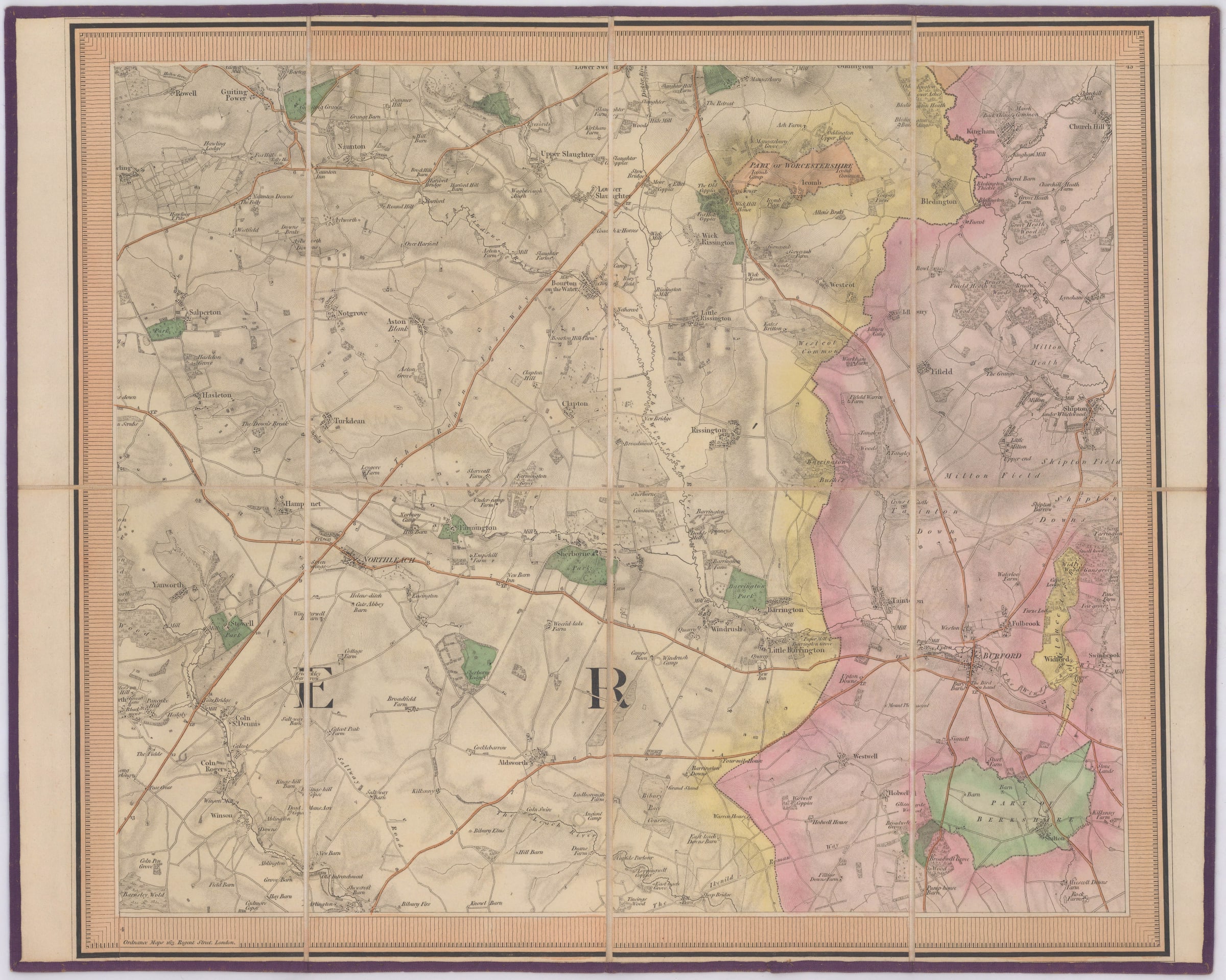
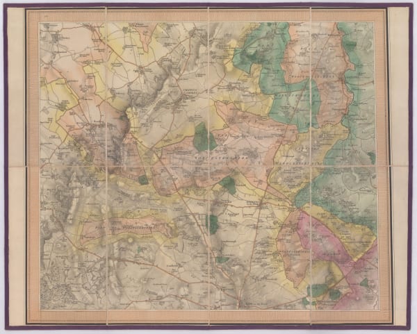
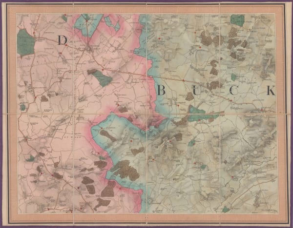
Cotswolds - Charlbury, Woodstock & Blenheim, 1833 c.Reserved
-
Cotswolds - Chipping Norton, Banbury & Deddington, 1833 c.James GardnerSeries: London%3Cdiv%20class%3D%22title_and_year%22%3E%3Cspan%20class%3D%22title_and_year_title%22%3ECotswolds%20-%20Chipping%20Norton%2C%20Banbury%20%26%20Deddington%3C/span%3E%2C%20%3Cspan%20class%3D%22title_and_year_year%22%3E1833%20c.%3C/span%3E%3C/div%3E%3Cdiv%20class%3D%22artist%22%3EJames%20Gardner%3C/div%3E%3Cdiv%20class%3D%22series%22%3E%3Cspan%20class%3D%22artwork_caption_prefix%22%3ESeries%3A%3C/span%3E%20London%3C/div%3EJames Gardner, Cotswolds - Chipping Norton, Banbury & Deddington, 1833 c.Reserved
-
Cotswolds - Moreton-in-Marsh, Chipping Campden & Stow-on-the-Wold, 1833 c.James GardnerSeries: London%3Cdiv%20class%3D%22title_and_year%22%3E%3Cspan%20class%3D%22title_and_year_title%22%3ECotswolds%20-%20Moreton-in-Marsh%2C%20Chipping%20Campden%20%26%20Stow-on-the-Wold%3C/span%3E%2C%20%3Cspan%20class%3D%22title_and_year_year%22%3E1833%20c.%3C/span%3E%3C/div%3E%3Cdiv%20class%3D%22artist%22%3EJames%20Gardner%3C/div%3E%3Cdiv%20class%3D%22series%22%3E%3Cspan%20class%3D%22artwork_caption_prefix%22%3ESeries%3A%3C/span%3E%20London%3C/div%3EJames Gardner, Cotswolds - Moreton-in-Marsh, Chipping Campden & Stow-on-the-Wold, 1833 c.Reserved
-
First Edition O.S. Map of Bicester and Environs, 1833 c.James GardnerSeries: London%3Cdiv%20class%3D%22title_and_year%22%3E%3Cspan%20class%3D%22title_and_year_title%22%3EFirst%20Edition%20O.S.%20Map%20of%20Bicester%20and%20Environs%3C/span%3E%2C%20%3Cspan%20class%3D%22title_and_year_year%22%3E1833%20c.%3C/span%3E%3C/div%3E%3Cdiv%20class%3D%22artist%22%3EJames%20Gardner%3C/div%3E%3Cdiv%20class%3D%22series%22%3E%3Cspan%20class%3D%22artwork_caption_prefix%22%3ESeries%3A%3C/span%3E%20London%3C/div%3EJames Gardner, First Edition O.S. Map of Bicester and Environs, 1833 c.Sold£ 195.00
Join our mailing list
* denotes required fields
We will process the personal data you have supplied to communicate with you in accordance with our Privacy Policy. You can unsubscribe or change your preferences at any time by clicking the link in our emails.
Contact
The Map House
54 Beauchamp Place,
London SW3 1NY,
United Kingdom
maps@themaphouse.com
+44 (0)20 7589 4325
Copyright © 2025 The Map House
This website uses cookies
This site uses cookies to help make it more useful to you. Please contact us to find out more about our Cookie Policy.