- All
- AFRICA
- ▪ Central Africa
- ▪ East Africa
- ▪ North Africa
- ▪ Southern Africa
- ▪ West Africa
- ▪ Atlantic Islands
- AMERICAS
-
▪ United States (USA)
- USA - East
- USA - Midwest
- USA - Northeast
- USA - Southeast
- USA - West & Southwest
- Alabama
- Alaska
- Arizona
- Arkansas
- California
- Colorado
- Connecticut
- Delaware
- Florida
- Georgia
- Hawaii
- Idaho
- Illinois
- Indiana
- Iowa
- Kansas
- Kentucky
- Louisiana
- Maine
- Maryland
- Massachusetts
- Michigan
- Minnesota
- Mississippi
- Missouri
- Montana
- Nebraska
- Nevada
- New Hampshire
- New Jersey
- New Mexico
- New York
- New York City
- North Carolina
- North Dakota
- Ohio
- Oklahoma
- Oregon
- Pennsylvania
- Rhode Island
- South Carolina
- South Dakota
- Tennessee
- Texas
- Utah
- Vermont
- Virginia
- Washington
- Washington, D.C.
- West Virginia
- Wisconsin
- Wyoming
- ▪ North America
- ▪ South America
- ▪ Caribbean
- ASIA
- ▪ East Asia
- ▪ Southeast Asia
- ▪ India & South Asia
- ▪ Middle East & Turkey
- BRITISH ISLES
- ▪ London
-
▪ England
- English Cities
- Bedfordshire
- Berkshire
- Buckinghamshire
- Cambridgeshire
- Cheshire
- Cornwall
- Cumbria
- Derbyshire
- Devon
- Dorset
- Durham
- Essex
- Gloucestershire
- Hampshire
- Herefordshire
- Hertfordshire
- Huntingdonshire
- Isle of Wight
- Kent
- Lancashire
- Leicestershire
- Lincolnshire
- Middlesex
- Norfolk
- Northamptonshire
- Northumberland
- Nottinghamshire
- Oxfordshire
- Rutland
- Shropshire
- Somerset
- Staffordshire
- Suffolk
- Surrey
- Sussex
- Warwickshire
- Wiltshire
- Worcestershire
- Yorkshire
- Yorkshire East Riding
- Yorkshire North Riding
- Yorkshire West Riding
- ▪ Ireland
- ▪ Scotland
- ▪ Wales
- EUROPE
- ▪ Austria & Switzerland
- ▪ Benelux Region
- ▪ Central & Eastern Europe
- ▪ France & Monaco
- ▪ Germany
- ▪ Greece
- ▪ Italy
- ▪ Mediterranean Sea
- ▪ Spain & Portugal
- ▪ Scandinavia & Baltics
- ▪ Russia, Ukraine & Caucasus
- OCEANIA
- ▪ Australia
- ▪ New Zealand
- ▪ Pacific Ocean & Islands
- ▪ Papua New Guinea
- POLAR
- CELESTIAL
- WORLD
- GLOBES & INSTRUMENTS
- THEMATIC
- COLLABORATIONS
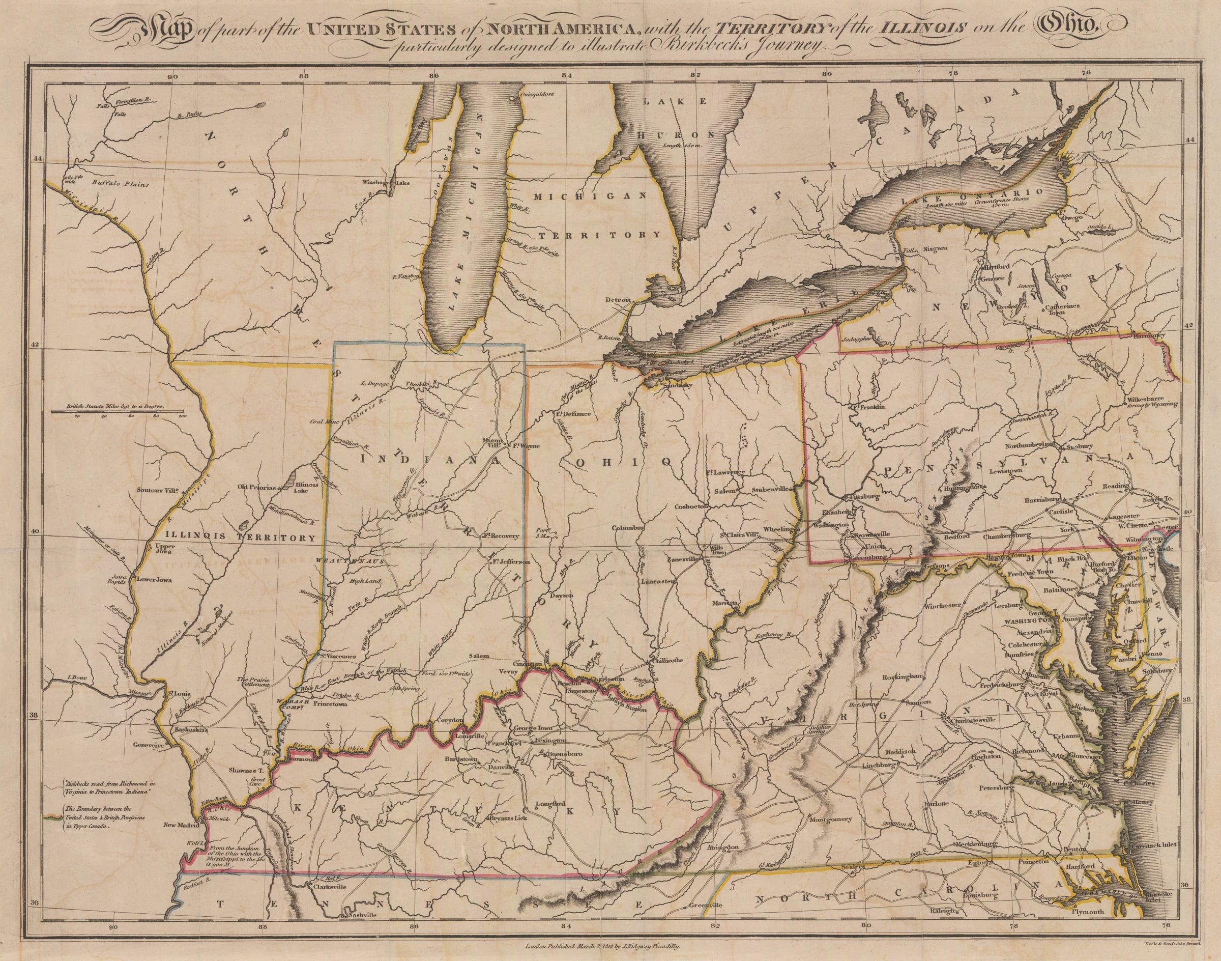
Morris Birkbeck
Early map of Ohio, Indiana and the Territory of Illinois, 1818
12 x 16 in
30 x 40 cm
30 x 40 cm
USA9507
£ 1,250.00
Morris Birkbeck, Early map of Ohio, Indiana and the Territory of Illinois, 1818
Sold
%3Cdiv%20class%3D%22artist%22%3EMorris%20Birkbeck%3C/div%3E%3Cdiv%20class%3D%22title_and_year%22%3E%3Cspan%20class%3D%22title_and_year_title%22%3EEarly%20map%20of%20Ohio%2C%20Indiana%20and%20the%20Territory%20of%20Illinois%3C/span%3E%2C%20%3Cspan%20class%3D%22title_and_year_year%22%3E1818%3C/span%3E%3C/div%3E%3Cdiv%20class%3D%22dimensions%22%3E12%20x%2016%20in%3Cbr/%3E%0A30%20x%2040%20cm%3C/div%3E
Map of part of the United States of North America with the Territory of Illinois on the Ohio particularly designed to illustrate Birkbeck's Journey An early and fascinating map...
Map of part of the United States of North America with the Territory of Illinois on the Ohio particularly designed to illustrate Birkbeck's Journey
An early and fascinating map of the mid-western States of Ohio, Indiana and the Territory of Illinois, in 1818 perceived as the Western frontier of the United States.
The map was issued within a work entitled “Notes on a Journey in America from the Coast of Virginia to the Territory of Illinois” by the pioneer, traveller and sometime statesman, Morris Birkbeck. The author had left England believing that the current political and religious climate was inimical to his beliefs as a Quaker and decided to emigrate to the United States. He had met Edward Coles, private secretary to American president James Madison in London and been influenced by his accounts of the lands and beauty of the newly established Illinois Territory. Birkbeck decided to convince his family, wards and several dependants to move with him and establish a Utopian settlement which would become the English Settlement on what became known as the English Prairie. To encourage further emigration, Birkbeck published this volume of his travels and experiences. It was hugely successful and caused a sensation when it was first published in 1817 with multiple editions in several languages published shortly afterwards.
The map focuses on the then western frontier; although it does show the old Northwest Territory, superimposed upon it are the newly established States of Ohio, Indiana and the Territory of Illinois which at this point was petitioning Congress for statehood. Due to a misreading of longitude, the map shows Illinois west of where it should be and without access to Lake Michigan. This was a persistent error that appeared on maps from this period influenced by the publication of the wall of the United States published by Aaron Arrowsmith. The map was also published shortly before a momentous decision by Congress which would re-organise the borders of the region; Nathaniel Pope, a lobbyist, convinced the authorities to move the northern border of Illinois approximately thirty miles north which allowed the newly established State access to Lake Michigan. Within this small shoreline was a small settlement often marked on maps as “Fort Chicagou”. Another point of interest on the map is the marking, in the southeast of the Territory, of the Prairie Settlement or Birkbeck’s Utopian settlement.
Although Birkbeck was a prodigious correspondent and wrote many letters on a variety of subjects, particularly abolition, this is the only map associated with his name.
Original colour. [USA9507]
Share
- Tumblr
Join our mailing list
* denotes required fields
We will process the personal data you have supplied to communicate with you in accordance with our Privacy Policy. You can unsubscribe or change your preferences at any time by clicking the link in our emails.
Contact
The Map House
54 Beauchamp Place,
London SW3 1NY,
United Kingdom
maps@themaphouse.com
+44 (0)20 7589 4325
![]()
Copyright © 2025 The Map House
This website uses cookies
This site uses cookies to help make it more useful to you. Please contact us to find out more about our Cookie Policy.