- All
- AFRICA
- ▪ Central Africa
- ▪ East Africa
- ▪ North Africa
- ▪ Southern Africa
- ▪ West Africa
- ▪ Atlantic Islands
- AMERICAS
-
▪ United States (USA)
- USA - East
- USA - Midwest
- USA - Northeast
- USA - Southeast
- USA - West & Southwest
- Alabama
- Alaska
- Arizona
- Arkansas
- California
- Colorado
- Connecticut
- Delaware
- Florida
- Georgia
- Hawaii
- Idaho
- Illinois
- Indiana
- Iowa
- Kansas
- Kentucky
- Louisiana
- Maine
- Maryland
- Massachusetts
- Michigan
- Minnesota
- Mississippi
- Missouri
- Montana
- Nebraska
- Nevada
- New Hampshire
- New Jersey
- New Mexico
- New York
- New York City
- North Carolina
- North Dakota
- Ohio
- Oklahoma
- Oregon
- Pennsylvania
- Rhode Island
- South Carolina
- South Dakota
- Tennessee
- Texas
- Utah
- Vermont
- Virginia
- Washington
- Washington, D.C.
- West Virginia
- Wisconsin
- Wyoming
- ▪ North America
- ▪ South America
- ▪ Caribbean
- ASIA
- ▪ East Asia
- ▪ Southeast Asia
- ▪ India & South Asia
- ▪ Middle East & Turkey
- BRITISH ISLES
- ▪ London
-
▪ England
- English Cities
- Bedfordshire
- Berkshire
- Buckinghamshire
- Cambridgeshire
- Cheshire
- Cornwall
- Cumbria
- Derbyshire
- Devon
- Dorset
- Durham
- Essex
- Gloucestershire
- Hampshire
- Herefordshire
- Hertfordshire
- Huntingdonshire
- Isle of Wight
- Kent
- Lancashire
- Leicestershire
- Lincolnshire
- Middlesex
- Norfolk
- Northamptonshire
- Northumberland
- Nottinghamshire
- Oxfordshire
- Rutland
- Shropshire
- Somerset
- Staffordshire
- Suffolk
- Surrey
- Sussex
- Warwickshire
- Wiltshire
- Worcestershire
- Yorkshire
- Yorkshire East Riding
- Yorkshire North Riding
- Yorkshire West Riding
- ▪ Ireland
- ▪ Scotland
- ▪ Wales
- EUROPE
- ▪ Austria & Switzerland
- ▪ Benelux Region
- ▪ Central & Eastern Europe
- ▪ France & Monaco
- ▪ Germany
- ▪ Greece
- ▪ Italy
- ▪ Mediterranean Sea
- ▪ Spain & Portugal
- ▪ Scandinavia & Baltics
- ▪ Russia, Ukraine & Caucasus
- OCEANIA
- ▪ Australia
- ▪ New Zealand
- ▪ Pacific Ocean & Islands
- ▪ Papua New Guinea
- POLAR
- CELESTIAL
- WORLD
- GLOBES & INSTRUMENTS
- THEMATIC
- COLLABORATIONS
Justus Perthes
26 x 30 cm
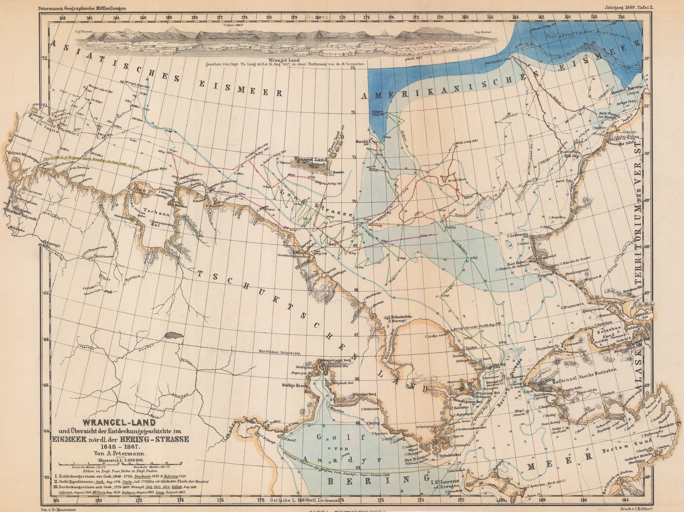
This attractive map is an overview of the exploration of the Arctic Sea north of the Behring Straits from Cook to Long in 1867.
The emphasis on the map is on the position of the elusive island named Wrangel Land or now Wrangel Island. It was named after Baron Ferdinand von Wrangel who searched for it unsuccessfully for three years. The Long is refers to Thomas Long, an American whaling captain, who approached close to the coastline and named the island out of respect for the unsuccessful search undertaken by Wrangel. It is now a Russian nature reserve.
The Geographische Mittheilungen, in which this map was originally published, is the oldest German language geographical journal - its first issue was in 1855 and it finally closed its doors in 2004. The magazine was conceived and edited by August Heinrich Petermann and published by the venerable firm of Justus Perthes in Gotha, Germany. Its first article reported on an expedition into North Africa and the Sahara by Heinrich Barth and Adolf Overweg. This report was enough to secure a circulation of 4000 for the fledgling magazine and, more importantly, encouraged other important scientist-explorers of the day who were attracted by the magazine’s heavy scientific emphasis to send in their own reports. These included Hans Meyer, the first man to ascend the Kibo crater on Mount Kilimanjaro, Sven Hedin, the Swedish explorer of Central Asia and the Himalayas, and Alfred Wegener, the geoscientist who pioneered the theory of continental shift which led to the modern theory of plate tectonics.
In comparison to its contemporaries, such as the Geographical Journal of the Royal Geographical Society, the Mittheilungen had a far greater interest in ethnography and the physical and natural sciences, leading to the inclusion of many fascinating, but sometimes obscure, maps on the most recent theories related to climatology, meteorology, botany, and zoology. Printed colour.
[AMER2383]
- X
- Tumblr
Join our mailing list
* denotes required fields
We will process the personal data you have supplied to communicate with you in accordance with our Privacy Policy. You can unsubscribe or change your preferences at any time by clicking the link in our emails.
Contact
The Map House
54 Beauchamp Place,
London SW3 1NY,
United Kingdom
maps@themaphouse.com
+44 (0)20 7589 4325
![]()
This website uses cookies
This site uses cookies to help make it more useful to you. Please contact us to find out more about our Cookie Policy.
Join our mailing list
* denotes required fields
We will process the personal data you have supplied to communicate with you in accordance with our Privacy Policy. You can unsubscribe or change your preferences at any time by clicking the link in our emails.