- All
- AFRICA
- ▪ Central Africa
- ▪ East Africa
- ▪ North Africa
- ▪ Southern Africa
- ▪ West Africa
- ▪ Atlantic Islands
- AMERICAS
-
▪ United States (USA)
- USA - East
- USA - Midwest
- USA - Northeast
- USA - Southeast
- USA - West & Southwest
- Alabama
- Alaska
- Arizona
- Arkansas
- California
- Colorado
- Connecticut
- Delaware
- Florida
- Georgia
- Hawaii
- Idaho
- Illinois
- Indiana
- Iowa
- Kansas
- Kentucky
- Louisiana
- Maine
- Maryland
- Massachusetts
- Michigan
- Minnesota
- Mississippi
- Missouri
- Montana
- Nebraska
- Nevada
- New Hampshire
- New Jersey
- New Mexico
- New York
- New York City
- North Carolina
- North Dakota
- Ohio
- Oklahoma
- Oregon
- Pennsylvania
- Rhode Island
- South Carolina
- South Dakota
- Tennessee
- Texas
- Utah
- Vermont
- Virginia
- Washington
- Washington, D.C.
- West Virginia
- Wisconsin
- Wyoming
- ▪ North America
- ▪ South America
- ▪ Caribbean
- ASIA
- ▪ East Asia
- ▪ Southeast Asia
- ▪ India & South Asia
- ▪ Middle East & Turkey
- BRITISH ISLES
- ▪ London
-
▪ England
- English Cities
- Bedfordshire
- Berkshire
- Buckinghamshire
- Cambridgeshire
- Cheshire
- Cornwall
- Cumbria
- Derbyshire
- Devon
- Dorset
- Durham
- Essex
- Gloucestershire
- Hampshire
- Herefordshire
- Hertfordshire
- Huntingdonshire
- Isle of Wight
- Kent
- Lancashire
- Leicestershire
- Lincolnshire
- Middlesex
- Norfolk
- Northamptonshire
- Northumberland
- Nottinghamshire
- Oxfordshire
- Rutland
- Shropshire
- Somerset
- Staffordshire
- Suffolk
- Surrey
- Sussex
- Warwickshire
- Wiltshire
- Worcestershire
- Yorkshire
- Yorkshire East Riding
- Yorkshire North Riding
- Yorkshire West Riding
- ▪ Ireland
- ▪ Scotland
- ▪ Wales
- EUROPE
- ▪ Austria & Switzerland
- ▪ Benelux Region
- ▪ Central & Eastern Europe
- ▪ France & Monaco
- ▪ Germany
- ▪ Greece
- ▪ Italy
- ▪ Mediterranean Sea
- ▪ Spain & Portugal
- ▪ Scandinavia & Baltics
- ▪ Russia, Ukraine & Caucasus
- OCEANIA
- ▪ Australia
- ▪ New Zealand
- ▪ Pacific Ocean & Islands
- ▪ Papua New Guinea
- POLAR
- CELESTIAL
- WORLD
- GLOBES & INSTRUMENTS
- THEMATIC
- COLLABORATIONS
Count Jean-Francois de la Perouse
Chart of the North Pacific, 1797
20 x 27 ½ in
51 x 70 cm
51 x 70 cm
AMER2378
£ 750.00
Count Jean-Francois de la Perouse, Chart of the North Pacific, 1797
Sold
%3Cdiv%20class%3D%22artist%22%3ECount%20Jean-Francois%20de%20la%20Perouse%3C/div%3E%3Cdiv%20class%3D%22title_and_year%22%3E%3Cspan%20class%3D%22title_and_year_title%22%3EChart%20of%20the%20North%20Pacific%3C/span%3E%2C%20%3Cspan%20class%3D%22title_and_year_year%22%3E1797%3C/span%3E%3C/div%3E%3Cdiv%20class%3D%22dimensions%22%3E20%20x%2027%20%C2%BD%20in%3Cbr/%3E%0A51%20x%2070%20cm%3C/div%3E
Carte de Cotes de L'Amerique et de L'Asie depuis la Californie jusqu'a Macao Chart of the North Pacific, tracking part of the voyage of Jean Francois de Galaup, Comte...
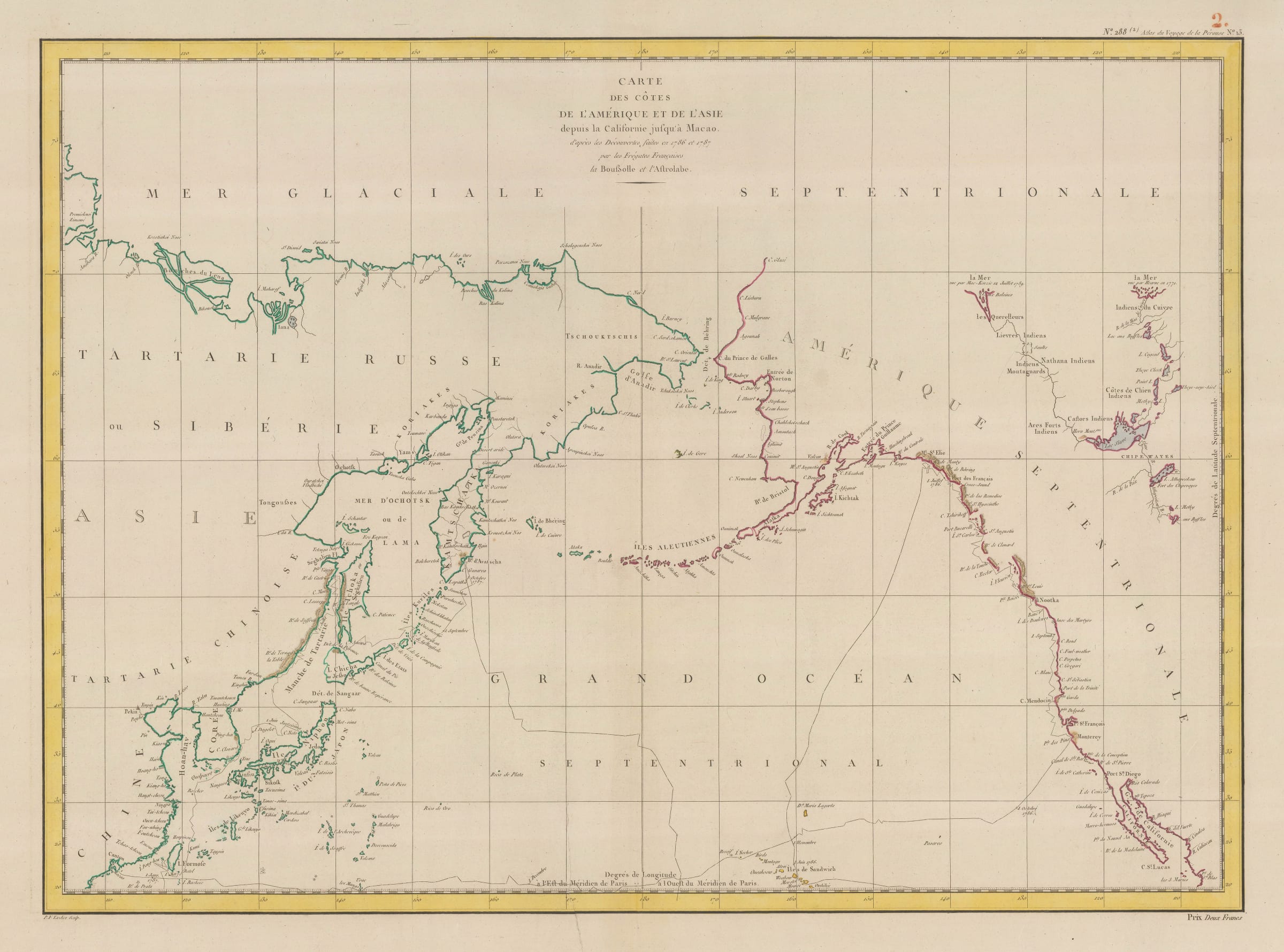
Carte de Cotes de L'Amerique et de L'Asie depuis la Californie jusqu'a Macao
Chart of the North Pacific, tracking part of the voyage of Jean Francois de Galaup, Comte de la Perouse.
Often compared to Cook, La Perouse sailed in the same waters and had the same aims. Ostensibly a scientific expedition, La Perouse was also secretly tasked to survey the possible areas for siting new French colonies in the Pacific, particularly Australia.
This chart shows La Perouse’s voyage in the North Pacific in 1786-7, first calling at Hawaii and then sailing to the northwest coast of America as far south as Monterrey, from where he turned west and sailed to Macao. From there, the expedition sailed north hugging the east coast of Asia until they reached the Kamchatka Peninsula. Upon reaching Petropavlovsk, the papers and results of the expedition so far were entrusted to crew member and interpreter, Barthelemy de Lesseps before La Perouse was informed that the English had sent a fleet to what they named New South Wales. La Perouse rapidly sailed south, only to find that the British had already landed in Port Jackson. After several cordial exchanges, this being one of the brief periods of peace between Britain and France, La Perouse sailed into the Pacific and contact with his ships was lost.
It was not until 1826 that a British whaling captain returned to Europe with several French artifacts which he obtained from the local inhabitants of the island of Vanikoro, in the Solomon Islands. In 1828, a French naval officer, Dumont D’Urville, returned to Paris with several other artifacts from the same source. De Lesseps confirmed that these were from the expedition. Early 21st century expeditions have established that both ships of the expedition were wrecked on the reefs of Vanikoro.
This chart shows Le Perouse’s track south to the west of the Sandwich Islands (Hawaii).
Coloured.
Share
- Tumblr
Join our mailing list
* denotes required fields
We will process the personal data you have supplied to communicate with you in accordance with our Privacy Policy. You can unsubscribe or change your preferences at any time by clicking the link in our emails.
Contact
The Map House
54 Beauchamp Place,
London SW3 1NY,
United Kingdom
maps@themaphouse.com
+44 (0)20 7589 4325
![]()
Copyright © 2025 The Map House
This website uses cookies
This site uses cookies to help make it more useful to you. Please contact us to find out more about our Cookie Policy.