- All
- AFRICA
- ▪ Central Africa
- ▪ East Africa
- ▪ North Africa
- ▪ Southern Africa
- ▪ West Africa
- ▪ Atlantic Islands
- AMERICAS
-
▪ United States (USA)
- USA - East
- USA - Midwest
- USA - Northeast
- USA - Southeast
- USA - West & Southwest
- Alabama
- Alaska
- Arizona
- Arkansas
- California
- Colorado
- Connecticut
- Delaware
- Florida
- Georgia
- Hawaii
- Idaho
- Illinois
- Indiana
- Iowa
- Kansas
- Kentucky
- Louisiana
- Maine
- Maryland
- Massachusetts
- Michigan
- Minnesota
- Mississippi
- Missouri
- Montana
- Nebraska
- Nevada
- New Hampshire
- New Jersey
- New Mexico
- New York
- New York City
- North Carolina
- North Dakota
- Ohio
- Oklahoma
- Oregon
- Pennsylvania
- Rhode Island
- South Carolina
- South Dakota
- Tennessee
- Texas
- Utah
- Vermont
- Virginia
- Washington
- Washington, D.C.
- West Virginia
- Wisconsin
- Wyoming
- ▪ North America
- ▪ South America
- ▪ Caribbean
- ASIA
- ▪ East Asia
- ▪ Southeast Asia
- ▪ India & South Asia
- ▪ Middle East & Turkey
- BRITISH ISLES
- ▪ London
-
▪ England
- English Cities
- Bedfordshire
- Berkshire
- Buckinghamshire
- Cambridgeshire
- Cheshire
- Cornwall
- Cumbria
- Derbyshire
- Devon
- Dorset
- Durham
- Essex
- Gloucestershire
- Hampshire
- Herefordshire
- Hertfordshire
- Huntingdonshire
- Isle of Wight
- Kent
- Lancashire
- Leicestershire
- Lincolnshire
- Middlesex
- Norfolk
- Northamptonshire
- Northumberland
- Nottinghamshire
- Oxfordshire
- Rutland
- Shropshire
- Somerset
- Staffordshire
- Suffolk
- Surrey
- Sussex
- Warwickshire
- Wiltshire
- Worcestershire
- Yorkshire
- Yorkshire East Riding
- Yorkshire North Riding
- Yorkshire West Riding
- ▪ Ireland
- ▪ Scotland
- ▪ Wales
- EUROPE
- ▪ Austria & Switzerland
- ▪ Benelux Region
- ▪ Central & Eastern Europe
- ▪ France & Monaco
- ▪ Germany
- ▪ Greece
- ▪ Italy
- ▪ Mediterranean Sea
- ▪ Spain & Portugal
- ▪ Scandinavia & Baltics
- ▪ Russia, Ukraine & Caucasus
- OCEANIA
- ▪ Australia
- ▪ New Zealand
- ▪ Pacific Ocean & Islands
- ▪ Papua New Guinea
- POLAR
- CELESTIAL
- WORLD
- GLOBES & INSTRUMENTS
- THEMATIC
- COLLABORATIONS
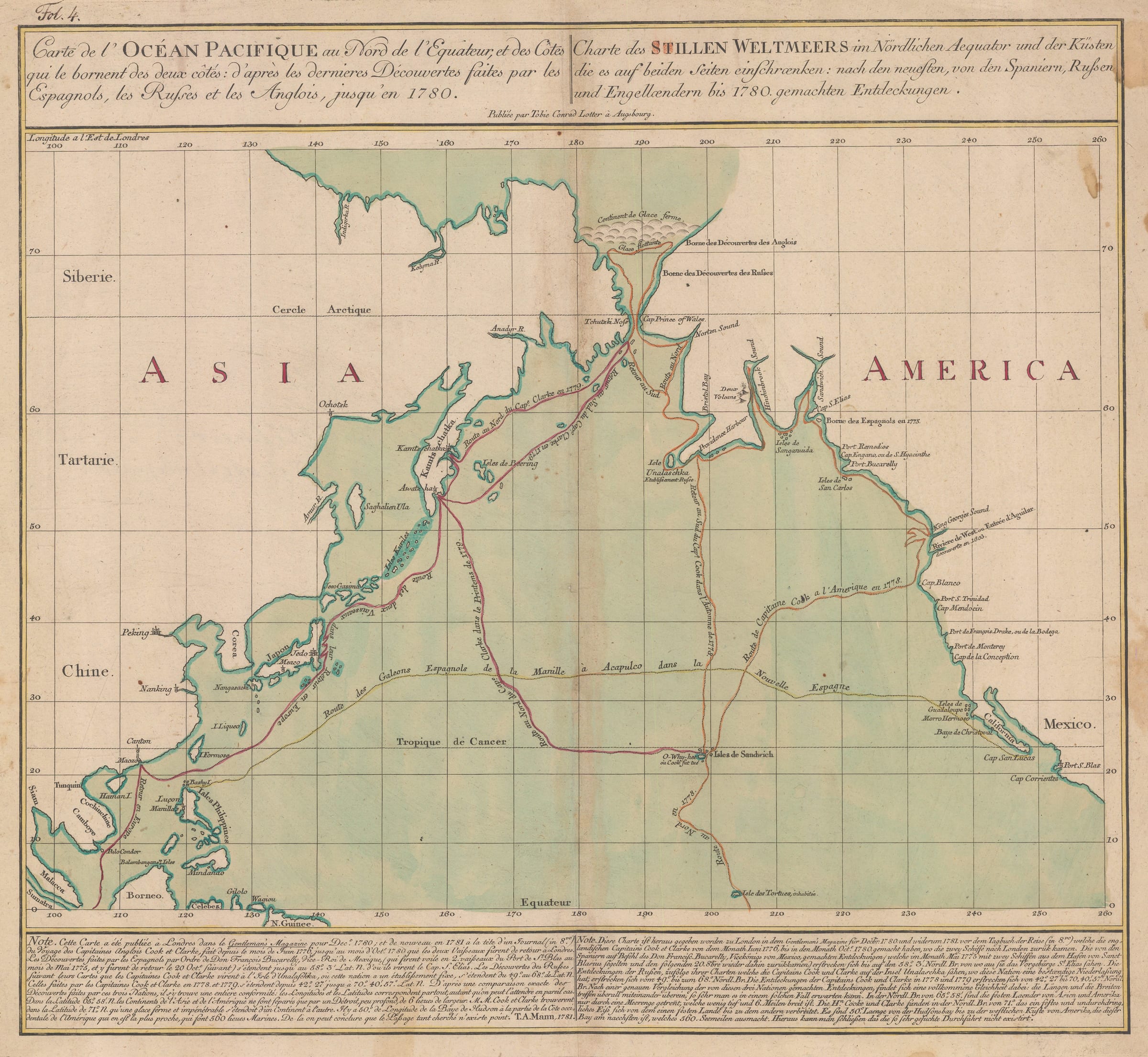
Tobias Conrad Lotter
47 x 51 cm
Striking map of the North Pacific Ocean area marking the routes taken by Captain James Cook (1728-1779), and of Captain Charles Clerke (1741-1779) during their third expedition (1776-1780).
Lotter’s notable map of the North Pacific is famous for several reasons. It is one of the earliest cartographic records of Cook’s ill-fated third voyage on which he lost his life. Corresponding with this, it is one of the earliest maps to show the Sandwich Islands or the modern Hawaiian Islands.
The map as a whole is titled as a document which reveals the latest discoveries in the North Pacific made by the English, the Spanish and the Russians to the year 1780. The panels on the lower part of the map refer to Spanish voyages under the supervision of Don Antonio Maria de Bucareli Y Ursua, Viceroy of Mexico, which originated in 1774 and reached the Pacific Northwest in 1775. They were a combination of exploratory voyages as well as a method for the Spanish to lay further claims to the Pacific coastline of North America and counter Russian claims further north. The panel also references Russian discoveries although these are more vague. These are references to the voyages made by Vitus Bering and Aleksey Chirikov. Although the Russian government was extremely secretive about both the Second Kamchatka Expedition and the Great Northern Expedition, Cook deemed Bering so important that he named the Straits between Asia and America after him.
However, the map is mainly associated with Cook as the ocean bears the route of Cook’s third voyage in orange along the Pacific Northwest coast and into the Behring Straits, records his death on the Sandwich Islands and then continues the voyage in red, this time under Cook’s successor, Captain Clarke, who sailed along the north eastern coast of Asia, before returning along roughly the same route and then back to Europe through Canton and the Indian Ocean.
This map was issued a full three years before the official publication of Cook’s last voyage in 1784. The panel on the lower part of the map states that its main source was a map published in the Gentleman’s Magazine in 1780. The date of this map is recorded, along with the engraver T. Mann, as 1781 at the end of the French section of the panel.
- X
- Tumblr
Join our mailing list
* denotes required fields
We will process the personal data you have supplied to communicate with you in accordance with our Privacy Policy. You can unsubscribe or change your preferences at any time by clicking the link in our emails.
Contact
The Map House
54 Beauchamp Place,
London SW3 1NY,
United Kingdom
maps@themaphouse.com
+44 (0)20 7589 4325
![]()
This website uses cookies
This site uses cookies to help make it more useful to you. Please contact us to find out more about our Cookie Policy.
Join our mailing list
* denotes required fields
We will process the personal data you have supplied to communicate with you in accordance with our Privacy Policy. You can unsubscribe or change your preferences at any time by clicking the link in our emails.