- All
- AFRICA
- ▪ Central Africa
- ▪ East Africa
- ▪ North Africa
- ▪ Southern Africa
- ▪ West Africa
- ▪ Atlantic Islands
- AMERICAS
-
▪ United States (USA)
- USA - East
- USA - Midwest
- USA - Northeast
- USA - Southeast
- USA - West & Southwest
- Alabama
- Alaska
- Arizona
- Arkansas
- California
- Colorado
- Connecticut
- Delaware
- Florida
- Georgia
- Hawaii
- Idaho
- Illinois
- Indiana
- Iowa
- Kansas
- Kentucky
- Louisiana
- Maine
- Maryland
- Massachusetts
- Michigan
- Minnesota
- Mississippi
- Missouri
- Montana
- Nebraska
- Nevada
- New Hampshire
- New Jersey
- New Mexico
- New York
- New York City
- North Carolina
- North Dakota
- Ohio
- Oklahoma
- Oregon
- Pennsylvania
- Rhode Island
- South Carolina
- South Dakota
- Tennessee
- Texas
- Utah
- Vermont
- Virginia
- Washington
- Washington, D.C.
- West Virginia
- Wisconsin
- Wyoming
- ▪ North America
- ▪ South America
- ▪ Caribbean
- ASIA
- ▪ East Asia
- ▪ Southeast Asia
- ▪ India & South Asia
- ▪ Middle East & Turkey
- BRITISH ISLES
- ▪ London
-
▪ England
- English Cities
- Bedfordshire
- Berkshire
- Buckinghamshire
- Cambridgeshire
- Cheshire
- Cornwall
- Cumbria
- Derbyshire
- Devon
- Dorset
- Durham
- Essex
- Gloucestershire
- Hampshire
- Herefordshire
- Hertfordshire
- Huntingdonshire
- Isle of Wight
- Kent
- Lancashire
- Leicestershire
- Lincolnshire
- Middlesex
- Norfolk
- Northamptonshire
- Northumberland
- Nottinghamshire
- Oxfordshire
- Rutland
- Shropshire
- Somerset
- Staffordshire
- Suffolk
- Surrey
- Sussex
- Warwickshire
- Wiltshire
- Worcestershire
- Yorkshire
- Yorkshire East Riding
- Yorkshire North Riding
- Yorkshire West Riding
- ▪ Ireland
- ▪ Scotland
- ▪ Wales
- EUROPE
- ▪ Austria & Switzerland
- ▪ Benelux Region
- ▪ Central & Eastern Europe
- ▪ France & Monaco
- ▪ Germany
- ▪ Greece
- ▪ Italy
- ▪ Mediterranean Sea
- ▪ Spain & Portugal
- ▪ Scandinavia & Baltics
- ▪ Russia, Ukraine & Caucasus
- OCEANIA
- ▪ Australia
- ▪ New Zealand
- ▪ Pacific Ocean & Islands
- ▪ Papua New Guinea
- POLAR
- CELESTIAL
- WORLD
- GLOBES & INSTRUMENTS
- THEMATIC
- COLLABORATIONS
Thomas Bowen
British and French Settlements in America, 1755
16 x 19 ½ in
41 x 49 cm
41 x 49 cm
USA9506
£ 4,500.00
Thomas Bowen, British and French Settlements in America, 1755
Sold
%3Cdiv%20class%3D%22artist%22%3EThomas%20Bowen%3C/div%3E%3Cdiv%20class%3D%22title_and_year%22%3E%3Cspan%20class%3D%22title_and_year_title%22%3EBritish%20and%20French%20Settlements%20in%20America%3C/span%3E%2C%20%3Cspan%20class%3D%22title_and_year_year%22%3E1755%3C/span%3E%3C/div%3E%3Cdiv%20class%3D%22dimensions%22%3E16%20x%2019%20%C2%BD%20in%3Cbr/%3E%0A41%20x%2049%20cm%3C/div%3E
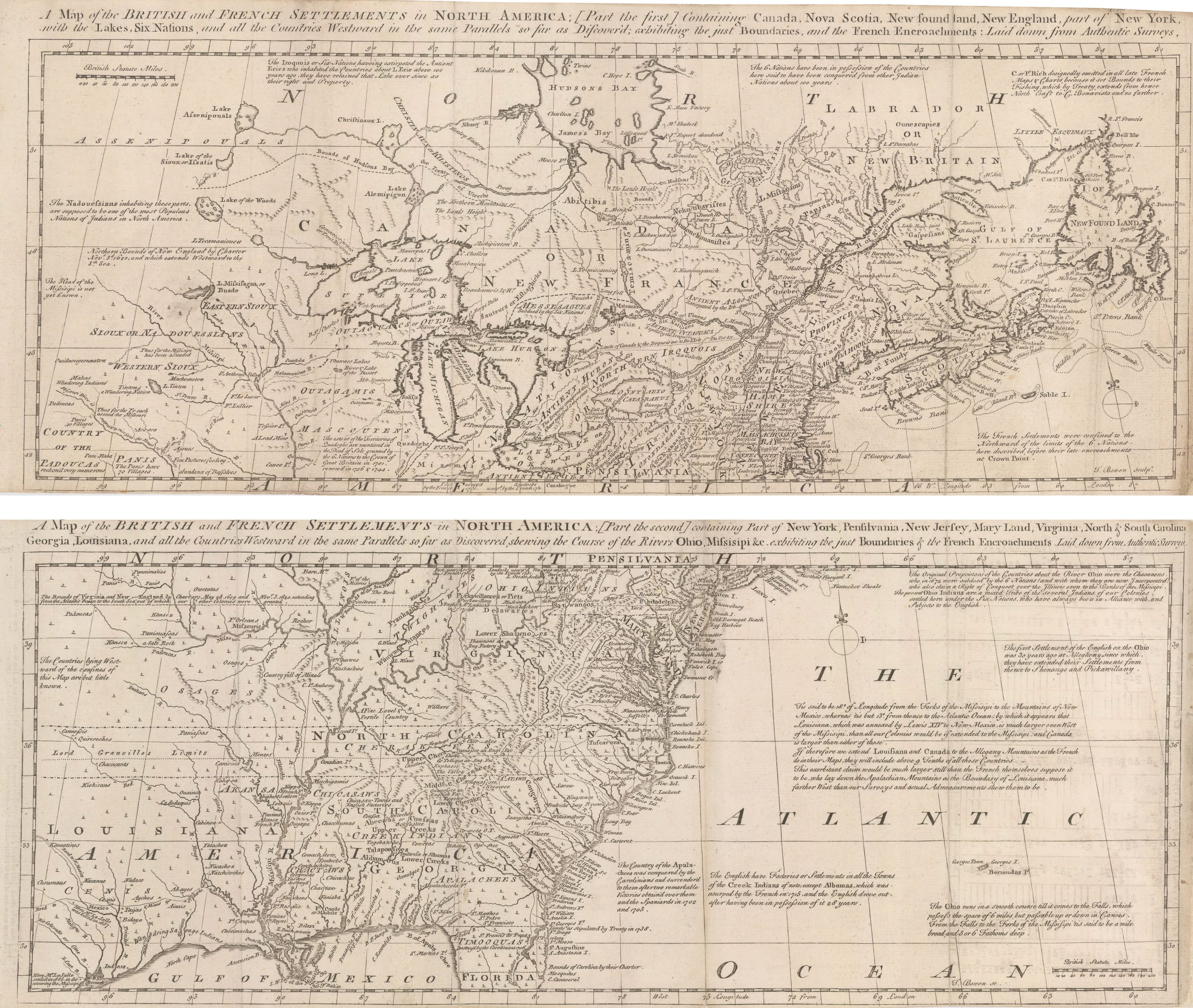
A Map of the British and French Settlements in North America [part the First] and A Map of the British and French Settlements in North America [part the Second] ...
A Map of the British and French Settlements in North America [part the First] and A Map of the British and French Settlements in North America [part the Second]
A pair of maps illustrating the British and French claims and colonies in North America at the outset of the French Indian War. Sold as a pair.
This rare pair for maps was issued at a critical juncture in the history of the United States. They were published together in the monthly issue of the General Magazine for Arts and Sciences in May 1755. This was a short-lived rival to more enduring popular publications of the same kind such as the Gentleman’s Magazine and the London Magazine. These were general gazetteers printing articles deemed of interest to the newly affluent merchant and professional classes emerging in the 18th century. Maps often played a leading role in illustrating these articles.
These maps were issued on the cusp of the French Indian War, or the North American theater of the much wider Seven Years War, often classed by historians as the first truly global conflict. Geographically, it covers the area from Hudson’s Bay to the Gulf coast north to south and from the east coast to modern Minnesota and the edge of Texas in the west. Fundamentally, this is a reduction of the monumental wall map of the same area published by John Mitchell, also in 1755. It also serves the same function as the Mitchell map, namely to introduce new discoveries, revise and update existing information and inform the educated public of the French encroachments into English Territory. Both maps are strong political statements. <br> <br>When the Mitchell map was first published, it caused a sensation and immediately superseded all maps of the same region published previously. As well as producing numerous derivatives, it was issued several times after the first 1755 issue and became the de facto cartographic document of authority for legal disputes, governments and settlements. Famously, a second edition of this map was used to settle the new borders of the United States after the American Revolutionary War.
As with the Mitchell map, the political information on this pair of maps is conveyed mainly through multiple text panels and annotations. They are too numerous to list individually but among the most interesting ones is the statement on the upper left on the second map what says “The bounds of Virginia and New England by Charters May 28 1609 and Nov. 3 1620 extending from the Atlantic Ocean to the South Sea out of which our other colonies were granted”. This is one of the few occasions where the British actually state that they believe their colonies stretched all the way through North America to the Pacific coast, including western Spanish territory. On a related note, another panel situated roughly in modern Minnesota and North Dakota states “Northern Bounds of New England by Charter Nov 3 1620 and which extends westwards to the Sth. Sea”.
All in all, this is one of few commercially available versions of the Mitchell map which is near contemporary. Each one of these maps is rare but it is even more unusual to find them as a pair.
[USA9506]
Share
- Tumblr
Join our mailing list
* denotes required fields
We will process the personal data you have supplied to communicate with you in accordance with our Privacy Policy. You can unsubscribe or change your preferences at any time by clicking the link in our emails.
Contact
The Map House
54 Beauchamp Place,
London SW3 1NY,
United Kingdom
maps@themaphouse.com
+44 (0)20 7589 4325
![]()
Copyright © 2025 The Map House
This website uses cookies
This site uses cookies to help make it more useful to you. Please contact us to find out more about our Cookie Policy.