- All
- AFRICA
- ▪ Central Africa
- ▪ East Africa
- ▪ North Africa
- ▪ Southern Africa
- ▪ West Africa
- ▪ Atlantic Islands
- AMERICAS
-
▪ United States (USA)
- USA - East
- USA - Midwest
- USA - Northeast
- USA - Southeast
- USA - West & Southwest
- Alabama
- Alaska
- Arizona
- Arkansas
- California
- Colorado
- Connecticut
- Delaware
- Florida
- Georgia
- Hawaii
- Idaho
- Illinois
- Indiana
- Iowa
- Kansas
- Kentucky
- Louisiana
- Maine
- Maryland
- Massachusetts
- Michigan
- Minnesota
- Mississippi
- Missouri
- Montana
- Nebraska
- Nevada
- New Hampshire
- New Jersey
- New Mexico
- New York
- New York City
- North Carolina
- North Dakota
- Ohio
- Oklahoma
- Oregon
- Pennsylvania
- Rhode Island
- South Carolina
- South Dakota
- Tennessee
- Texas
- Utah
- Vermont
- Virginia
- Washington
- Washington, D.C.
- West Virginia
- Wisconsin
- Wyoming
- ▪ North America
- ▪ South America
- ▪ Caribbean
- ASIA
- ▪ East Asia
- ▪ Southeast Asia
- ▪ India & South Asia
- ▪ Middle East & Turkey
- BRITISH ISLES
- ▪ London
-
▪ England
- English Cities
- Bedfordshire
- Berkshire
- Buckinghamshire
- Cambridgeshire
- Cheshire
- Cornwall
- Cumbria
- Derbyshire
- Devon
- Dorset
- Durham
- Essex
- Gloucestershire
- Hampshire
- Herefordshire
- Hertfordshire
- Huntingdonshire
- Isle of Wight
- Kent
- Lancashire
- Leicestershire
- Lincolnshire
- Middlesex
- Norfolk
- Northamptonshire
- Northumberland
- Nottinghamshire
- Oxfordshire
- Rutland
- Shropshire
- Somerset
- Staffordshire
- Suffolk
- Surrey
- Sussex
- Warwickshire
- Wiltshire
- Worcestershire
- Yorkshire
- Yorkshire East Riding
- Yorkshire North Riding
- Yorkshire West Riding
- ▪ Ireland
- ▪ Scotland
- ▪ Wales
- EUROPE
- ▪ Austria & Switzerland
- ▪ Benelux Region
- ▪ Central & Eastern Europe
- ▪ France & Monaco
- ▪ Germany
- ▪ Greece
- ▪ Italy
- ▪ Mediterranean Sea
- ▪ Spain & Portugal
- ▪ Scandinavia & Baltics
- ▪ Russia, Ukraine & Caucasus
- OCEANIA
- ▪ Australia
- ▪ New Zealand
- ▪ Pacific Ocean & Islands
- ▪ Papua New Guinea
- POLAR
- CELESTIAL
- WORLD
- GLOBES & INSTRUMENTS
- THEMATIC
- COLLABORATIONS
Laurie & Whittle
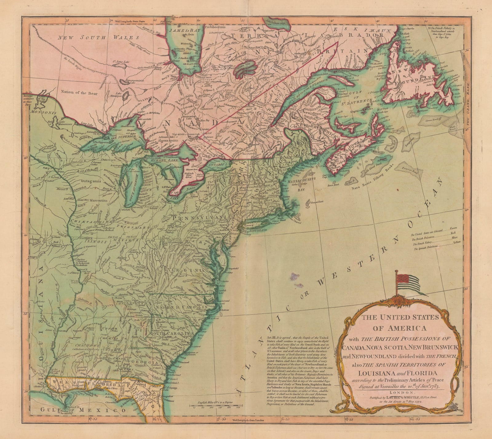
The United States of America, 1794
17 1/2 x 20 in
45 x 51 cm
45 x 51 cm
USA9333
£ 3,000.00
Laurie & Whittle, The United States of America, 1794
Sold
%3Cdiv%20class%3D%22artist%22%3ELaurie%20%26%20Whittle%3C/div%3E%3Cdiv%20class%3D%22title_and_year%22%3E%3Cspan%20class%3D%22title_and_year_title%22%3EThe%20United%20States%20of%20America%3C/span%3E%2C%20%3Cspan%20class%3D%22title_and_year_year%22%3E1794%3C/span%3E%3C/div%3E%3Cdiv%20class%3D%22dimensions%22%3E17%201/2%20x%2020%20in%3Cbr/%3E%0A45%20x%2051%20cm%3C/div%3E
The United States and Canada after the Treaty of Versailles which ended the Revolutionary War. Features one of the earliest depictions of the US flag with 13 stars on a...
The United States and Canada after the Treaty of Versailles which ended the Revolutionary War. Features one of the earliest depictions of the US flag with 13 stars on a printed map. Amusingly, the colourist has accidentally reversed the colours of the stars and stripes on the flag.
A paragraph of text to the left of the map's title contains the wording of Act III of the Treaty of Versailles. This section of the Treaty deals with fishing rights along the coast of the United States and Canada and how those fishing grounds would be shared between the Americans, the British, and the French. The Nova Scotia Banks, in particular, were one of the most important and lucrative sources of fish in the world at the time, which possibly explains why it is given such prominence on this map.
This map pre-dates the Louisiana Purchase of 1803, but the green colour indicating the United States continues far beyond the Mississippi River, the western boundary in 1794. Again, this is likely a mistake by the colourist rather than a political statement. The interior of the United States and Canada remained largely unexplored by Europeans at this point in history, so most of those portions of the map are filled with speculative mountain ranges, rivers, lakes, and the names of local Native American tribes who were thought to inhabit those regions.
Original hand-colour.
Share
- Tumblr
Join our mailing list
* denotes required fields
We will process the personal data you have supplied to communicate with you in accordance with our Privacy Policy. You can unsubscribe or change your preferences at any time by clicking the link in our emails.
Contact
The Map House
54 Beauchamp Place,
London SW3 1NY,
United Kingdom
maps@themaphouse.com
+44 (0)20 7589 4325

Copyright © 2025 The Map House
This website uses cookies
This site uses cookies to help make it more useful to you. Please contact us to find out more about our Cookie Policy.

