- All
- AFRICA
- ▪ Central Africa
- ▪ East Africa
- ▪ North Africa
- ▪ Southern Africa
- ▪ West Africa
- ▪ Atlantic Islands
- AMERICAS
-
▪ United States (USA)
- USA - East
- USA - Midwest
- USA - Northeast
- USA - Southeast
- USA - West & Southwest
- Alabama
- Alaska
- Arizona
- Arkansas
- California
- Colorado
- Connecticut
- Delaware
- Florida
- Georgia
- Hawaii
- Idaho
- Illinois
- Indiana
- Iowa
- Kansas
- Kentucky
- Louisiana
- Maine
- Maryland
- Massachusetts
- Michigan
- Minnesota
- Mississippi
- Missouri
- Montana
- Nebraska
- Nevada
- New Hampshire
- New Jersey
- New Mexico
- New York
- New York City
- North Carolina
- North Dakota
- Ohio
- Oklahoma
- Oregon
- Pennsylvania
- Rhode Island
- South Carolina
- South Dakota
- Tennessee
- Texas
- Utah
- Vermont
- Virginia
- Washington
- Washington, D.C.
- West Virginia
- Wisconsin
- Wyoming
- ▪ North America
- ▪ South America
- ▪ Caribbean
- ASIA
- ▪ East Asia
- ▪ Southeast Asia
- ▪ India & South Asia
- ▪ Middle East & Turkey
- BRITISH ISLES
- ▪ London
-
▪ England
- English Cities
- Bedfordshire
- Berkshire
- Buckinghamshire
- Cambridgeshire
- Cheshire
- Cornwall
- Cumbria
- Derbyshire
- Devon
- Dorset
- Durham
- Essex
- Gloucestershire
- Hampshire
- Herefordshire
- Hertfordshire
- Huntingdonshire
- Isle of Wight
- Kent
- Lancashire
- Leicestershire
- Lincolnshire
- Middlesex
- Norfolk
- Northamptonshire
- Northumberland
- Nottinghamshire
- Oxfordshire
- Rutland
- Shropshire
- Somerset
- Staffordshire
- Suffolk
- Surrey
- Sussex
- Warwickshire
- Wiltshire
- Worcestershire
- Yorkshire
- Yorkshire East Riding
- Yorkshire North Riding
- Yorkshire West Riding
- ▪ Ireland
- ▪ Scotland
- ▪ Wales
- EUROPE
- ▪ Austria & Switzerland
- ▪ Benelux Region
- ▪ Central & Eastern Europe
- ▪ France & Monaco
- ▪ Germany
- ▪ Greece
- ▪ Italy
- ▪ Mediterranean Sea
- ▪ Spain & Portugal
- ▪ Scandinavia & Baltics
- ▪ Russia, Ukraine & Caucasus
- OCEANIA
- ▪ Australia
- ▪ New Zealand
- ▪ Pacific Ocean & Islands
- ▪ Papua New Guinea
- POLAR
- CELESTIAL
- WORLD
- GLOBES & INSTRUMENTS
- THEMATIC
- COLLABORATIONS
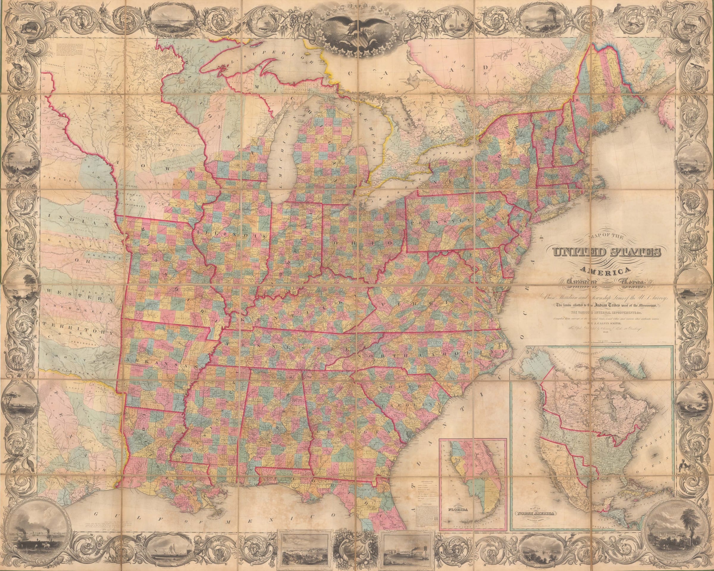
J. Calvin Smith
A Map of the United States of America, Canada and part of Texas, 1845
66 x 82 in
167 x 208 cm
167 x 208 cm
USA9227
%3Cdiv%20class%3D%22artist%22%3EJ.%20Calvin%20Smith%3C/div%3E%3Cdiv%20class%3D%22title_and_year%22%3E%3Cspan%20class%3D%22title_and_year_title%22%3EA%20Map%20of%20the%20United%20States%20of%20America%2C%20Canada%20and%20part%20of%20Texas%3C/span%3E%2C%20%3Cspan%20class%3D%22title_and_year_year%22%3E1845%3C/span%3E%3C/div%3E%3Cdiv%20class%3D%22dimensions%22%3E66%20x%2082%20in%3Cbr/%3E%0A167%20x%20208%20cm%3C/div%3E
Grand wall map of the United States as far west as Missouri, Arkansas and Louisiana. Large insets of North American and Florida. Very fine example of one of the largest...
Grand wall map of the United States as far west as Missouri, Arkansas and Louisiana. Large insets of North American and Florida.
Very fine example of one of the largest wall maps of the United States first issued just before the push for "Manifest Destiny". The extent of the country is depicted from the east coast to the western borders of the newly delineated states of Missouri, Arkansas and Louisiana. Above, Missouri, the tentative territory of Iowa is shown overlapping several Indian Lands including those of the Sacs and Foxes; north of those are the lands of the Sioux or Dakotas. Texas, on this date, is also treated as a separate entity since its declared independence from the United States and Mexico in 1836.
Aesthetically, the map is quite magnificent with an elaborate steel engraved border encompassing large vignettes of the major cities of the United States including New York, Baltimore, New Orleans and Charleston among others. These are interspersed with a floral motif adorned with wildlife while the whole map is crowned by a huge American Eagle on the upper centre. This element of elaborate decoration became highly influential with several important American map makers following this tradition, particularly on wall maps.
This map was first issued in 1843 as per the note under the title, published by Smith and his frequent collaborator, George Sherman. Although it has been cited that Smith based his geographical information mainly on John Arrowsmith, curiously, a note on the lower left of the map states that he sourced his information from the General Land Office, Washington DC endorsed by the Principal Clerk of Surveys, William T. Steiger. The map must have proved popular, as there are references to further editions in 1847 and 1849. The title of the map does not change but the date does. In 1853, the plate was sold to John Hutchins Colton who then issued the map again multiple times in the 1850s and 1860s but now bearing both Smith's and his name. The map also went through periodic geographical updates, best illustrated by the changes on the large inset of North America present on the lower right.
When the map was first issued in 1843, Texas was an independent Republic and California was part of Mexico. Multiple events, such as the territorial consequences of the settlement of the Mexican American War, the acceptance of Texas into the United States, the Gadsden Purchase and the Oregon Treaty which established the 49th parallel as the United States border in the north west are reflected on later editions of this map in a fascinating historical sequence.
This example is an early edition published in 1845 as shown on the title. The inset of North America reflects this by the clear delineation of the independent Republic of Texas, the American claim to the northwest border of the United States which includes a large section of British Columbia and the pre-Mexican American War southwestern border as agreed by the Adams Onis Treaty with Spain in 1819-21.
Finally, a note must be made about the condition and rarity of this map. Although all editions of this map are rare, there were more editions with the Colton imprint issued after 1853. It is also most unusual to find one in such fresh and pristine colour. Many of the institutional illustrations show a strong tendency to brown due either moisture or glue residue from the linen backing. Although there is a very light amount of soiling on the lower part of this map, comparatively this is inconsequential. The result is an object of great historical curiosity and astounding beauty.
Printed colour. Folded [USA9227]
Share
- Tumblr
Join our mailing list
* denotes required fields
We will process the personal data you have supplied to communicate with you in accordance with our Privacy Policy. You can unsubscribe or change your preferences at any time by clicking the link in our emails.
Contact
The Map House
54 Beauchamp Place,
London SW3 1NY,
United Kingdom
maps@themaphouse.com
+44 (0)20 7589 4325
![]()
Copyright © 2025 The Map House
This website uses cookies
This site uses cookies to help make it more useful to you. Please contact us to find out more about our Cookie Policy.