- All
- AFRICA
- ▪ Central Africa
- ▪ East Africa
- ▪ North Africa
- ▪ Southern Africa
- ▪ West Africa
- ▪ Atlantic Islands
- AMERICAS
-
▪ United States (USA)
- USA - East
- USA - Midwest
- USA - Northeast
- USA - Southeast
- USA - West & Southwest
- Alabama
- Alaska
- Arizona
- Arkansas
- California
- Colorado
- Connecticut
- Delaware
- Florida
- Georgia
- Hawaii
- Idaho
- Illinois
- Indiana
- Iowa
- Kansas
- Kentucky
- Louisiana
- Maine
- Maryland
- Massachusetts
- Michigan
- Minnesota
- Mississippi
- Missouri
- Montana
- Nebraska
- Nevada
- New Hampshire
- New Jersey
- New Mexico
- New York
- New York City
- North Carolina
- North Dakota
- Ohio
- Oklahoma
- Oregon
- Pennsylvania
- Rhode Island
- South Carolina
- South Dakota
- Tennessee
- Texas
- Utah
- Vermont
- Virginia
- Washington
- Washington, D.C.
- West Virginia
- Wisconsin
- Wyoming
- ▪ North America
- ▪ South America
- ▪ Caribbean
- ASIA
- ▪ East Asia
- ▪ Southeast Asia
- ▪ India & South Asia
- ▪ Middle East & Turkey
- BRITISH ISLES
- ▪ London
-
▪ England
- English Cities
- Bedfordshire
- Berkshire
- Buckinghamshire
- Cambridgeshire
- Cheshire
- Cornwall
- Cumbria
- Derbyshire
- Devon
- Dorset
- Durham
- Essex
- Gloucestershire
- Hampshire
- Herefordshire
- Hertfordshire
- Huntingdonshire
- Isle of Wight
- Kent
- Lancashire
- Leicestershire
- Lincolnshire
- Middlesex
- Norfolk
- Northamptonshire
- Northumberland
- Nottinghamshire
- Oxfordshire
- Rutland
- Shropshire
- Somerset
- Staffordshire
- Suffolk
- Surrey
- Sussex
- Warwickshire
- Wiltshire
- Worcestershire
- Yorkshire
- Yorkshire East Riding
- Yorkshire North Riding
- Yorkshire West Riding
- ▪ Ireland
- ▪ Scotland
- ▪ Wales
- EUROPE
- ▪ Austria & Switzerland
- ▪ Benelux Region
- ▪ Central & Eastern Europe
- ▪ France & Monaco
- ▪ Germany
- ▪ Greece
- ▪ Italy
- ▪ Mediterranean Sea
- ▪ Spain & Portugal
- ▪ Scandinavia & Baltics
- ▪ Russia, Ukraine & Caucasus
- OCEANIA
- ▪ Australia
- ▪ New Zealand
- ▪ Pacific Ocean & Islands
- ▪ Papua New Guinea
- POLAR
- CELESTIAL
- WORLD
- GLOBES & INSTRUMENTS
- THEMATIC
- COLLABORATIONS
G. De Kelsch
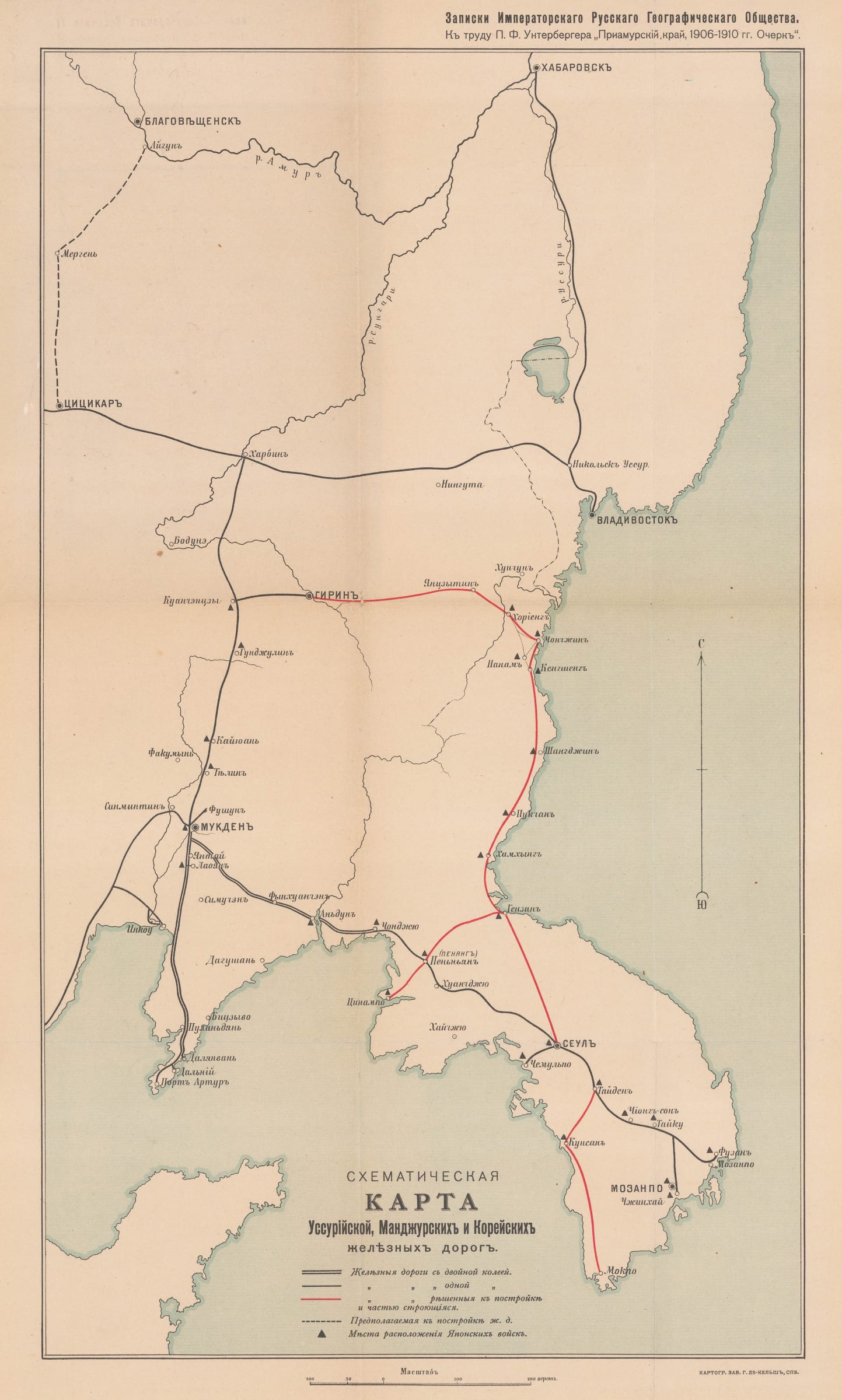
Russian schematic map of the Ussuriysk, Manchurian, and Korean Railroads, 1910 c.
18 ½ x 10 in
47 x 26 cm
47 x 26 cm
SEAS4308
£ 525.00
G. De Kelsch, Russian schematic map of the Ussuriysk, Manchurian, and Korean Railroads, 1910 c.
Sold
%3Cdiv%20class%3D%22artist%22%3EG.%20De%20Kelsch%3C/div%3E%3Cdiv%20class%3D%22title_and_year%22%3E%3Cspan%20class%3D%22title_and_year_title%22%3ERussian%20schematic%20map%20of%20the%20Ussuriysk%2C%20Manchurian%2C%20and%20Korean%20Railroads%3C/span%3E%2C%20%3Cspan%20class%3D%22title_and_year_year%22%3E1910%20c.%3C/span%3E%3C/div%3E%3Cdiv%20class%3D%22dimensions%22%3E18%20%C2%BD%20x%2010%20in%3Cbr/%3E%0A47%20x%2026%20cm%3C/div%3E
Схематическая карта Уссурийской, Манджурской и Корейской железных дорог. [Schematic map of the Ussuri, Mandzhur and Korean railways.] Russian schematic map of the Ussuriysk, Manchurian, and Korean Railroads published shortly...
Схематическая карта Уссурийской, Манджурской и Корейской железных дорог. [Schematic map of the Ussuri, Mandzhur and Korean railways.]
Russian schematic map of the Ussuriysk, Manchurian, and Korean Railroads published shortly after the Russo-Japanese War. Railways were an important tool for Russia's westward expansion and railway construction continued even after the Russian defeat against Japan. According to a key at the bottom of the map, double black lines indicates that two lines have been built, a single black line means that only one line has been built, red lines are routes currently under construction, and dashed lines are proposed, but not yet underway. The black triangles indicate the positions of Japanese troops, making Russia's continued military interest in this region plain.
Printed colour. [SEAS4308]
Share
- Tumblr
Join our mailing list
* denotes required fields
We will process the personal data you have supplied to communicate with you in accordance with our Privacy Policy. You can unsubscribe or change your preferences at any time by clicking the link in our emails.
Contact
The Map House
54 Beauchamp Place,
London SW3 1NY,
United Kingdom
maps@themaphouse.com
+44 (0)20 7589 4325
![]()
Copyright © 2025 The Map House
This website uses cookies
This site uses cookies to help make it more useful to you. Please contact us to find out more about our Cookie Policy.