- All
- AFRICA
- ▪ Central Africa
- ▪ East Africa
- ▪ North Africa
- ▪ Southern Africa
- ▪ West Africa
- ▪ Atlantic Islands
- AMERICAS
-
▪ United States (USA)
- USA - East
- USA - Midwest
- USA - Northeast
- USA - Southeast
- USA - West & Southwest
- Alabama
- Alaska
- Arizona
- Arkansas
- California
- Colorado
- Connecticut
- Delaware
- Florida
- Georgia
- Hawaii
- Idaho
- Illinois
- Indiana
- Iowa
- Kansas
- Kentucky
- Louisiana
- Maine
- Maryland
- Massachusetts
- Michigan
- Minnesota
- Mississippi
- Missouri
- Montana
- Nebraska
- Nevada
- New Hampshire
- New Jersey
- New Mexico
- New York
- New York City
- North Carolina
- North Dakota
- Ohio
- Oklahoma
- Oregon
- Pennsylvania
- Rhode Island
- South Carolina
- South Dakota
- Tennessee
- Texas
- Utah
- Vermont
- Virginia
- Washington
- Washington, D.C.
- West Virginia
- Wisconsin
- Wyoming
- ▪ North America
- ▪ South America
- ▪ Caribbean
- ASIA
- ▪ East Asia
- ▪ Southeast Asia
- ▪ India & South Asia
- ▪ Middle East & Turkey
- BRITISH ISLES
- ▪ London
-
▪ England
- English Cities
- Bedfordshire
- Berkshire
- Buckinghamshire
- Cambridgeshire
- Cheshire
- Cornwall
- Cumbria
- Derbyshire
- Devon
- Dorset
- Durham
- Essex
- Gloucestershire
- Hampshire
- Herefordshire
- Hertfordshire
- Huntingdonshire
- Isle of Wight
- Kent
- Lancashire
- Leicestershire
- Lincolnshire
- Middlesex
- Norfolk
- Northamptonshire
- Northumberland
- Nottinghamshire
- Oxfordshire
- Rutland
- Shropshire
- Somerset
- Staffordshire
- Suffolk
- Surrey
- Sussex
- Warwickshire
- Wiltshire
- Worcestershire
- Yorkshire
- Yorkshire East Riding
- Yorkshire North Riding
- Yorkshire West Riding
- ▪ Ireland
- ▪ Scotland
- ▪ Wales
- EUROPE
- ▪ Austria & Switzerland
- ▪ Benelux Region
- ▪ Central & Eastern Europe
- ▪ France & Monaco
- ▪ Germany
- ▪ Greece
- ▪ Italy
- ▪ Mediterranean Sea
- ▪ Spain & Portugal
- ▪ Scandinavia & Baltics
- ▪ Russia, Ukraine & Caucasus
- OCEANIA
- ▪ Australia
- ▪ New Zealand
- ▪ Pacific Ocean & Islands
- ▪ Papua New Guinea
- POLAR
- CELESTIAL
- WORLD
- GLOBES & INSTRUMENTS
- THEMATIC
- COLLABORATIONS
Nicolas Sanson
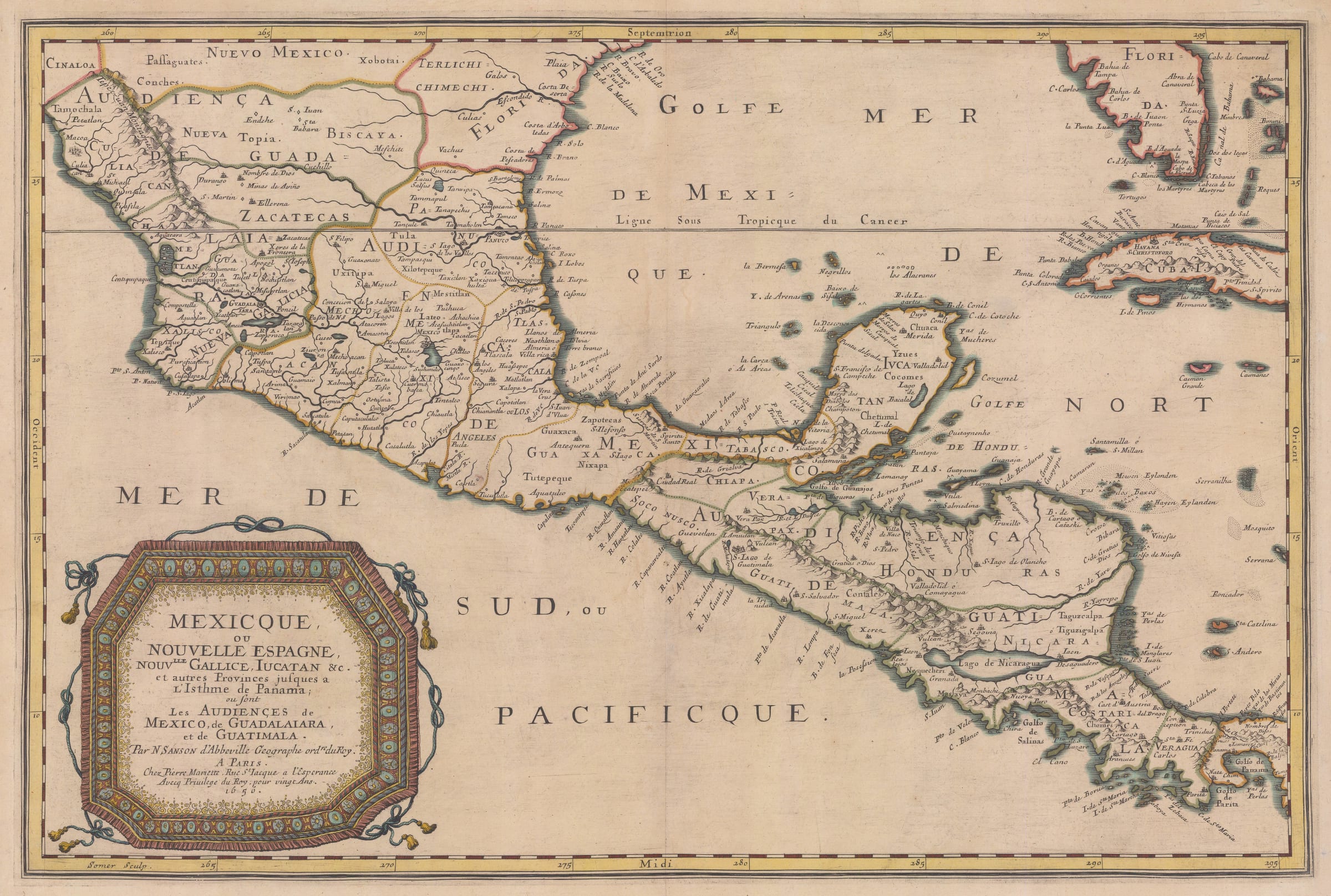
Mexico and Central America, 1656
15 x 22 in
38 x 56 cm
38 x 56 cm
WIND4301
£ 1,450.00
Nicolas Sanson, Mexico and Central America, 1656
Sold
%3Cdiv%20class%3D%22artist%22%3ENicolas%20Sanson%3C/div%3E%3Cdiv%20class%3D%22title_and_year%22%3E%3Cspan%20class%3D%22title_and_year_title%22%3EMexico%20and%20Central%20America%3C/span%3E%2C%20%3Cspan%20class%3D%22title_and_year_year%22%3E1656%3C/span%3E%3C/div%3E%3Cdiv%20class%3D%22dimensions%22%3E15%20x%2022%20in%3Cbr/%3E%0A38%20x%2056%20cm%3C/div%3E
Early map of the Spanish Viceroyalty of New Spain, stretching from Zacatecas in Mexico in the north to Guatemala in Central America in the south. This is one of the...
Early map of the Spanish Viceroyalty of New Spain, stretching from Zacatecas in Mexico in the north to Guatemala in Central America in the south.
This is one of the earliest available folio maps of the ancient Viceroyalty of New Spain. It was one of the linchpins of the Spanish Empire in the New World and at its height it comprised of both this area but also islands in the Caribbean and several other islands in the Pacific including the Philippines. The map was published before the French establishment of Louisiana, hence the north western border abuts to the neighbouring Spanish territory of Florida, here seen on both the Peninsula and the region mentioned above.
Among many points of geographical interest is the portrayal of Lake Nicaragua, with a large river draining from the lake into the Caribbean. On the western side, the lake almost reaches the Pacific shore, providing another great example of geographical wishful thinking for a sea route between the Pacific and the Atlantic.
Coloured. [WIND4301]
Share
- Tumblr
Join our mailing list
* denotes required fields
We will process the personal data you have supplied to communicate with you in accordance with our Privacy Policy. You can unsubscribe or change your preferences at any time by clicking the link in our emails.
Contact
The Map House
54 Beauchamp Place,
London SW3 1NY,
United Kingdom
maps@themaphouse.com
+44 (0)20 7589 4325
![]()
Copyright © 2025 The Map House
This website uses cookies
This site uses cookies to help make it more useful to you. Please contact us to find out more about our Cookie Policy.