- All
- AFRICA
- ▪ Central Africa
- ▪ East Africa
- ▪ North Africa
- ▪ Southern Africa
- ▪ West Africa
- ▪ Atlantic Islands
- AMERICAS
-
▪ United States (USA)
- USA - East
- USA - Midwest
- USA - Northeast
- USA - Southeast
- USA - West & Southwest
- Alabama
- Alaska
- Arizona
- Arkansas
- California
- Colorado
- Connecticut
- Delaware
- Florida
- Georgia
- Hawaii
- Idaho
- Illinois
- Indiana
- Iowa
- Kansas
- Kentucky
- Louisiana
- Maine
- Maryland
- Massachusetts
- Michigan
- Minnesota
- Mississippi
- Missouri
- Montana
- Nebraska
- Nevada
- New Hampshire
- New Jersey
- New Mexico
- New York
- New York City
- North Carolina
- North Dakota
- Ohio
- Oklahoma
- Oregon
- Pennsylvania
- Rhode Island
- South Carolina
- South Dakota
- Tennessee
- Texas
- Utah
- Vermont
- Virginia
- Washington
- Washington, D.C.
- West Virginia
- Wisconsin
- Wyoming
- ▪ North America
- ▪ South America
- ▪ Caribbean
- ASIA
- ▪ East Asia
- ▪ Southeast Asia
- ▪ India & South Asia
- ▪ Middle East & Turkey
- BRITISH ISLES
- ▪ London
-
▪ England
- English Cities
- Bedfordshire
- Berkshire
- Buckinghamshire
- Cambridgeshire
- Cheshire
- Cornwall
- Cumbria
- Derbyshire
- Devon
- Dorset
- Durham
- Essex
- Gloucestershire
- Hampshire
- Herefordshire
- Hertfordshire
- Huntingdonshire
- Isle of Wight
- Kent
- Lancashire
- Leicestershire
- Lincolnshire
- Middlesex
- Norfolk
- Northamptonshire
- Northumberland
- Nottinghamshire
- Oxfordshire
- Rutland
- Shropshire
- Somerset
- Staffordshire
- Suffolk
- Surrey
- Sussex
- Warwickshire
- Wiltshire
- Worcestershire
- Yorkshire
- Yorkshire East Riding
- Yorkshire North Riding
- Yorkshire West Riding
- ▪ Ireland
- ▪ Scotland
- ▪ Wales
- EUROPE
- ▪ Austria & Switzerland
- ▪ Benelux Region
- ▪ Central & Eastern Europe
- ▪ France & Monaco
- ▪ Germany
- ▪ Greece
- ▪ Italy
- ▪ Mediterranean Sea
- ▪ Spain & Portugal
- ▪ Scandinavia & Baltics
- ▪ Russia, Ukraine & Caucasus
- OCEANIA
- ▪ Australia
- ▪ New Zealand
- ▪ Pacific Ocean & Islands
- ▪ Papua New Guinea
- POLAR
- CELESTIAL
- WORLD
- GLOBES & INSTRUMENTS
- THEMATIC
- COLLABORATIONS
War Office
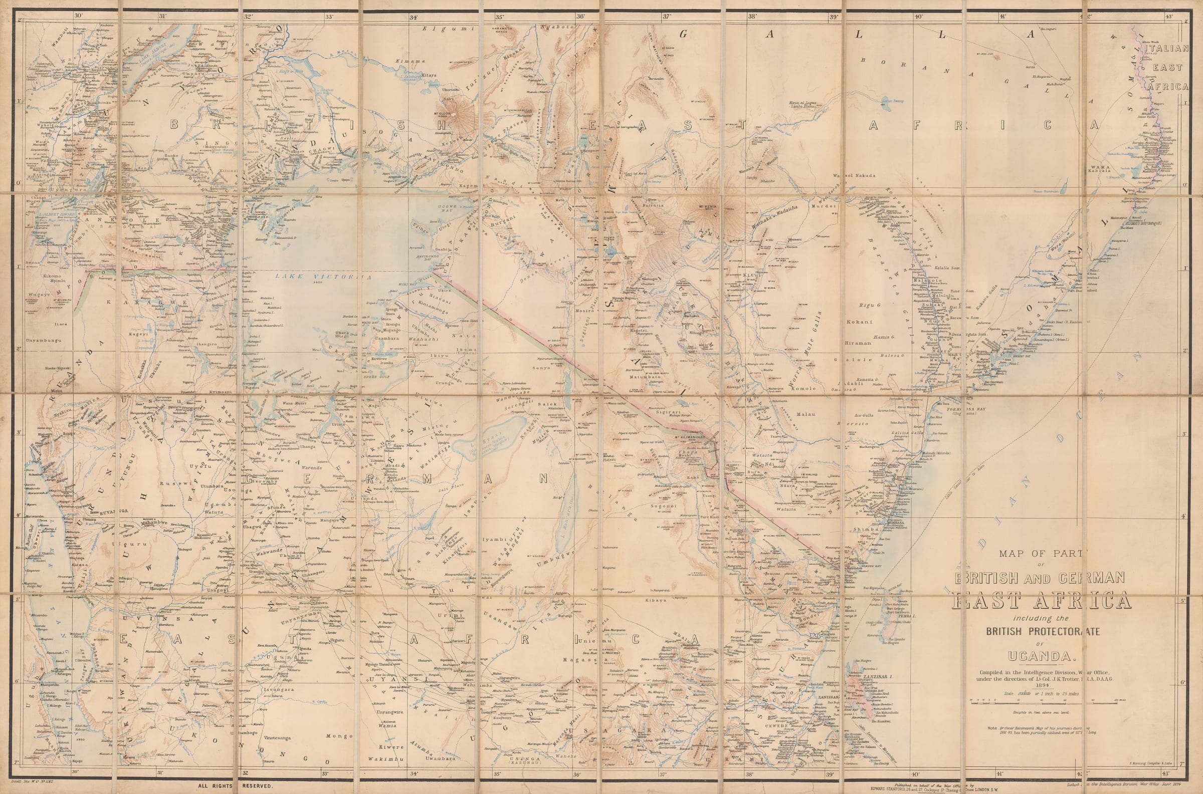
Map of Part of British and German East Africa including the British Protectorate of Uganda, 1894
26 ½ x 40 in
67 x 102 cm
67 x 102 cm
AFR6138
£ 1,650.00
War Office, Map of Part of British and German East Africa including the British Protectorate of Uganda, 1894
Sold
%3Cdiv%20class%3D%22artist%22%3EWar%20Office%3C/div%3E%3Cdiv%20class%3D%22title_and_year%22%3E%3Cspan%20class%3D%22title_and_year_title%22%3EMap%20of%20Part%20of%20British%20and%20German%20East%20Africa%20including%20the%20British%20Protectorate%20of%20Uganda%3C/span%3E%2C%20%3Cspan%20class%3D%22title_and_year_year%22%3E1894%3C/span%3E%3C/div%3E%3Cdiv%20class%3D%22dimensions%22%3E26%20%C2%BD%20x%2040%20in%3Cbr/%3E%0A67%20x%20102%20cm%3C/div%3E
Large-scale folding map of British and German East Africa (modern-day Kenya and Tanzania), reaching from the coast to Lake Victoria. Mt Kilimanjaro and Mt Kenya are both included. This map...
Large-scale folding map of British and German East Africa (modern-day Kenya and Tanzania), reaching from the coast to Lake Victoria. Mt Kilimanjaro and Mt Kenya are both included.
This map was compiled by the Intelligence Division of the War Office to improve the official British maps of this important colonial region. There were numerous minor skirmishes and conflicts between the British and the local kingdoms during the 1880s and 1890s, including a civil war in Buganda (Uganda) in 1893 and two Matabele Wars in Rhodesia (1893 and 1896). There was also tension between the British and their colonial rivals, the French and the Germans, which at times looked like it might erupt into open war.
Military readiness relied on accurate mapping, hence the production of these excellent military survey maps. Though much remains unexplored and uncharted, these maps are a valuable compilation of the very best knowledge of the day.
Printed colour. [SL]
Share
- Tumblr
Join our mailing list
* denotes required fields
We will process the personal data you have supplied to communicate with you in accordance with our Privacy Policy. You can unsubscribe or change your preferences at any time by clicking the link in our emails.
Contact
The Map House
54 Beauchamp Place,
London SW3 1NY,
United Kingdom
maps@themaphouse.com
+44 (0)20 7589 4325
![]()
Copyright © 2025 The Map House
This website uses cookies
This site uses cookies to help make it more useful to you. Please contact us to find out more about our Cookie Policy.