- All
- AFRICA
- ▪ Central Africa
- ▪ East Africa
- ▪ North Africa
- ▪ Southern Africa
- ▪ West Africa
- ▪ Atlantic Islands
- AMERICAS
-
▪ United States (USA)
- USA - East
- USA - Midwest
- USA - Northeast
- USA - Southeast
- USA - West & Southwest
- Alabama
- Alaska
- Arizona
- Arkansas
- California
- Colorado
- Connecticut
- Delaware
- Florida
- Georgia
- Hawaii
- Idaho
- Illinois
- Indiana
- Iowa
- Kansas
- Kentucky
- Louisiana
- Maine
- Maryland
- Massachusetts
- Michigan
- Minnesota
- Mississippi
- Missouri
- Montana
- Nebraska
- Nevada
- New Hampshire
- New Jersey
- New Mexico
- New York
- New York City
- North Carolina
- North Dakota
- Ohio
- Oklahoma
- Oregon
- Pennsylvania
- Rhode Island
- South Carolina
- South Dakota
- Tennessee
- Texas
- Utah
- Vermont
- Virginia
- Washington
- Washington, D.C.
- West Virginia
- Wisconsin
- Wyoming
- ▪ North America
- ▪ South America
- ▪ Caribbean
- ASIA
- ▪ East Asia
- ▪ Southeast Asia
- ▪ India & South Asia
- ▪ Middle East & Turkey
- BRITISH ISLES
- ▪ London
-
▪ England
- English Cities
- Bedfordshire
- Berkshire
- Buckinghamshire
- Cambridgeshire
- Cheshire
- Cornwall
- Cumbria
- Derbyshire
- Devon
- Dorset
- Durham
- Essex
- Gloucestershire
- Hampshire
- Herefordshire
- Hertfordshire
- Huntingdonshire
- Isle of Wight
- Kent
- Lancashire
- Leicestershire
- Lincolnshire
- Middlesex
- Norfolk
- Northamptonshire
- Northumberland
- Nottinghamshire
- Oxfordshire
- Rutland
- Shropshire
- Somerset
- Staffordshire
- Suffolk
- Surrey
- Sussex
- Warwickshire
- Wiltshire
- Worcestershire
- Yorkshire
- Yorkshire East Riding
- Yorkshire North Riding
- Yorkshire West Riding
- ▪ Ireland
- ▪ Scotland
- ▪ Wales
- EUROPE
- ▪ Austria & Switzerland
- ▪ Benelux Region
- ▪ Central & Eastern Europe
- ▪ France & Monaco
- ▪ Germany
- ▪ Greece
- ▪ Italy
- ▪ Mediterranean Sea
- ▪ Spain & Portugal
- ▪ Scandinavia & Baltics
- ▪ Russia, Ukraine & Caucasus
- OCEANIA
- ▪ Australia
- ▪ New Zealand
- ▪ Pacific Ocean & Islands
- ▪ Papua New Guinea
- POLAR
- CELESTIAL
- WORLD
- GLOBES & INSTRUMENTS
- THEMATIC
- COLLABORATIONS
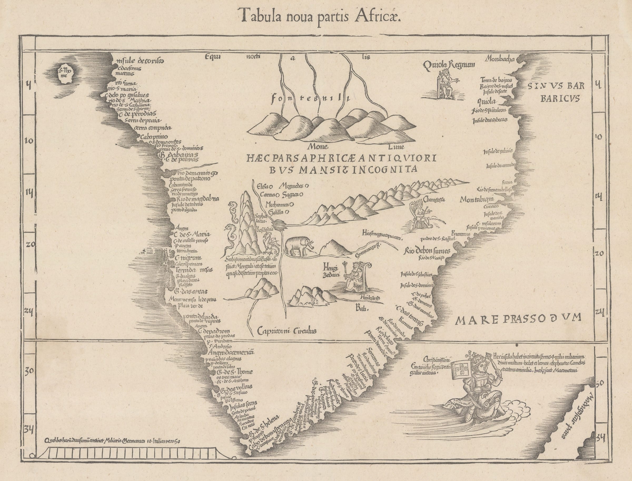
Martin Waldseemüller & Laurent Fries
The Second Printed Map of Southern Africa, 1541
14 1/2 x 18 1/2 in
37 x 47 cm
37 x 47 cm
AFR3972
£ 4,950.00
Martin Waldseemüller & Laurent Fries, The Second Printed Map of Southern Africa, 1541
Sold
%3Cdiv%20class%3D%22artist%22%3EMartin%20Waldseem%C3%BCller%20%26%20Laurent%20Fries%3C/div%3E%3Cdiv%20class%3D%22title_and_year%22%3E%3Cspan%20class%3D%22title_and_year_title%22%3EThe%20Second%20Printed%20Map%20of%20Southern%20Africa%3C/span%3E%2C%20%3Cspan%20class%3D%22title_and_year_year%22%3E1541%3C/span%3E%3C/div%3E%3Cdiv%20class%3D%22dimensions%22%3E14%201/2%20x%2018%201/2%20in%3Cbr/%3E%0A37%20x%2047%20cm%3C/div%3E
Tabula nova partis Africae The second-earliest map of Southern Africa, predated only by Martin Waldseemuller's rare map of 1513. Laurent Fries published this slightly reduced version of Waldseemuller's map...
Tabula nova partis Africae
The second-earliest map of Southern Africa, predated only by Martin Waldseemuller's rare map of 1513. Laurent Fries published this slightly reduced version of Waldseemuller's map with added illustrated vignettes in his updated editions of Ptolemy's Geographia starting in 1522. The 1541 edition is distinguished by the woodblock title which reads "Tabula noua partis Africae".
In recognition of Vasco da Gama's successful rounding of the Cape of Good Hope, the King Manuel I of Portugal is shown triumphantly riding a dolphin into the Indian Ocean to claim the land for Christendom. The unknown interior of the continent is filled with imaginary lakes, mountain ranges, and creatures, as well as miniature depictions of three African kings. The source of the Nile is shown as the Mons Lune, the Mountains of the Moon.
Reference: [Karrow (R.W.): Mapmakers of the Sixteenth Century 28/41] [AFR3972]
Share
- Tumblr
1
of
181
Join our mailing list
* denotes required fields
We will process the personal data you have supplied to communicate with you in accordance with our Privacy Policy. You can unsubscribe or change your preferences at any time by clicking the link in our emails.
Contact
The Map House
54 Beauchamp Place,
London SW3 1NY,
United Kingdom
maps@themaphouse.com
+44 (0)20 7589 4325
![]()
Copyright © 2025 The Map House
This website uses cookies
This site uses cookies to help make it more useful to you. Please contact us to find out more about our Cookie Policy.