- All
- AFRICA
- ▪ Central Africa
- ▪ East Africa
- ▪ North Africa
- ▪ Southern Africa
- ▪ West Africa
- ▪ Atlantic Islands
- AMERICAS
-
▪ United States (USA)
- USA - East
- USA - Midwest
- USA - Northeast
- USA - Southeast
- USA - West & Southwest
- Alabama
- Alaska
- Arizona
- Arkansas
- California
- Colorado
- Connecticut
- Delaware
- Florida
- Georgia
- Hawaii
- Idaho
- Illinois
- Indiana
- Iowa
- Kansas
- Kentucky
- Louisiana
- Maine
- Maryland
- Massachusetts
- Michigan
- Minnesota
- Mississippi
- Missouri
- Montana
- Nebraska
- Nevada
- New Hampshire
- New Jersey
- New Mexico
- New York
- New York City
- North Carolina
- North Dakota
- Ohio
- Oklahoma
- Oregon
- Pennsylvania
- Rhode Island
- South Carolina
- South Dakota
- Tennessee
- Texas
- Utah
- Vermont
- Virginia
- Washington
- Washington, D.C.
- West Virginia
- Wisconsin
- Wyoming
- ▪ North America
- ▪ South America
- ▪ Caribbean
- ASIA
- ▪ East Asia
- ▪ Southeast Asia
- ▪ India & South Asia
- ▪ Middle East & Turkey
- BRITISH ISLES
- ▪ London
-
▪ England
- English Cities
- Bedfordshire
- Berkshire
- Buckinghamshire
- Cambridgeshire
- Cheshire
- Cornwall
- Cumbria
- Derbyshire
- Devon
- Dorset
- Durham
- Essex
- Gloucestershire
- Hampshire
- Herefordshire
- Hertfordshire
- Huntingdonshire
- Isle of Wight
- Kent
- Lancashire
- Leicestershire
- Lincolnshire
- Middlesex
- Norfolk
- Northamptonshire
- Northumberland
- Nottinghamshire
- Oxfordshire
- Rutland
- Shropshire
- Somerset
- Staffordshire
- Suffolk
- Surrey
- Sussex
- Warwickshire
- Wiltshire
- Worcestershire
- Yorkshire
- Yorkshire East Riding
- Yorkshire North Riding
- Yorkshire West Riding
- ▪ Ireland
- ▪ Scotland
- ▪ Wales
- EUROPE
- ▪ Austria & Switzerland
- ▪ Benelux Region
- ▪ Central & Eastern Europe
- ▪ France & Monaco
- ▪ Germany
- ▪ Greece
- ▪ Italy
- ▪ Mediterranean Sea
- ▪ Spain & Portugal
- ▪ Scandinavia & Baltics
- ▪ Russia, Ukraine & Caucasus
- OCEANIA
- ▪ Australia
- ▪ New Zealand
- ▪ Pacific Ocean & Islands
- ▪ Papua New Guinea
- POLAR
- CELESTIAL
- WORLD
- GLOBES & INSTRUMENTS
- THEMATIC
- COLLABORATIONS
Jacques-Nicolas Bellin
58 x 91 cm
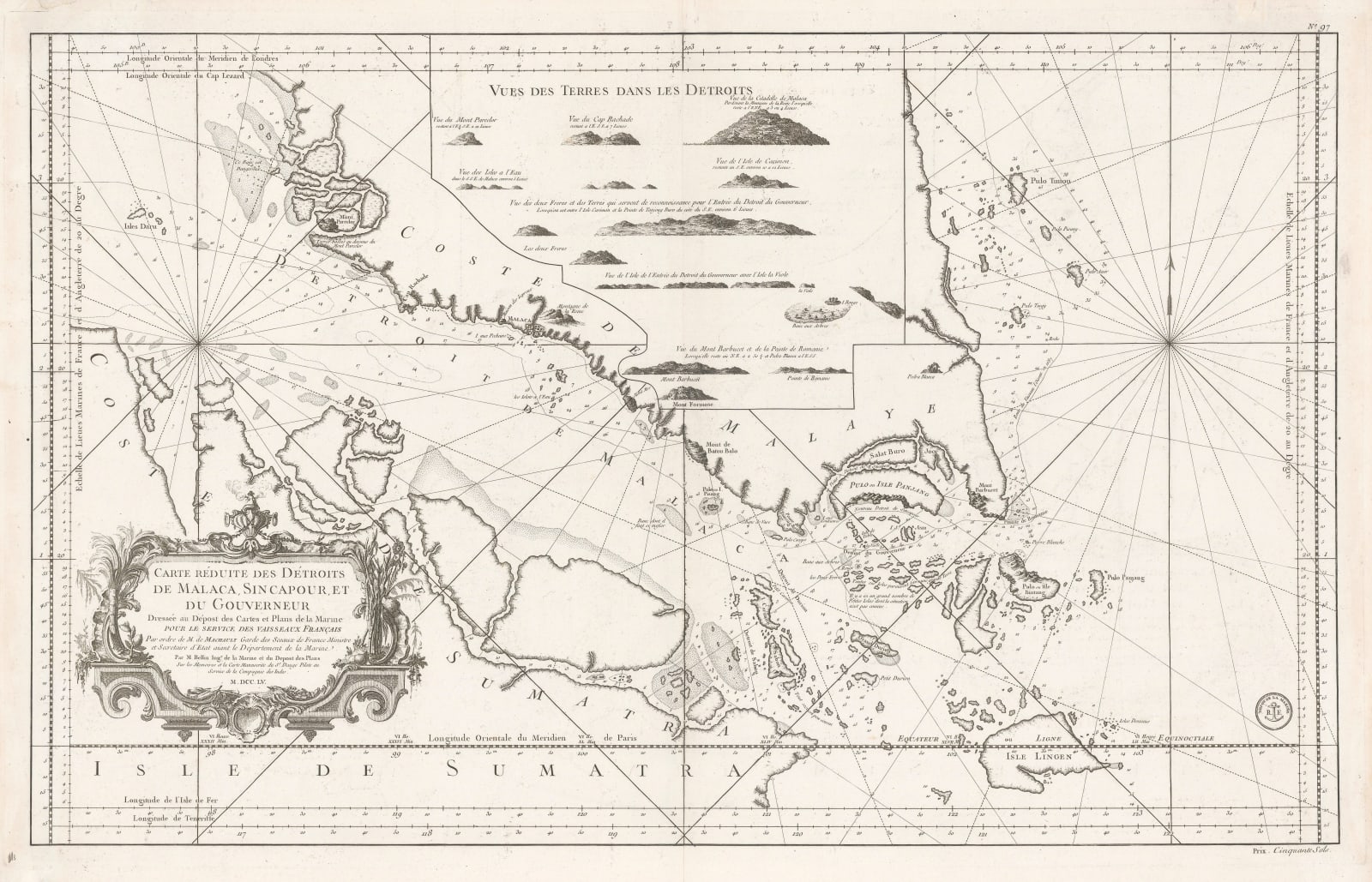
Singapore, the Straits of Malacca and contiguous islands. A rare chart of the region with detailed coastal views placed in the centre of Malaysia.
This exceptional map of southern Malaysia, Johore and Singapore with the Straits was issued in 1755 by the Depot de la Marine or French Admiralty; at this time, Bellin was the "Ingenieur de la Marine" as well as Hydrographer to the King.
As well as the areas mentioned above, the map also details the many islands of the region, including Pulo Bintang or Pulau Bintan, Pulo Timon or Pulau Tioman as well as Isle Panjang, a very early and rough depiction of Singapore Island. Despite its remarkable accuracy for a mid 18th century map of the region, Bellin makes various comments throughout the region stating that much information about the islands and region is still unknown.
One individual is credited as a major source for the map in the cartouche: "Pilote Dauge" of the French East India Company.
Finally, a ship's route is marked around the Peninsula. The vessel "Oiseaux" took a Jesuit Mission to China between 1687-8. The expedition was led by Alexandre, Chevalier du Chaumont who visited the King of Siam, Narai the Great as French ambassador from Louis XIV and attempted, without success, to convert him to Catholicism. The expedition also included the Abbee de Choisy, a scandalous figure known as a master of intrigue, cross-dresser and famous female impersonator and the Jesuit Guy de Tachard. Several of the participants of the expedition wrote accounts of their experiences and the official account became a source for scientific, artistic, geographical and historical information about the region for more than half a century; hence the presence of the ship's route on a map of 1755.
This is one of the great early maps of the Straits of Malacca and Singapore. [SEAS5415]
- X
- Tumblr
Join our mailing list
* denotes required fields
We will process the personal data you have supplied to communicate with you in accordance with our Privacy Policy. You can unsubscribe or change your preferences at any time by clicking the link in our emails.
Contact
The Map House
54 Beauchamp Place,
London SW3 1NY,
United Kingdom
maps@themaphouse.com
+44 (0)20 7589 4325

This website uses cookies
This site uses cookies to help make it more useful to you. Please contact us to find out more about our Cookie Policy.
Join our mailing list
* denotes required fields
We will process the personal data you have supplied to communicate with you in accordance with our Privacy Policy. You can unsubscribe or change your preferences at any time by clicking the link in our emails.

