- All
- AFRICA
- ▪ Central Africa
- ▪ East Africa
- ▪ North Africa
- ▪ Southern Africa
- ▪ West Africa
- ▪ Atlantic Islands
- AMERICAS
-
▪ United States (USA)
- USA - East
- USA - Midwest
- USA - Northeast
- USA - Southeast
- USA - West & Southwest
- Alabama
- Alaska
- Arizona
- Arkansas
- California
- Colorado
- Connecticut
- Delaware
- Florida
- Georgia
- Hawaii
- Idaho
- Illinois
- Indiana
- Iowa
- Kansas
- Kentucky
- Louisiana
- Maine
- Maryland
- Massachusetts
- Michigan
- Minnesota
- Mississippi
- Missouri
- Montana
- Nebraska
- Nevada
- New Hampshire
- New Jersey
- New Mexico
- New York
- New York City
- North Carolina
- North Dakota
- Ohio
- Oklahoma
- Oregon
- Pennsylvania
- Rhode Island
- South Carolina
- South Dakota
- Tennessee
- Texas
- Utah
- Vermont
- Virginia
- Washington
- Washington, D.C.
- West Virginia
- Wisconsin
- Wyoming
- ▪ North America
- ▪ South America
- ▪ Caribbean
- ASIA
- ▪ East Asia
- ▪ Southeast Asia
- ▪ India & South Asia
- ▪ Middle East & Turkey
- BRITISH ISLES
- ▪ London
-
▪ England
- English Cities
- Bedfordshire
- Berkshire
- Buckinghamshire
- Cambridgeshire
- Cheshire
- Cornwall
- Cumbria
- Derbyshire
- Devon
- Dorset
- Durham
- Essex
- Gloucestershire
- Hampshire
- Herefordshire
- Hertfordshire
- Huntingdonshire
- Isle of Wight
- Kent
- Lancashire
- Leicestershire
- Lincolnshire
- Middlesex
- Norfolk
- Northamptonshire
- Northumberland
- Nottinghamshire
- Oxfordshire
- Rutland
- Shropshire
- Somerset
- Staffordshire
- Suffolk
- Surrey
- Sussex
- Warwickshire
- Wiltshire
- Worcestershire
- Yorkshire
- Yorkshire East Riding
- Yorkshire North Riding
- Yorkshire West Riding
- ▪ Ireland
- ▪ Scotland
- ▪ Wales
- EUROPE
- ▪ Austria & Switzerland
- ▪ Benelux Region
- ▪ Central & Eastern Europe
- ▪ France & Monaco
- ▪ Germany
- ▪ Greece
- ▪ Italy
- ▪ Mediterranean Sea
- ▪ Spain & Portugal
- ▪ Scandinavia & Baltics
- ▪ Russia, Ukraine & Caucasus
- OCEANIA
- ▪ Australia
- ▪ New Zealand
- ▪ Pacific Ocean & Islands
- ▪ Papua New Guinea
- POLAR
- CELESTIAL
- WORLD
- GLOBES & INSTRUMENTS
- THEMATIC
- COLLABORATIONS
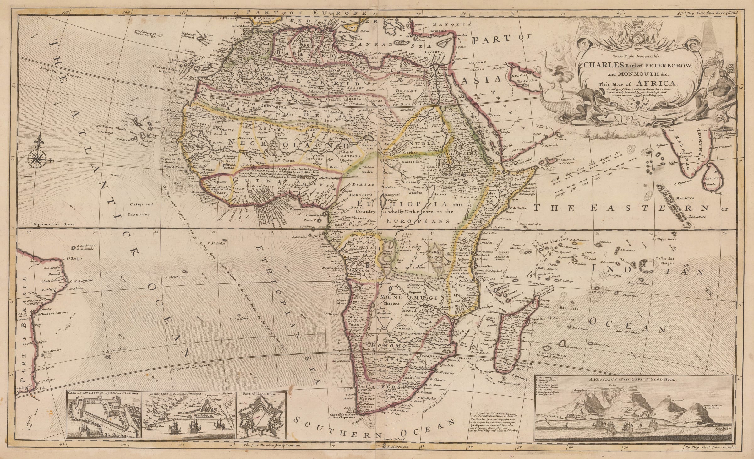
Herman Moll
59 x 99 cm
Hermann Moll’s large two sheet map of Africa was first issued as a separate publication (ie as a separate map not bound in an atlas) in the early 18th century. It was part of group of maps of the same size and style which supplemented Moll’s income as an independent publisher while he also worked for other map makers and publishers such as John Harris and Robert Morden.
Approximately in 1715, Moll collected this series of large maps and bound them in an atlas entitled “The World Described”. It was Moll’s flagship product and proved very popular. Unusually, some of Moll’s maps transcended a purely geographical function as he used them as propaganda tools as well as a publicity for his other publications. Moll would continue to revise and add to its content throughout much of his life. Its financial success can be attested by several editions published after Moll’s death in 1732.
Africa is one of the earliest maps which Moll drew and engraved in this series. As with much of his work, the outline of the continent is broadly based on the map of Africa by Guillaume de L’Isle issued in 1700. Much of the nomenclature in the interior is based on the same map, with straight translations from French into English names.
There are, however certain features where the two maps differ markedly: The shape of Madagascar refers to much earlier geographical detail. Although the maps roughly cover the same geographical area, from the east coast of Brazil to the southwest coast of India, Moll adds a sailing route to the East Indies and, on the lower border, several vignettes of important ports along that route, including Cape Town, Cape Castle in modern Ghana and St. James on the island of Sta. Helena.
The interior also shows some crucial differences from de L’Isle’s map. The greatest is Moll’s persistence with two large mythical lakes in the unknown centre of the continent, believed to be the source of the White Nile since Graeco-Roman times. This theory was followed by later cartographers and adapted to show the lakes as sources for many of the other large rivers in Africa. Despite this geographically backward step, Moll is surprisingly honest in one aspect of the geography of the interior when he states that a large part of central Africa is “Ethiopia, this country is Unknown to the Europeans.”
As with all of Moll’s two sheet maps, the cartouche is large and prominent, showing an allegorical female figure for the continent as well as a scene of crocodile wrestling which seems to be ubiquitous to maps of Africa during this period.
This is the first posthumous edition of the map issued c.1733.
Original colour. [AFR6266]
- X
- Tumblr
Join our mailing list
* denotes required fields
We will process the personal data you have supplied to communicate with you in accordance with our Privacy Policy. You can unsubscribe or change your preferences at any time by clicking the link in our emails.
Contact
The Map House
54 Beauchamp Place,
London SW3 1NY,
United Kingdom
maps@themaphouse.com
+44 (0)20 7589 4325
![]()
This website uses cookies
This site uses cookies to help make it more useful to you. Please contact us to find out more about our Cookie Policy.
Join our mailing list
* denotes required fields
We will process the personal data you have supplied to communicate with you in accordance with our Privacy Policy. You can unsubscribe or change your preferences at any time by clicking the link in our emails.