- All
- AFRICA
- ▪ Central Africa
- ▪ East Africa
- ▪ North Africa
- ▪ Southern Africa
- ▪ West Africa
- ▪ Atlantic Islands
- AMERICAS
-
▪ United States (USA)
- USA - East
- USA - Midwest
- USA - Northeast
- USA - Southeast
- USA - West & Southwest
- Alabama
- Alaska
- Arizona
- Arkansas
- California
- Colorado
- Connecticut
- Delaware
- Florida
- Georgia
- Hawaii
- Idaho
- Illinois
- Indiana
- Iowa
- Kansas
- Kentucky
- Louisiana
- Maine
- Maryland
- Massachusetts
- Michigan
- Minnesota
- Mississippi
- Missouri
- Montana
- Nebraska
- Nevada
- New Hampshire
- New Jersey
- New Mexico
- New York
- New York City
- North Carolina
- North Dakota
- Ohio
- Oklahoma
- Oregon
- Pennsylvania
- Rhode Island
- South Carolina
- South Dakota
- Tennessee
- Texas
- Utah
- Vermont
- Virginia
- Washington
- Washington, D.C.
- West Virginia
- Wisconsin
- Wyoming
- ▪ North America
- ▪ South America
- ▪ Caribbean
- ASIA
- ▪ East Asia
- ▪ Southeast Asia
- ▪ India & South Asia
- ▪ Middle East & Turkey
- BRITISH ISLES
- ▪ London
-
▪ England
- English Cities
- Bedfordshire
- Berkshire
- Buckinghamshire
- Cambridgeshire
- Cheshire
- Cornwall
- Cumbria
- Derbyshire
- Devon
- Dorset
- Durham
- Essex
- Gloucestershire
- Hampshire
- Herefordshire
- Hertfordshire
- Huntingdonshire
- Isle of Wight
- Kent
- Lancashire
- Leicestershire
- Lincolnshire
- Middlesex
- Norfolk
- Northamptonshire
- Northumberland
- Nottinghamshire
- Oxfordshire
- Rutland
- Shropshire
- Somerset
- Staffordshire
- Suffolk
- Surrey
- Sussex
- Warwickshire
- Wiltshire
- Worcestershire
- Yorkshire
- Yorkshire East Riding
- Yorkshire North Riding
- Yorkshire West Riding
- ▪ Ireland
- ▪ Scotland
- ▪ Wales
- EUROPE
- ▪ Austria & Switzerland
- ▪ Benelux Region
- ▪ Central & Eastern Europe
- ▪ France & Monaco
- ▪ Germany
- ▪ Greece
- ▪ Italy
- ▪ Mediterranean Sea
- ▪ Spain & Portugal
- ▪ Scandinavia & Baltics
- ▪ Russia, Ukraine & Caucasus
- OCEANIA
- ▪ Australia
- ▪ New Zealand
- ▪ Pacific Ocean & Islands
- ▪ Papua New Guinea
- POLAR
- CELESTIAL
- WORLD
- GLOBES & INSTRUMENTS
- THEMATIC
- COLLABORATIONS
Capt. James Cook
New Zealand, 1773
20 x 16 in
51 x 41 cm
51 x 41 cm
AUNZ2954
£ 4,950.00
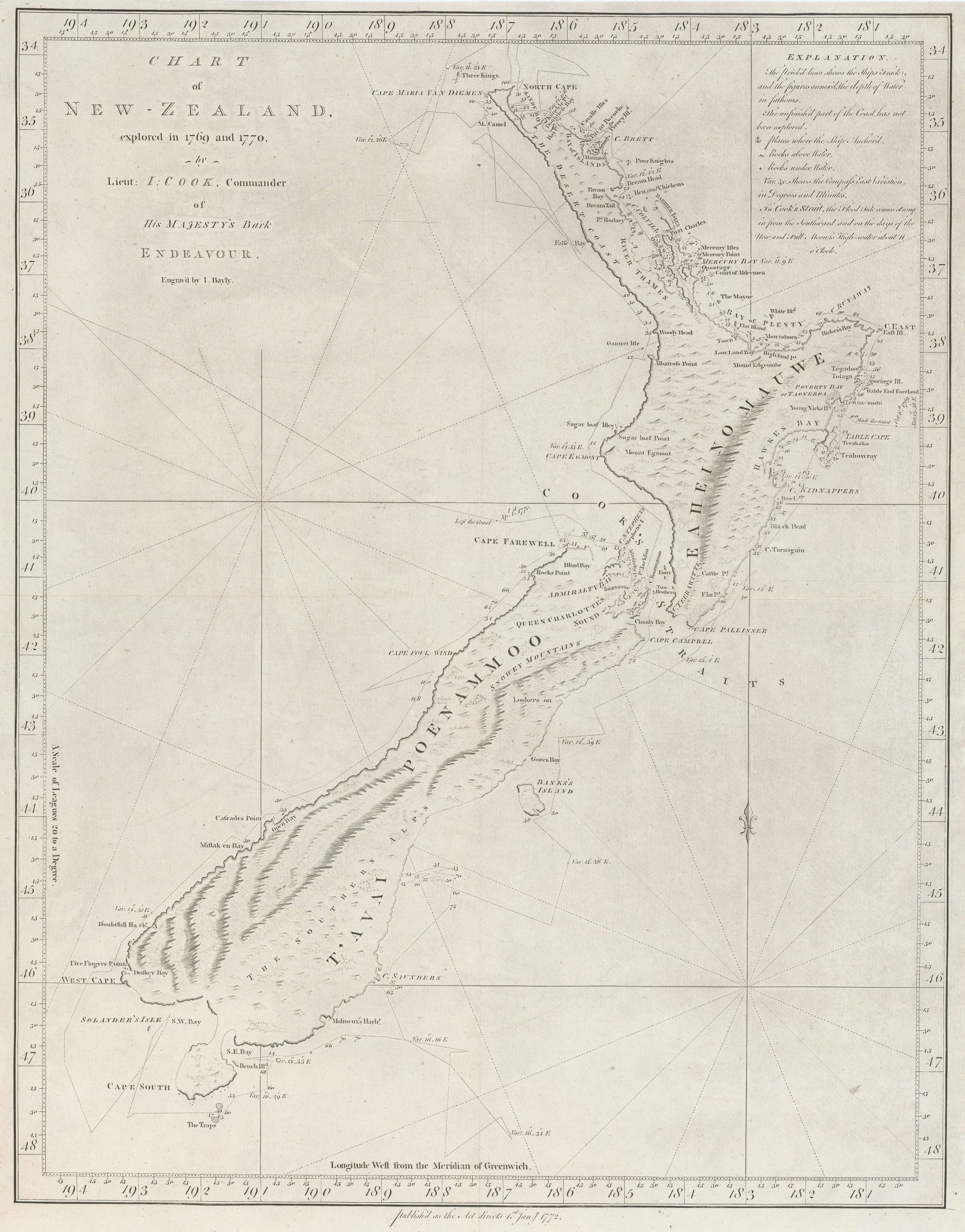
Capt. James Cook, New Zealand, 1773
Sold
%3Cdiv%20class%3D%22artist%22%3ECapt.%20James%20Cook%3C/div%3E%3Cdiv%20class%3D%22title_and_year%22%3E%3Cspan%20class%3D%22title_and_year_title%22%3ENew%20Zealand%3C/span%3E%2C%20%3Cspan%20class%3D%22title_and_year_year%22%3E1773%3C/span%3E%3C/div%3E%3Cdiv%20class%3D%22dimensions%22%3E20%20x%2016%20in%3Cbr/%3E%0A51%20x%2041%20cm%3C/div%3E
Chart of New Zealand, explored in 1769 and 1770, by Lieut: J Cook, Commander of His Majesty's Bark Endeavour The first complete survey of New Zealand performed during the...
Chart of New Zealand, explored in 1769 and 1770, by Lieut: J Cook, Commander of His Majesty's Bark Endeavour
The first complete survey of New Zealand performed during the first voyage of James Cook (1769-71).
This is a cornerstone map of any collection of maps of New Zealand as well as Pacific Islands. It determined that New Zealand consisted of two islands, established their shape with remarkable accuracy and finally laid to rest the theory that they were somehow connected to a large southern landmass, or Great Southern Unknow Land whose roots can be traced to 16th and 17th century maps. The route of Cook’s ship, the Royal Navy sloop, Endeavour, is clearly marked painstakingly crawling along the shore line, taking measurements and recording them for posterity. The crew amused themselves with their descriptive names of various coastal features on the islands among which include “Snowy Mountains”, “Bay of Plenty”, “Cape Foul Wind” and the “Desert Coast” among many others.
Although the title of the map refers to the original Dutch name, the two islands are labelled by their Maori names.
This is the first edition of the map, issued in the Strahan and Cadell version of Hawkesworth’s “ An Account of the Voyages undertaken by the Order of his Present Majesty for making Discoveries in the Southern Hemisphere”. Although the engraving date on the map is 1772, the work was not issued until 1773.
[AUNZ2954]
Share
- Tumblr
Join our mailing list
* denotes required fields
We will process the personal data you have supplied to communicate with you in accordance with our Privacy Policy. You can unsubscribe or change your preferences at any time by clicking the link in our emails.
Contact
The Map House
54 Beauchamp Place,
London SW3 1NY,
United Kingdom
maps@themaphouse.com
+44 (0)20 7589 4325
![]()
Copyright © 2025 The Map House
This website uses cookies
This site uses cookies to help make it more useful to you. Please contact us to find out more about our Cookie Policy.