- All
- AFRICA
- ▪ Central Africa
- ▪ East Africa
- ▪ North Africa
- ▪ Southern Africa
- ▪ West Africa
- ▪ Atlantic Islands
- AMERICAS
-
▪ United States (USA)
- USA - East
- USA - Midwest
- USA - Northeast
- USA - Southeast
- USA - West & Southwest
- Alabama
- Alaska
- Arizona
- Arkansas
- California
- Colorado
- Connecticut
- Delaware
- Florida
- Georgia
- Hawaii
- Idaho
- Illinois
- Indiana
- Iowa
- Kansas
- Kentucky
- Louisiana
- Maine
- Maryland
- Massachusetts
- Michigan
- Minnesota
- Mississippi
- Missouri
- Montana
- Nebraska
- Nevada
- New Hampshire
- New Jersey
- New Mexico
- New York
- New York City
- North Carolina
- North Dakota
- Ohio
- Oklahoma
- Oregon
- Pennsylvania
- Rhode Island
- South Carolina
- South Dakota
- Tennessee
- Texas
- Utah
- Vermont
- Virginia
- Washington
- Washington, D.C.
- West Virginia
- Wisconsin
- Wyoming
- ▪ North America
- ▪ South America
- ▪ Caribbean
- ASIA
- ▪ East Asia
- ▪ Southeast Asia
- ▪ India & South Asia
- ▪ Middle East & Turkey
- BRITISH ISLES
- ▪ London
-
▪ England
- English Cities
- Bedfordshire
- Berkshire
- Buckinghamshire
- Cambridgeshire
- Cheshire
- Cornwall
- Cumbria
- Derbyshire
- Devon
- Dorset
- Durham
- Essex
- Gloucestershire
- Hampshire
- Herefordshire
- Hertfordshire
- Huntingdonshire
- Isle of Wight
- Kent
- Lancashire
- Leicestershire
- Lincolnshire
- Middlesex
- Norfolk
- Northamptonshire
- Northumberland
- Nottinghamshire
- Oxfordshire
- Rutland
- Shropshire
- Somerset
- Staffordshire
- Suffolk
- Surrey
- Sussex
- Warwickshire
- Wiltshire
- Worcestershire
- Yorkshire
- Yorkshire East Riding
- Yorkshire North Riding
- Yorkshire West Riding
- ▪ Ireland
- ▪ Scotland
- ▪ Wales
- EUROPE
- ▪ Austria & Switzerland
- ▪ Benelux Region
- ▪ Central & Eastern Europe
- ▪ France & Monaco
- ▪ Germany
- ▪ Greece
- ▪ Italy
- ▪ Mediterranean Sea
- ▪ Spain & Portugal
- ▪ Scandinavia & Baltics
- ▪ Russia, Ukraine & Caucasus
- OCEANIA
- ▪ Australia
- ▪ New Zealand
- ▪ Pacific Ocean & Islands
- ▪ Papua New Guinea
- POLAR
- CELESTIAL
- WORLD
- GLOBES & INSTRUMENTS
- THEMATIC
- COLLABORATIONS
John Thomson
51 x 51 cm (each)
Further images
John Thomson was a highly successful commercial mapmaker in the early-19th century. He is cited, along with John Pinkerton, as one of the leading map makers of the Scottish Enlightenment. His New General Atlas was first issued in 1817 and then re-issued several times through the next twenty five years.
Unfortunately, Thomson's next project was less successful. In 1820, he embarked upon a new survey of Scotland and the first to be performed on a county by county basis. It was a much needed enterprise as it was only the second detailed survey of the country. However, the time, expense and lack of widespread commercial appeal for the project led to Thomson declaring bankruptcy in 1830. He was rescued by wealthy friends and acquaintances from this predicament; undeterred he continued with his Atlas of Scotland but he still faced the same hurdles and this led to another declaration of bankruptcy in 1835. Little is known about him after that date and he is believed to have died in 1840.
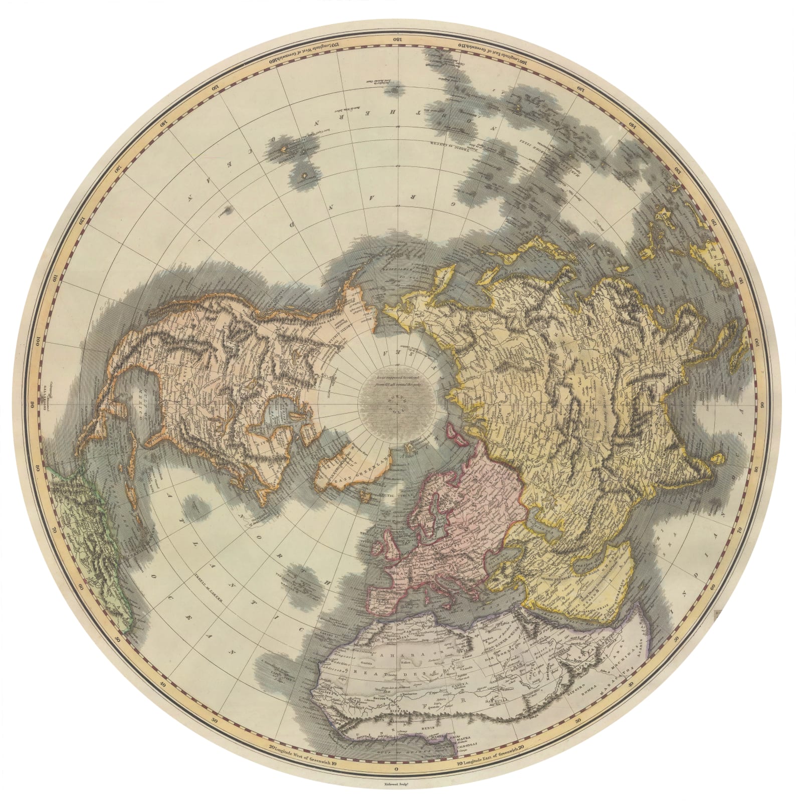
This map of the world was issued in his New General Atlas in two sheets, showing the northern and southern hemispheres. It takes full advantage of the momentous discoveries by English mariners of the late 18th century, showcasing the voyages of Cook, Vancouver, and the lesser-known Captain John Gore and Lieutenant Richard Pickersgill.
Geographically, the map is orthodox for the period, using current sources researched by Thomson's contemporaries. The overall shape of the continents is based on William Faden's double hemisphere map which was first issued in 1802, although Thomson does add greater detail, especially on the Pacific Northwest coast as a result to Vancouver's journey. The map does not add the information provided by Lewis and Clark, suggesting that the engraving dates of these maps was c.1814. This coincides with the publishing of Flinders's survey of Australia, which is shown on the map. In Africa, the Nile is shown as having two major sources in central Africa, in the mythical Mountains of the Moon. Asia again follows Faden with the exception of Japan, which is quite different to its parent map. Thomson differs both in the portrayal of the shape of the islands and the shape of Yesso.
Most intriguing of all, Thomson covers the unexplored Antarctic Regions with a hazy cloud, a stark visual reminder that nothing was yet known about this part of the Globe. Captain Cook's southernmost point is noted on the map, but no confirmed sighting of land had yet been achieved.
The printed image of each map measures appx. 20 x 21in. Original hand colour. Framed in custom-made circular frames. [WLD4738]
- X
- Tumblr
Join our mailing list
* denotes required fields
We will process the personal data you have supplied to communicate with you in accordance with our Privacy Policy. You can unsubscribe or change your preferences at any time by clicking the link in our emails.
Contact
The Map House
54 Beauchamp Place,
London SW3 1NY,
United Kingdom
maps@themaphouse.com
+44 (0)20 7589 4325

This website uses cookies
This site uses cookies to help make it more useful to you. Please contact us to find out more about our Cookie Policy.
Join our mailing list
* denotes required fields
We will process the personal data you have supplied to communicate with you in accordance with our Privacy Policy. You can unsubscribe or change your preferences at any time by clicking the link in our emails.


