- All
- AFRICA
- ▪ Central Africa
- ▪ East Africa
- ▪ North Africa
- ▪ Southern Africa
- ▪ West Africa
- ▪ Atlantic Islands
- AMERICAS
-
▪ United States (USA)
- USA - East
- USA - Midwest
- USA - Northeast
- USA - Southeast
- USA - West & Southwest
- Alabama
- Alaska
- Arizona
- Arkansas
- California
- Colorado
- Connecticut
- Delaware
- Florida
- Georgia
- Hawaii
- Idaho
- Illinois
- Indiana
- Iowa
- Kansas
- Kentucky
- Louisiana
- Maine
- Maryland
- Massachusetts
- Michigan
- Minnesota
- Mississippi
- Missouri
- Montana
- Nebraska
- Nevada
- New Hampshire
- New Jersey
- New Mexico
- New York
- New York City
- North Carolina
- North Dakota
- Ohio
- Oklahoma
- Oregon
- Pennsylvania
- Rhode Island
- South Carolina
- South Dakota
- Tennessee
- Texas
- Utah
- Vermont
- Virginia
- Washington
- Washington, D.C.
- West Virginia
- Wisconsin
- Wyoming
- ▪ North America
- ▪ South America
- ▪ Caribbean
- ASIA
- ▪ East Asia
- ▪ Southeast Asia
- ▪ India & South Asia
- ▪ Middle East & Turkey
- BRITISH ISLES
- ▪ London
-
▪ England
- English Cities
- Bedfordshire
- Berkshire
- Buckinghamshire
- Cambridgeshire
- Cheshire
- Cornwall
- Cumbria
- Derbyshire
- Devon
- Dorset
- Durham
- Essex
- Gloucestershire
- Hampshire
- Herefordshire
- Hertfordshire
- Huntingdonshire
- Isle of Wight
- Kent
- Lancashire
- Leicestershire
- Lincolnshire
- Middlesex
- Norfolk
- Northamptonshire
- Northumberland
- Nottinghamshire
- Oxfordshire
- Rutland
- Shropshire
- Somerset
- Staffordshire
- Suffolk
- Surrey
- Sussex
- Warwickshire
- Wiltshire
- Worcestershire
- Yorkshire
- Yorkshire East Riding
- Yorkshire North Riding
- Yorkshire West Riding
- ▪ Ireland
- ▪ Scotland
- ▪ Wales
- EUROPE
- ▪ Austria & Switzerland
- ▪ Benelux Region
- ▪ Central & Eastern Europe
- ▪ France & Monaco
- ▪ Germany
- ▪ Greece
- ▪ Italy
- ▪ Mediterranean Sea
- ▪ Spain & Portugal
- ▪ Scandinavia & Baltics
- ▪ Russia, Ukraine & Caucasus
- OCEANIA
- ▪ Australia
- ▪ New Zealand
- ▪ Pacific Ocean & Islands
- ▪ Papua New Guinea
- POLAR
- CELESTIAL
- WORLD
- GLOBES & INSTRUMENTS
- THEMATIC
- COLLABORATIONS
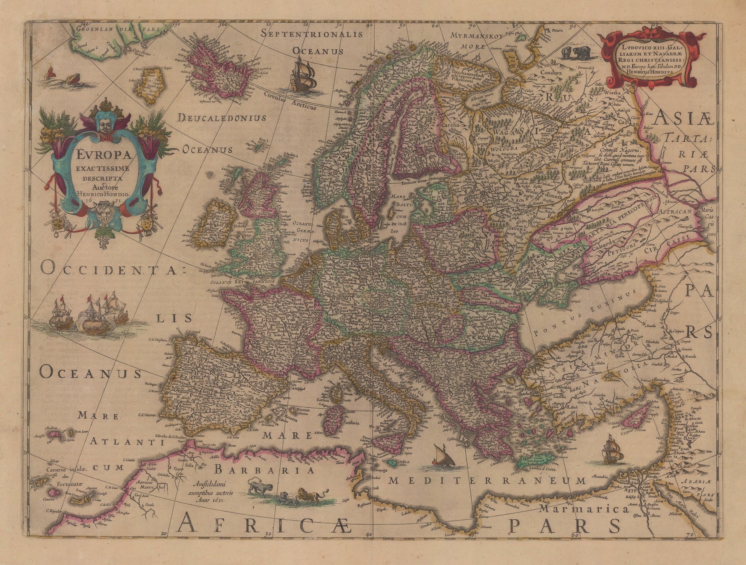
Henricus Hondius
38 x 50 cm
Beautiful example of Henricus Hondius’s important map of Europe published in his Atlas Novus, the revised and augmented edition of the firm’s authoritative atlas first issued in 1606.
Geographically, the map is derived from Jodocus Hondius’s II (brother to Henricus) separately issued 1619 map of Europe. That map had elaborate borders illustrating costumed figures and important cities in the continent. This earlier map had many features in common with a map issued by Willem Blaeu in 1617. Blaeu’s map was itself a reduction of a wall map published by the same firm in 1608.
However, a closer look at the maps by Blaeu of 1617 and Hondius of 1619 shows distinct differences which illustrate several geographical advances recorded by Hondius since 1608. Most notable is the shape of Great Britain and Ireland which is now far more defined, particularly Cornwall, Scotland and the southern coast of Ireland. These advances were based on the work of John Speed who published his map of Great Britain in 1611. Hondius also names the Irish Sea, a feature missing from Blaeu’s map. Other notable advances and changes include the addition of Lake Ladoga east of the Gulf of Finland, the shape of Scandinavia and the conversion of the Kanin Peninsula to an island east of the White Sea. The White Sea itself has also been considerably altered in shape.
In the south, the north coast of Spain is now a gentle bow as opposed to a straight line, Italy has been elongated, Sardinia is larger than on previous maps and Sicily has been altered in shape and bears much greater detail. Of particular note is the addition of the western shore of the Caspian Sea and a far better delineation of the Caucasus. This was sourced from Hessel Gerritz’s important new map of Russia first published in 1614.
Henricus Hondius acquired this plate after the death of his brother in 1629 and began to use it without the illustrated borders, most likely due to cost, after 1631. It became the de facto map of Europe within the newly launched “Atlas Novus” and would later continue its long publishing life within versions of the same work issued by Johannes Jansson, brother-in-law to Henricus, after the latter passed away.
This particular example has Latin text on the reverse. We have been unable to track down the exact edition but there were Latin editions published in 1636 and 1638; in 1641, Johannes Jansson added his name to the map just below the cartouche, a feature this map lacks.
The dedication on the upper right is to Louis XIII of France, a signal of Hondius’s strong connection to the French market, particularly through the influence of his uncle Petrus Bertius, court cartographer to Louis until his death in 1629.
Original colour. Image of reverse available on request. [EUR1542]
- X
- Tumblr
Join our mailing list
* denotes required fields
We will process the personal data you have supplied to communicate with you in accordance with our Privacy Policy. You can unsubscribe or change your preferences at any time by clicking the link in our emails.
Contact
The Map House
54 Beauchamp Place,
London SW3 1NY,
United Kingdom
maps@themaphouse.com
+44 (0)20 7589 4325
![]()
This website uses cookies
This site uses cookies to help make it more useful to you. Please contact us to find out more about our Cookie Policy.
Join our mailing list
* denotes required fields
We will process the personal data you have supplied to communicate with you in accordance with our Privacy Policy. You can unsubscribe or change your preferences at any time by clicking the link in our emails.