- All
- AFRICA
- ▪ Central Africa
- ▪ East Africa
- ▪ North Africa
- ▪ Southern Africa
- ▪ West Africa
- ▪ Atlantic Islands
- AMERICAS
-
▪ United States (USA)
- USA - East
- USA - Midwest
- USA - Northeast
- USA - Southeast
- USA - West & Southwest
- Alabama
- Alaska
- Arizona
- Arkansas
- California
- Colorado
- Connecticut
- Delaware
- Florida
- Georgia
- Hawaii
- Idaho
- Illinois
- Indiana
- Iowa
- Kansas
- Kentucky
- Louisiana
- Maine
- Maryland
- Massachusetts
- Michigan
- Minnesota
- Mississippi
- Missouri
- Montana
- Nebraska
- Nevada
- New Hampshire
- New Jersey
- New Mexico
- New York
- New York City
- North Carolina
- North Dakota
- Ohio
- Oklahoma
- Oregon
- Pennsylvania
- Rhode Island
- South Carolina
- South Dakota
- Tennessee
- Texas
- Utah
- Vermont
- Virginia
- Washington
- Washington, D.C.
- West Virginia
- Wisconsin
- Wyoming
- ▪ North America
- ▪ South America
- ▪ Caribbean
- ASIA
- ▪ East Asia
- ▪ Southeast Asia
- ▪ India & South Asia
- ▪ Middle East & Turkey
- BRITISH ISLES
- ▪ London
-
▪ England
- English Cities
- Bedfordshire
- Berkshire
- Buckinghamshire
- Cambridgeshire
- Cheshire
- Cornwall
- Cumbria
- Derbyshire
- Devon
- Dorset
- Durham
- Essex
- Gloucestershire
- Hampshire
- Herefordshire
- Hertfordshire
- Huntingdonshire
- Isle of Wight
- Kent
- Lancashire
- Leicestershire
- Lincolnshire
- Middlesex
- Norfolk
- Northamptonshire
- Northumberland
- Nottinghamshire
- Oxfordshire
- Rutland
- Shropshire
- Somerset
- Staffordshire
- Suffolk
- Surrey
- Sussex
- Warwickshire
- Wiltshire
- Worcestershire
- Yorkshire
- Yorkshire East Riding
- Yorkshire North Riding
- Yorkshire West Riding
- ▪ Ireland
- ▪ Scotland
- ▪ Wales
- EUROPE
- ▪ Austria & Switzerland
- ▪ Benelux Region
- ▪ Central & Eastern Europe
- ▪ France & Monaco
- ▪ Germany
- ▪ Greece
- ▪ Italy
- ▪ Mediterranean Sea
- ▪ Spain & Portugal
- ▪ Scandinavia & Baltics
- ▪ Russia, Ukraine & Caucasus
- OCEANIA
- ▪ Australia
- ▪ New Zealand
- ▪ Pacific Ocean & Islands
- ▪ Papua New Guinea
- POLAR
- CELESTIAL
- WORLD
- GLOBES & INSTRUMENTS
- THEMATIC
- COLLABORATIONS
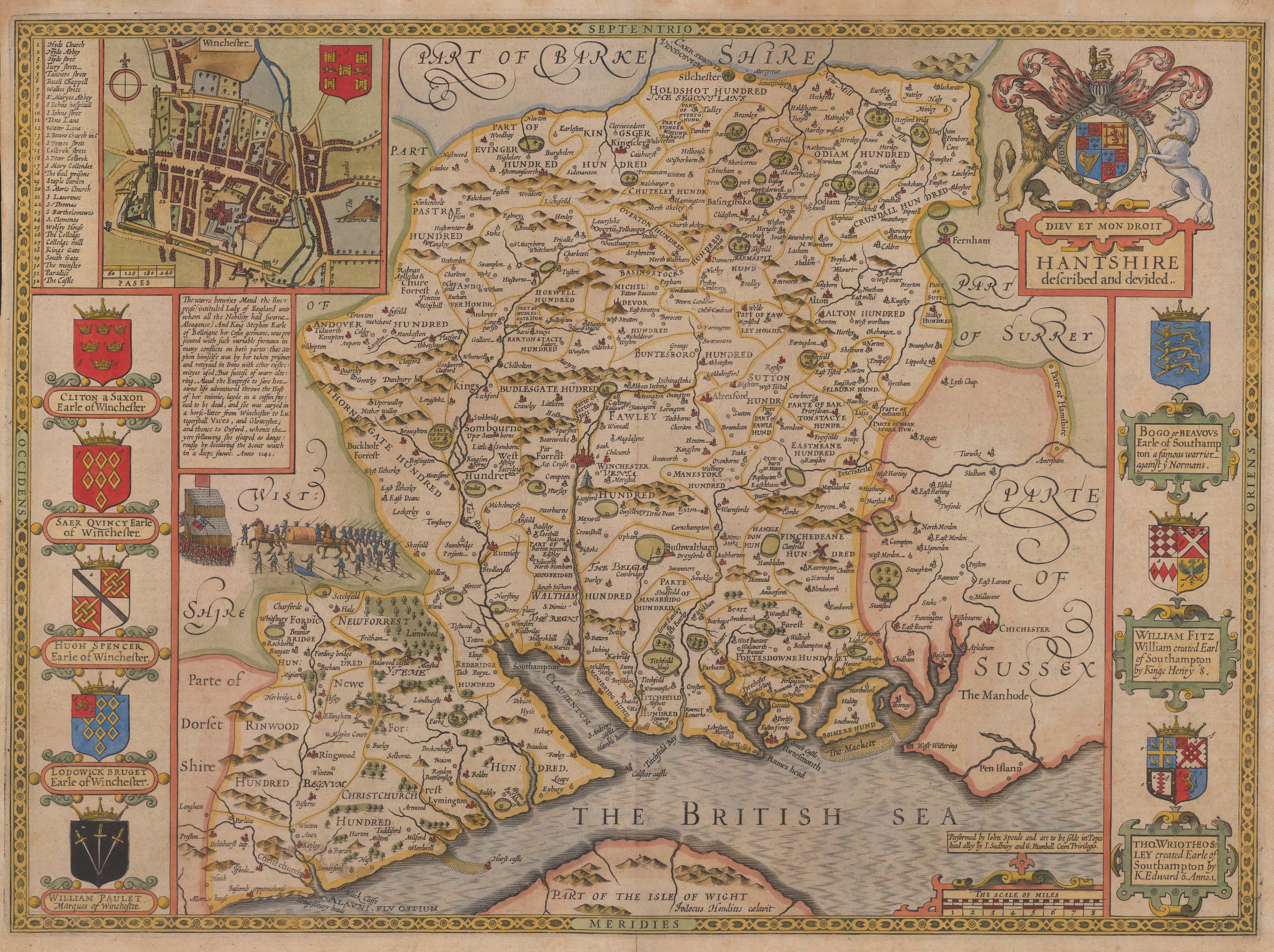
John Speed
Hantshire described and devided, 1627
15 x 20 ½ in
38 x 52 cm
38 x 52 cm
HANTS702
£ 2,550.00
John Speed, Hantshire described and devided, 1627
Sold
%3Cdiv%20class%3D%22artist%22%3EJohn%20Speed%3C/div%3E%3Cdiv%20class%3D%22title_and_year%22%3E%3Cspan%20class%3D%22title_and_year_title%22%3EHantshire%20described%20and%20devided%3C/span%3E%2C%20%3Cspan%20class%3D%22title_and_year_year%22%3E1627%3C/span%3E%3C/div%3E%3Cdiv%20class%3D%22dimensions%22%3E15%20x%2020%20%C2%BD%20in%3Cbr/%3E%0A38%20x%2052%20cm%3C/div%3E
Splendid county map of Hampshire with an inset town plan of Winchester. From the 1627 edition of John Speed's 'The Theatre of the Empire of Great Britaine', the first complete...
Splendid county map of Hampshire with an inset town plan of Winchester. From the 1627 edition of John Speed's "The Theatre of the Empire of Great Britaine", the first complete atlas of English counties. The map is decorated by a large royal coat of arms belonging to King James I, the sovereign at the time of publication. The arms of local nobles are also displayed along the sides of the map.
Geographically, the map was loosely based on Saxton although the Hampshire coast was of great strategic importance to the country, with Portsmouth being one of the most significant naval towns. Geographical surveys of the region, particularly the coastline, were frequently conducted. The accuracy of the coastline of this map is notably better then in many other maps by Speed. The inset of Winchester was the first topographical printed view of the city and based on first hand information by John Speed.
Just below the map of Winchester there is a fascinating illustration and text panel describing the 12th-century civil war between King Stephen and the Empress Matilda, two of Britain's lesser-known rulers. The vignette shows Matilda escaping from Stephen's army by hiding in a coffin and pretending to be dead. The ploy worked and Matilda escaped to safety. Matilda ultimately recognized Stephen's right to rule, but only after her son, Henry II, was named heir to the throne. This period is known as "the Anarchy" and is regarded as one of the lowest points in Britain's governing history.
English text on verso. Image available on request. Coloured. [HANTS702]
Share
- Tumblr
Join our mailing list
* denotes required fields
We will process the personal data you have supplied to communicate with you in accordance with our Privacy Policy. You can unsubscribe or change your preferences at any time by clicking the link in our emails.
Contact
The Map House
54 Beauchamp Place,
London SW3 1NY,
United Kingdom
maps@themaphouse.com
+44 (0)20 7589 4325
![]()
Copyright © 2025 The Map House
This website uses cookies
This site uses cookies to help make it more useful to you. Please contact us to find out more about our Cookie Policy.